Key Takeaways
-
The Gulf of Khambhat is located on the west coast of India, in the state of Gujarat.
Four rivers drain into the Gulf of Khambhat, including the Narmada, the Tapi, the Mahi, and the Sabarmati.
Related Stories
The Gulf of Khambhat is also known as the Gulf of Cambay.
These four rivers form estuaries, not a delta, at the mouth of the Gulf of Khambhat.
The Gulf of Khambhat is the largest inlet of the Arabian Sea along the coast of Gujarat. In this gulf, there are mainly 4 rivers that drain into it: the Narmada, the Tapi, the Mahi, and the Sabarmati.
All four of these rivers flow from east to west and finally empty into the Arabian Sea through the Gulf of Khambhat.
This topic is very important for students who are preparing for UPSC, State PCS, SSC, or any government exam in geography because questions on rivers are generally asked in various competitive exams.
So, explore this article and learn all about the Gulf of Khambhat, the origin of all four rivers that drain into it, with key takeaways.
About the Gulf of Khambhat
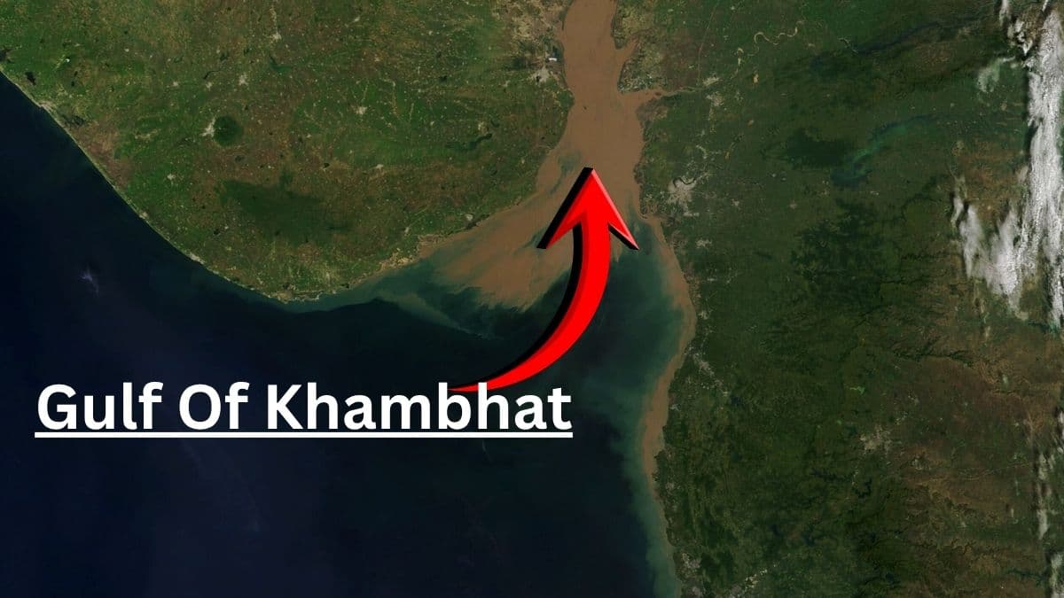
The Gulf of Khambhat, which is also known as the Gulf of Cambay, is an inlet of the Arabian Sea along the west coast of Gujarat, in India.
It divides the Kathiawar Peninsula from the south-eastern part of Gujarat. It is much wider in the south, but on the northern side, it becomes narrow.
Source: NASA
The Gulf of Khambhat is also famous for its hugest tidak range, not only in India but also in the world, which means the difference between high tides and low tides is very large in this gulf.
Which 4 rivers drain into the Gulf of Khambhat?
The 4 rivers that drain into the Gulf of Khambhat are:
-
Narmada River
-
Tapi River
-
Mahi River
-
Sabarmati River
|
River
|
Origin
|
Approx. Length
|
|
Narmada
|
Amarkantak, Madhya Pradesh
|
About 1,312 km
|
|
Tapi
|
Multai, Madhya Pradesh
|
About 724 km
|
|
Mahi
|
Vindhya hills, Madhya Pradesh
|
About 580 km
|
|
Sabarmati
|
Aravalli hills, Rajasthan
|
About 371 km
|
Narmada River
-
Origin: Rises from spring at Narmada Kund in Amarkantak, Madhya Pradesh, at Maikal Hills at an elevation of 1057 metres
-
Also known as Rewa, Amarja, Mekalkanya and Rudrakanya
-
Also known as “Life Line of Madhya Pradesh”
-
Passing State: Travel through three Indian states, Madhya Pradesh, Maharashtra, and Gujarat
-
Major Tributaries: Baran River, Hiran River, Kolar River, Tawa River (largest left bank tributaries)
-
Major Waterfalls: Dhuandhar Falls and Kapildhara near Jabalpur and Amarkantak
Tapi River
-
Origin: Rises at Multai in Betul district of Madhya Pradesh, in Satpura Range
-
Major Tributaries: Purna, Girna, and Panjhra
-
Passing State: Travel through three Indian states, Madhya Pradesh, Maharashtra, and Gujarat
Mahi River
-
Origin: Rises in the Vindhya Range in the Dhar district of Madhya Pradesh, at an elevation of the 500 metres above sea level.
-
Passing State: Travel through three Indian states, Madhya Pradesh, Rajasthan, and Gujarat
-
Major Dams: Mahi Bajaj Sagar Dam in Rajasthan and the Kadana Dam in Gujarat
Sabarmati River
-
Origin: Rises from Tepur village in the Udaipur district of Rajasthan from the Dhebar Lake area.
-
Passing State: Travel through three Indian states, Rajasthan, and Gujarat
-
Major Tributaries: Wakal, Harnav Hathmati, Watrak, Sei (largest right bank tributary)
So, the west-flowing rivers of India are often asked about in competitive exams like UPSC, State PCS, SSC, Railways, and other government exams.
Frequently Asked Questions
Which four rivers drain into the Gulf of Kambhat?
The Narmada, the Tapi, the Mahi, and the Sabarmati Rivers drain into the Gulf of Khambhat.
In which state is the Gulf of Khambat located?
The Gulf of Khambhat is located in teh Gujarat state on the west coast of India.
What is another name for the Gulf of Khambhat?
The Gulf of Khambhat is also known as the “Gulf of Cambay”.