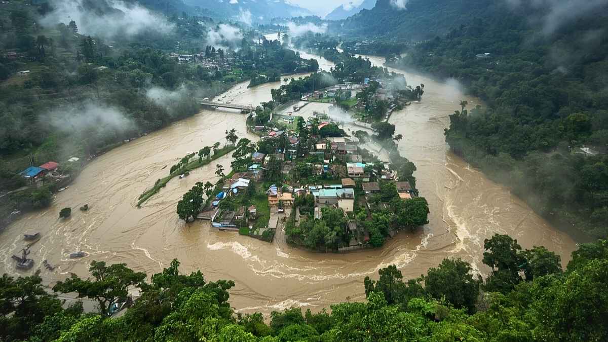
The Union Territory of Jammu and Kashmir faces intense monsoon activity with heavy rainfall and widespread flash floods, cloudbursts and landslides. The torrential rains caused rivers and mountain streams to overflow causing significant damage in regions like Rajouri, Doda, Poonch and Jammu srinagar highway.
Due to the heavy rain the water bodies including Jhelum, Chenab, Tawi, Suran, Darhali and Sindh rivers have caused flooding due to overflow of the water.
All 20 districts of Jammu and Kashmir are under emergency alerts. Check the full list of districts of Jammu and Kashmir.
List of Districts of Jammu and Kashmir
|
S.No.
|
District Name
|
Division
|
Headquarters
|
|
1
|
Jammu
|
Jammu Division
|
Jammu
|
|
2
|
Samba
|
Jammu Division
|
Samba
|
|
3
|
Kathua
|
Jammu Division
|
Kathua
|
|
4
|
Udhampur
|
Jammu Division
|
Udhampur
|
|
5
|
Reasi
|
Jammu Division
|
Reasi
|
|
6
|
Rajouri
|
Jammu Division
|
Rajouri
|
|
7
|
Poonch
|
Jammu Division
|
Poonch
|
|
8
|
Ramban
|
Jammu Division
|
Ramban
|
|
9
|
Doda
|
Jammu Division
|
Doda
|
|
10
|
Kishtwar
|
Jammu Division
|
Kishtwar
|
|
11
|
Srinagar
|
Kashmir Division
|
Srinagar
|
|
12
|
Anantnag
|
Kashmir Division
|
Anantnag
|
|
13
|
Baramulla
|
Kashmir Division
|
Baramulla
|
|
14
|
Budgam
|
Kashmir Division
|
Budgam
|
|
15
|
Pulwama
|
Kashmir Division
|
Pulwama
|
|
16
|
Kulgam
|
Kashmir Division
|
Kulgam
|
|
17
|
Shopian
|
Kashmir Division
|
Shopian
|
|
18
|
Ganderbal
|
Kashmir Division
|
Ganderbal
|
|
19
|
Bandipora
|
Kashmir Division
|
Bandipora
|
|
20
|
Kupwara
|
Kashmir Division
|
Kupwara
|
Division of Jammu and Kashmir
Jammu and Kashmir is divided into two divisions: Jammu Division and Kashmir Division.
Each division has distinct topographical features, weather patterns and hydrological profiles.
Related Stories
Jammu Division
Jammu Division comprises 10 districts. The region lies in Shivalik plains, Pir Panjal range, middle Himalayan ranges. Its geography makes it sensible for sudden cloudbursts, steep-slope landslides, highway blockages and severe flash flooding along fast-moving mountain rivers like the Chenab, Tawi, Darhali, and Suran.
Kashmir Division
Kashmir Division has 10 districts. The high-altitude intermontane basin of the Kashmir Valley. The area is drained by Jhelum River and its tributaries like Lidder, Veshaw, Sindh. It often faces prolonged waterlogging in low-lying basin areas and localised high-altitude cloudbursts.
List of Areas Affected by Floods and Landslides
|
S.No.
|
District
|
Division
|
Zone / Risk
|
Major Rivers and waterbodies
|
|
1
|
Poonch
|
Jammu
|
Critical Hazard zone
|
Suran and poonch rivers
|
|
2
|
Rajouri
|
Jammu
|
Critical Hazard zone
|
Darhali, khandli and suktoh Rivers
|
|
3
|
Ramban
|
Jammu
|
Critical Hazard zone
|
Chenab river
|
|
4
|
Kishtwar
|
Jammu
|
Critical Hazard zone
|
Chenab river and marusudar Nallah
|
|
5
|
Doda
|
Jammu
|
Critical Hazard zone
|
Chenab river
|
|
6
|
Jammu
|
Jammu
|
High alert plain zone
|
Tawi and chenab rivers
|
|
7
|
Kathua
|
Jammu
|
High alert plain zone
|
Ujh and Ravi rivers
|
|
8
|
Samba
|
Jammu
|
High alert plain zone
|
Devak and Basantar Rivulets
|
|
9
|
Reasi
|
Jammu
|
High alert plain zone
|
Chenab River’s Salal Hydro Project)
|
|
10
|
Udhampur
|
Jammu
|
High alert plain zone
|
Tawi river catchment
|
|
11
|
Srinagar
|
Kashmir
|
Riverine amd valley Basin zone
|
Jhelum river and Dal Lake
|
|
12
|
Anantnag
|
Kashmir
|
Riverine and valley Basin zone
|
Jhelum, Lidder and Veshaw
|
|
13
|
Bandipora
|
Kashmir
|
Riverine and Valley Basin zone
|
Wular Lake Basin
|
|
14
|
Baramulla
|
Kashmir
|
Riverine and valley Basin zone
|
Jhelum River (Downstream)
|
|
15
|
Pulwama
|
Kashmir
|
Riverine and valley Basin zone
|
Jhelum River & Rambiara Nallah
|
|
16
|
Kulgam
|
Kashmir
|
Riverine and Valley Basin zone
|
Veshaw Nallah (Jhelum Tributary)
|
|
17
|
Ganderbal
|
Kashmir
|
Riverine and valley Basin zone
|
Sindh River
|
|
18
|
Budgam
|
Kashmir
|
Riverine and valley Basin zone
|
Doodhganga & Sukhnag Streams
|
|
19
|
Kupwara
|
Kashmir
|
Riverine and valley Basin zone
|
Pohru & Lolab Streams
|
|
20
|
Shopian
|
Kashmir
|
Riverine and valley Basin zone
|
Rambiara River (Mughal Road Corridor)
|
What are the Reasons for Floods and Landslides in J&K?
The main reasons for floods and landslides in J&K is the impact of Monsoon currents, Cloudburts, river encroachment, unstable terrain, silt accumulation and healve spells from river buildings and saturated slopes and blocked drainage systems
The Southwest Monsoon brings moisture-laden clouds that collide with the Pir Panjal and Himalayan ranges. It causes sudden cloudbursts dumping huge volumes of water over short periods of time.
Encroachment of floodplains and riverbeds due to unplanned construction and agricultural encroachment along riverbeds like Tawi, Darhali and Jhelum. When river levels rise water overflows into nearby areas.
The clearing of forest cover for development reduces root binding on mountain slopes without trees to stabilise the soil and absorb excess rainwater, surface runoff speeds up and accelerating flash floods and slope failures.