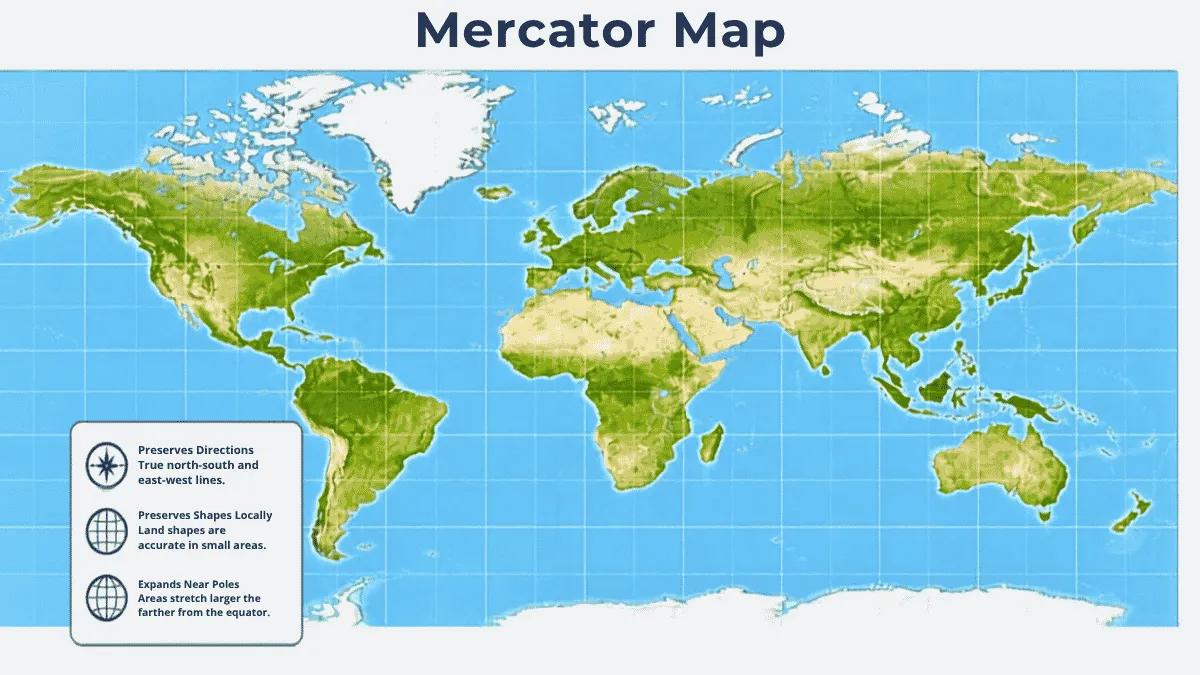
The process of converting a three-dimensional(3D) spherical globe into a two-dimensional(2D) flat surface creates a problem for the cartographer. A trade-off is required between the accuracy of retaining their relative magnitude and the accuracy of retaining their true shape. The Mercator projection and maps that are in agreement with the principle of equal-area occupy different poles of the spectrum of this dilemma.
What is a Mercator projection map?
Introduced in 1569 by Belgian geographer Gerardus Mercator, this projection provides a cylindrical conformal map. The primary motive for devising this projection was to help sailors in their navigation that is to allow them to chart straight paths (rhumb lines) across the ocean.
Related Stories
-
Essential feature: The individual angles and shapes of landmasses are maintained in the map.
Basic distortion: The map overstates the size of landmasses as one moves away from the equator.
Example: Greenland shown on a standard Mercator map, is considered to have about the same size as Africa. However in fact, Africa is approximately 14 times bigger than Greenland.
The Greenland vs. Africa illusion: The above-stated compass course leads to the common perception that Greenland has almost the same area as Africa. In reality the latter is roughly 14 times bigger compared to the former.
High latitude enlargement: Antarctica can be seen on the map as a huge white area at the bottom of the projection and the north countries like Canada and Russia are shown bigger than they actually are in comparison with the countries located along the equator.
What is Equal Area Map?
A map that falls under equal area projection is the one that rectifies the size-distortion problems of the Mercator model by making sure that any particular area of a map will represent the same area in proportion to similar areas of different positions on the globe.
-
If the area of Country A is twice as large as that of Country B in reality it will also have a double area on equal area mapping.
-
The most widely used equal area projections are the Gall-Peters equal-area projection. The Mollweide projection and the Goode-Homolosine projection.
In order to preserve the original area of certain regions on the map, equal area maps lose the property of maintaining shapes and angles intact. The outcome is that certain areas look greatly stretched or contracted with the most visible distortion seen around the corners of the map. For example, Gall-Peters projection is known for transforming the image of continents into one that is elongated from north to south with some of the landmasses looking like they are “dripping” downwards.
Differences b/w Equal-Area Map and Mercator Map
|
Feature
|
Mercator Map Projection
|
Equal-Area Map Projection
|
|
Category
|
Conformal Cylindrical Projection
|
Equal-Area / Pseudocylindrical Projection
|
|
Property Preserved
|
Local shapes, angle and compass directions
|
Relative surface area and landmass proportions
|
|
Area Distortion
|
Severe distortion near the poles (enlarges high latitudes)
|
Zero area distortion; true size ratios maintained everywhere
|
|
Shape Distortion
|
Low shape distortion for individual regions
|
High shape distortion (stretches or compresses landmasses)
|
|
Greenland vs. Africa
|
Displays Greenland as equal to or larger than Africa
|
Accurately shows Africa as 14x larger than Greenland
|
|
Primary Use Cases
|
Marine navigation, aeronautical charts, web street maps
|
Classrooms, population statistics, global climate data, UN displays
|
|
Popular Examples
|
Standard Mercator, Web Mercator (Google Maps tiles)
|
Equal Earth, Gall-Peters, Mollweide, Albers Equal Area
|
Why the Mercator Map still Dominates Digital Life
Although the Mercator map has many drawbacks, it is still the map everyone is familiar with today. Today’s web-based map services use a version of the Mercator map called Web Mercator.
Web Mercator is user-friendly in that it preserves angles, which allows roads to intersect at correct angles on the map. Additionally, it makes zooming in and out easy without any tearing issues.
When to Use Equal-Area Maps
Equal-area projections are very important when genuine scale is needed in a map. If the mapping is concerned with a global process, such as population density, deforestation, carbon emissions or climate data, choosing Mercator projection map would jeopardize the validity of analyses.
To illustrate, representation of global emissions on Mercator map would give skewed examples of emissions in particular countries invalidating conclusions because the projection distorts the size of land areas. Statisticians, geographers and social scientists prefer using equal-area projections only to ensure the correspondence of the visual image and the statistical reality it represents.