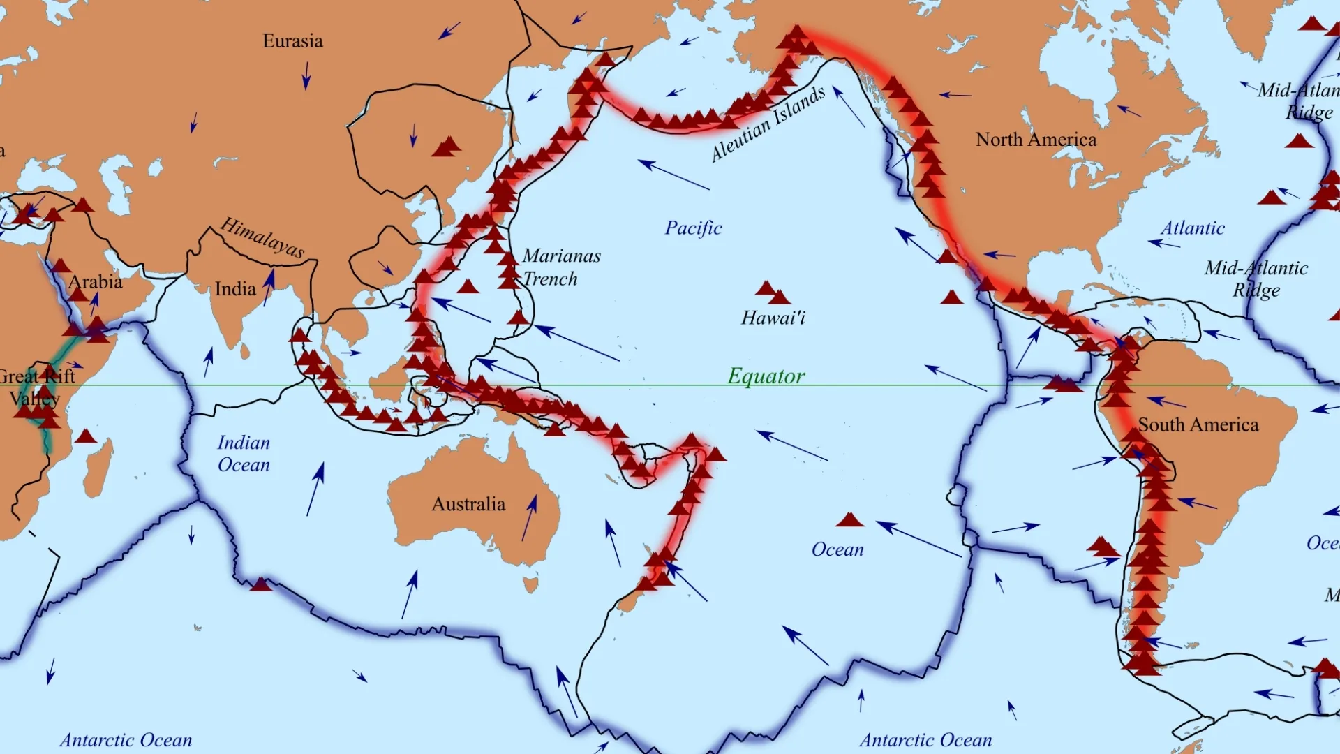
The Pacific Ring of Fire is a massive horseshoe-shaped zone of intense seismic activity that encircles the Pacific Ocean. It is not an official scientific term but a widely accepted description for a chain of active volcanoes and fault lines. This geologically unstable zone is where roughly 90% of the world's earthquakes and most volcanic eruptions occur, making it a critical area for geological research and disaster preparedness. Countries from Japan to New Zealand, and from South America to North America, are united by this common geological destiny. The frequent and often catastrophic natural disasters in this region are a direct result of the powerful movements of tectonic plates that fit together like a puzzle, constantly colliding and shifting beneath the Earth's surface.
Read About- What are the Costliest Hurricanes in the U.S.? Check Complete List Here
What is the Pacific "Ring of Fire" and What Creates Its Activity?
The Pacific Ring of Fire is a region defined by the boundaries of several major tectonic plates. Its intense activity is primarily driven by subduction zones, which are areas where one tectonic plate is forced beneath another. This collision generates immense heat and pressure, leading to the formation of magma that rises to the surface, fueling a high number of active volcanoes and dormant volcanoes. This continuous process of plates colliding, separating, or sliding past each other creates stress that, when suddenly released, results in powerful earthquakes.
Which U.S. States are Located on the "Ring of Fire" and How Are They Affected?
The United States is directly affected by the Pacific Ring of Fire. The western coastline, particularly states like Alaska, Washington, Oregon, and California, sits along this volatile boundary. Alaska, for example, has a long chain of volcanoes on the Aleutian Islands that stretch into the Bering Strait. This region is prone to major earthquakes, such as a recent 8.8 Richter scale earthquake near a Russian volcano eruption. In the lower 48 states, the Cascade Range and the San Andreas Fault are key areas of concern. These regions face a constant threat of earthquakes, tsunamis, and volcanic eruptions, which are all natural disasters born from the tectonic plate interactions of the North America and Pacific Plates.
How Do Scientists in the U.S. Prepare for Disasters Caused by the "Ring of Fire"?
In the United States, preparation for Ring of Fire disasters is led by agencies like the U.S. Geological Survey (USGS). Scientists utilize a wide range of technologies to monitor volcanic and seismic activity in real-time, including seismographs to detect earthquakes and ground deformation sensors to track the movement of magma. This data is critical for issuing public warnings and alerts, helping communities prepare for potential natural disasters. The USGS works closely with emergency management authorities to develop evacuation plans, and public campaigns like the "Drop, Cover, and Hold On" principle are used to educate the public on how to respond during an earthquake.
Must Read- Why is the Moon Red Tonight in the U.S.? Check the Science and Reason Behind here!
Conclusion
The pacific ring of fire poses a constant threat of natural disasters to the United States. With states like California and Alaska directly on its edge, the country is home to numerous active volcanoes and fault lines that can produce catastrophic earthquakes. The U.S. Geological Survey (USGS) and other agencies play a critical role in monitoring this seismic activity to protect lives and property. Understanding the geological forces at work, from tectonic plates to subduction zones, is essential for effective preparedness and for mitigating the long-term impact of these powerful natural events.


Comments
All Comments (0)
Join the conversation