-1751886431633.webp)
Alaska officially became the 49th state of the United States on January 3, 1959. Before that, it was a U.S. territory, which was purchased from Russia in 1867 through the Treaty of Cession. It added nearly one-fifth to the U.S. landmass and opened vast unexplored territory to American governance. So, from its unique geography to its indigenous culture and natural resources, Alaska is truly the United States’ last frontier and here is everything you need to know about this 49th state.
Check out: What is a Senate Bill and How it Works?
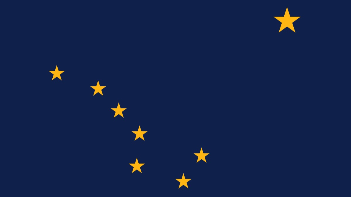
Who Made the Alaska Flag?
The Alaska flag was designed by a 13-year-old boy named Benny Benson. In 1927, he was a seventh-grader living in an orphanage in Seward when he won a contest to design a flag for the Alaska Territory. His design, which features eight gold stars, the Big Dipper and the North Star, on a blue background, was chosen from more than 700 entries and remains the official state flag today.
Source: wikipedia.org
In which country is Alaska located?
Alaska lies at the extreme northwest of the North American continent. It borders Canada’s Yukon and British Columbia, with the Arctic Ocean to the north, Pacific Ocean to the south, and Russia across the Bering Strait to the west. In fact, the 180th meridian passes through the Aleutian Islands, placing Alaska in both the Eastern and Western Hemispheres.

Source: worldatlas.com
What is the capital of Alaska?
The capital of Alaska is Juneau. It is located in the southeastern part of the state and is unique among U.S. state capitals because it is not accessible by road, visitors can only get there by flying or taking a ferry.
What are the geographical features of Alaska?
Alaska is a land of extremes, defined by its vast and varied geography. It is home to Mount McKinley (Denali), North America's highest peak, which soars to 20,310 feet (6,190 meters). The state also boasts a massive tidal coastline of over 34,000 miles and approximately 130 active volcanoes. Its landscape is shaped by massive ice fields and glaciers, and one-third of the land lies within the Arctic Circle. Significant regions of permafrost and tundra characterize its northern parts. Overall, the state's geography is divided into eight major regions, including the Aleutian Islands, Interior Basin, Brooks Range, and the North Slope.
What is the history about Alaska?
Alaska's history begins with its Indigenous peoples, who are believed to have migrated from Asia across the Bering Land Bridge thousands of years ago. These diverse groups, including the Inupiat, Yupik, Aleut, and Tlingit, adapted to the land and seas, creating rich cultures centered on hunting, fishing, and their unique environments.
The first Europeans to arrive were Russian explorers in the 18th century, who established settlements and a profitable fur trade, often forcing Indigenous peoples into labor. Over time, the Russian presence became difficult to maintain, leading them to sell the territory. In 1867, the United States purchased Alaska from Russia for $7.2 million, a deal initially mocked as "Seward's Folly" after Secretary of State William Seward.
Alaska's fortunes changed with the gold rushes of the late 19th and early 20th centuries, which brought thousands of prospectors and led to the development of new towns. Later, the discovery of oil in Prudhoe Bay in 1968 sparked another boom and led to the construction of the Trans-Alaska Pipeline. On January 3, 1959, Alaska officially became the 49th state of the United States.
Check out: BRICS Summit 2025: Check Key Agenda, Summary and Highlights
Conclusion
Hence, Alaska's importance lies in its strategic military location, rich natural resources like oil, gas, and minerals, environmental research and biodiversity. It also has a unique cultural heritage rooted in Native traditions and has potential for new shipping routes due to Arctic ice melt.


![Top 10 Most Visited Websites in the U.S. [2025]: Check List Here!](https://img.jagranjosh.com/images/2025/11/23/article/image/Most-Visited-Wbesites-1763906516864.jpg)


Comments
All Comments (0)
Join the conversation