Hurricane season of 2025 is underway, and Tropical Storm Erin has formed in the Atlantic and has become one of the most followed storms of the season. Hurricane Erin formed just west of the Cabo Verde Islands, has maximum sustained winds of about 45 mi/hr and is moving westward at a fair pace. Meteorologists are monitoring the system closely, as conditions seem to indicate that the system could undergo rapid intensification in the next few days, possibly becoming the first hurricane of the season.
At this time, no land is threatened, but early projections suggest portions of the Caribbean and parts of the southeast U.S. could experience impacts, depending on the ultimate track and evolution of Erin. As this peak time in hurricane season occurs, Erin is another reminder of the importance of preparedness and being aware of changing forecasts.
Check Out: Atlantic Hurricane Season 2025: What to Expect, Common Storm Paths and Impact Zones
This year, Erin developed into a Category 5 Hurricane. But on August 19th, 2007, she took on a much stranger form.
— Backpirch Weather (@BackpirchCrew) August 19, 2025
18 years ago today, Tropical Storm Erin suddenly re-intensified in the middle of Oklahoma, forming an eye-like feature and attaining sustained tropical winds of 60… pic.twitter.com/S4IWNyNIyX
What is Tropical Storm Erin 2025?
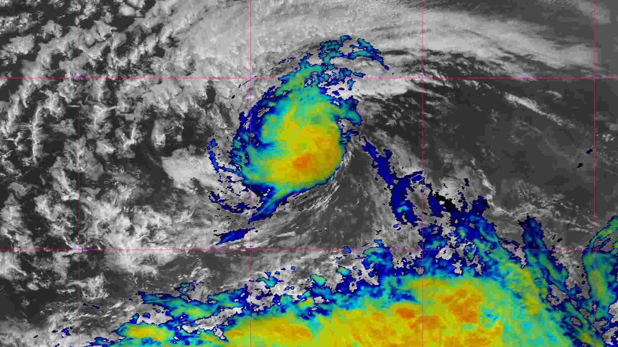
Tropical Storm Erin is an identified system in the Atlantic and continues to intensify and deepen. This system was developed on August 11, 2025, during the peak of the hurricane season in the Atlantic. It matured from a tropical wave located west of the Cabo Verde Islands and quickly became a named storm when ocean temperatures and environmental conditions exceeded 80°F.
As of publication, Erin has sustained winds of around 45 mph and is moving west at about 20 mph. It is currently just offshore and shows no imminent threat to land. However, indications are it may develop into the first named hurricane of the 2025 season in the next few days.
Unfortunately, Erin caused deadly flooding in Cape Verde before being classified, with six reported fatalities. Meteorologists are watching for any changes in direction or strength.
List of U.S. States Affected by Tropical Storm Erin (2025)
Here are some of the major U.S. States affected by tropical storm Erin in 2025:
1. Outer Banks, North Carolina
BREAKING: HURRICANE ERIN CREATING MASSIVE STORM SURGE ALONG NORTH CAROLINA OUTER BANKS.#NCWX #SCWX pic.twitter.com/yyWLJwXCcO
— Chaos Alerts (@ChaosAlertsOnX) August 20, 2025
From August 20 to 22, the Outer Banks were one of the regions hit hardest by Tropical Storm Erin, with waves estimated at 20 feet and storm surges of 2 to 4 feet resulting in severe coastal flooding. NC Highway 12, the principal thoroughfare through the barrier islands, experienced flooding and transportation disruptions.
Evacuation orders were made mandatory for Ocracoke and Hatteras Islands, and a state of emergency was declared. Erosion, debris, and power outages were also reported in what were very dangerous conditions that continued along the coast.
2. Long Island, New York
Long Island experienced strong surf and flooding from Erin, particularly on its southern beaches. Rockaway Beach was closed due to dangerous rip currents and waves from 12 to 16 feet tall.
Coastal communities along Suffolk and Nassau counties had beach erosion, flooding of roads, ferry service interruptions, and emergency alerts were issued for flood-prone areas.
Even though the storm remained largely offshore, it was substantial enough to cause a chronic impact on the region's beaches, marinas, and residential areas.
3. Jersey Shore, New Jersey
Erin caused major effects at the Jersey Shore, despite the storm passing, as it was never directly onshore. The coastal towns like Atlantic City and Seaside Heights had about 1–2 feet of flooding, and some areas saw 10+ foot waves responsible for damaging dunes and beach access.
New Jersey declared a state of emergency as local roads were flooded and emergency services responded to incidents related to the weather. Local officials urged residents to stay off the beaches and stay diligent in their precautions.
4. Virginia Beach, Virginia
Virginia Beach faced significant impacts from high surf, erosion, and coastal flooding as Erin moved offshore. Waves as high as 14 feet smashed against the shoreline with enough force to cause overwash in areas of the neighborhood and significant beach access closures.
Rip current warnings were issued, additional coastal swim warnings were issued, and lifeguards ordered no-swim orders at many popular locations. Some low-lying areas experienced brief street flooding with high tide.
Current Status and Forecast
Hurricane Erin still remains a potent Category 2 storm with maximum sustained winds near 100 mph across the Atlantic Ocean on August 22, 2025. Although the storm is no longer impacting the U.S. East Coast, it is very large. It is currently over 500 miles wide and is still generating large surf, strong rip currents, and coastal flooding from North Carolina to New England, which has led to warnings, beach closures, and state of emergency situations for some states.
Forecast guidance shows Erin continues to move northeast toward the open Atlantic and should weaken into a post-tropical system by Saturday or Sunday. While it is not forecast to reach landfall, there are no plans for Erin to diminish its ever-watchful swoop over hazards that extend from the Atlantic Ocean.
Hazardous ocean conditions are expected to linger through the weekend, although the improvements along the East Coast will start slowly to gradually take hold starting on Monday morning, and be on the lookout along coastal communities or take caution.


Comments
All Comments (0)
Join the conversation