India’s First Rock Check Dam on the Indus River: How Technology is Transforming Water Conservation
India’s First Rock Check Dam. Discover how India’s first-ever Rock Check Dam on the Indus River under the Sindhu Jal Samriddhi Abhiyan is revolutionizing eco-friendly water conservation and agricultural sustainability in Ladakh.

In the high-altitude cold desert of Ladakh, water is a seasonal paradox. Glacial meltwaters rush violently through the Indus River during peak summer, only to leave riverbeds shallow and parched when local farmers need them most. Conventional concrete dams risk cracking in extreme sub-zero temperatures and disrupt the region’s fragile ecology to bridge this gap, and India's has launched its first-ever Rock Check Dam on the Indus River.
What is India’s First Rock Check Dam on the Indus River?
The country’s first-ever rock check dam built across the mainstream of the Indus River is located at Upshi in the Leh district of Ladakh which is sitting at an altitude of 11,400 feet. It is launched under the ambitious Sindhu Jal Samriddhi Abhiyan (SJSA).
It is considered as a sustainable, low-cost solution to the region's recurring seasonal water scarcity. The dam represents a huge shift in how structural water projects are built in eco-sensitive zones rather than blocking the river completely.
The is a length 200 feet, featuring a highly stable 30-foot base-width on the riverbed that tapers up to a 15-foot wide top deck, standing 5 feet above the river channel demonstrating unparalleled execution efficiency. The entire structure was conceptualized and completed in just seven days (May 12 to May 18).
The Indus River System
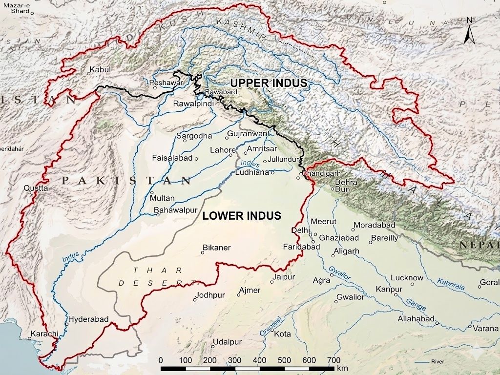
The Indus River System is one of the largest river basins in the world, serving as the lifeblood for millions of people, primarily in Pakistan, India, and parts of Tibet (China). It flows through stunning mountain gorges, feeds vast agricultural plains, and holds immense historical and geopolitical significance.
The Indus River originates in the glaciers of the Kailash Range in Tibet (near Lake Mansarovar) at an altitude of around 5,180 meters. Its total length approximately 3,180 km, making it one of the longest rivers in Asia
The course flows northwest through Ladakh and Baltistan, cuts through the Himalayas with spectacular deep gorges, turns south, and flows the entire length of Pakistan before emptying into the Arabian Sea near Karachi.
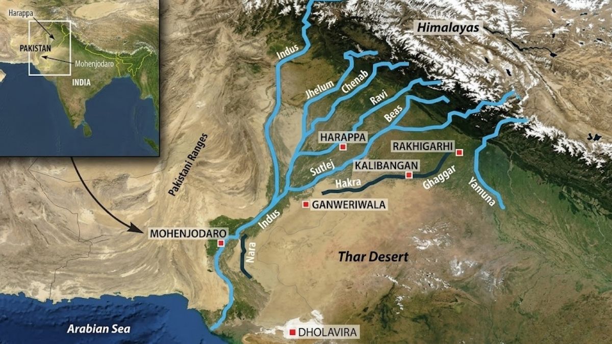
The main Tributaries of Indus (The Panjnad)
Before the Indus reaches the sea, it is joined by five major rivers on its left bank. These rivers give the region of Punjab its name (meaning "Land of Five Waters") which includes:
Jhelum(originates in Kashmir), Chenab (largest tributary of the Indus by volume), Ravi (0riginates near the Rohtang Pass in Himachal Pradesh and flows along the Indo-Pak border before joining the Chenab), Beas(originates in Himachal Pradesh and meets the Sutlej River inside India) and Sutlej( originates in Tibet and enters India before flowing into Pakistan).
Right-bank tributaries: the Shyok, Gilgit, Kabul, Gormal, and Kurram rivers.
How Rock Check Dams Work: The Science Behind Water Conservation
A rock check dam operates on the principle of permeable slowing unlike heavy concrete barriers that completely halt and store water under immense static pressure

The Mechanism of Action
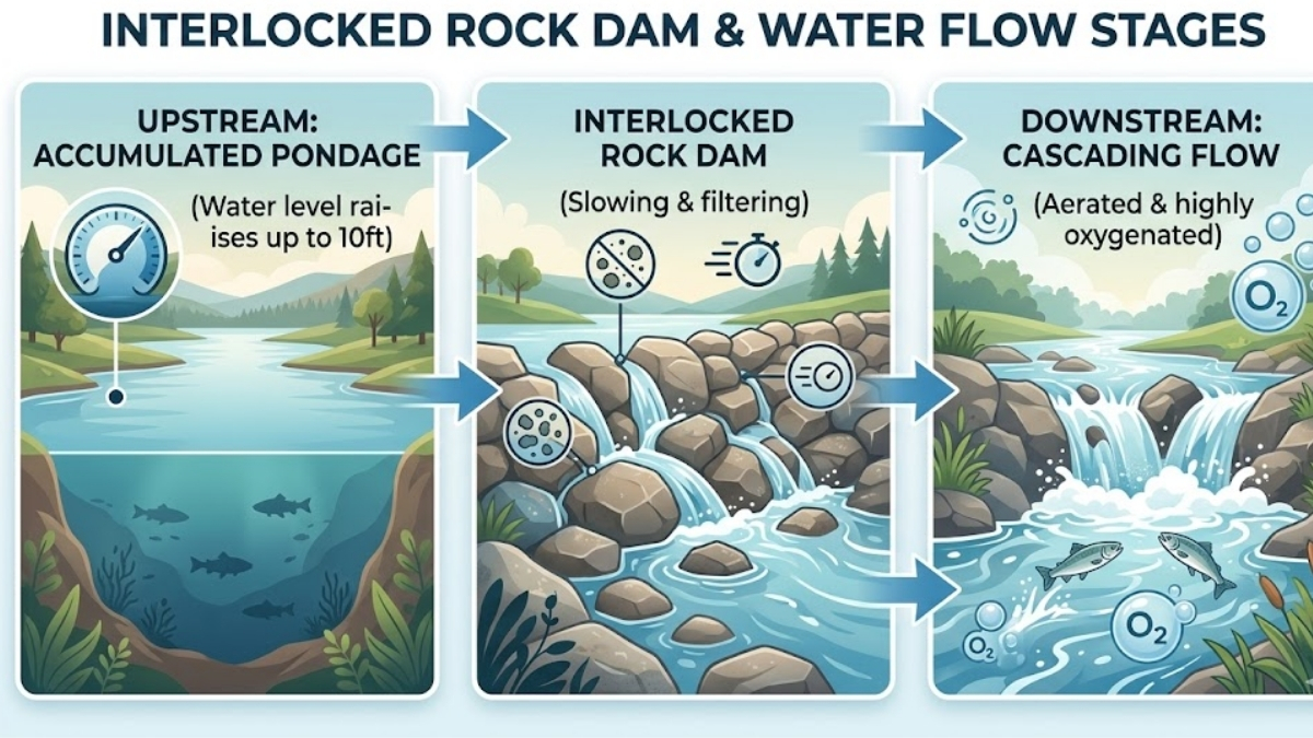
When water hits the interlocked boulders of a rock check dam, its kinetic energy is drastically reduced. The structure forces the river to pool upward, creating a massive upstream reservoir which is known as a pondage area.
As the water level rises to the top of the 5-foot barrier, excess water naturally cascades over and leaks through the semi-porous spaces between the rocks and this cascading movement generates heavy turbulence, which triggers natural aeration. This process significantly increases dissolved oxygen (oxidation) levels in the water, maintaining the biological health of the river downstream while keeping sediment traps localized.
Technology and Innovation Used in the Indus River Rock Check Dam Project
The project is backed by modern ecological planning and smart engineering technologies:
-
Hydraulic Modeling and Interlocking Layouts: Computer-aided hydraulic simulations have been used to determine exact geometric dimensions needed to withstand an eightfold surge in river pressure from 25 to 200 Cusecs without washing away.
-
Zero-Cement Material Engineering: The project deployed roughly 180 Metric Tonnes (MT) of massive rocks (from 500 kg to 10 tonnes each) by interlocking these stones into the riverbed based on stress-distribution mapping.
-
GIS and Community-Sourced Mapping: Geographic Information Systems (GIS) and terrain mapping were paired with traditional community insights to locate the optimal narrow stretches of Indus River and it would deliver maximum pooling with minimal territorial flooding.
Key Benefits of the Rock Check Dam for Water Conservation and Groundwater Recharge
The Upshi rock check dam delivers multi-layered environmental advantages that far outweigh its modest ₹10 lakh construction cost and
-
Massive Water Storage: The dam has successfully created an upstream pondage area stretching nearly 1,500 feet (500 meters), storing an estimated 40 million liters of water.
-
Elevated Water Table: The depth of the river has been raised from a shallow trickle to 4–5 feet near the banks, and up to 10 feet in the middle channel.
-
Sub-Surface Percolation: Retaining a large volume of water over a widespread area boosts sub-surface pressure by forcing water into the dry and high-altitude aquifers which accelerates groundwater recharge and builds long-term drought resilience.
Why the Indus River Basin is Crucial for India’s Water Security
The Indus River System is the main lifeblood of northwestern India and the absolute anchor of life in Ladakh. The river basin sustains millions of livelihoods, fuels critical high-altitude ecosystems, and feeds agricultural systems downstream such as North-west India.
The river experiences extreme seasonal variations during the peak summer months of July and August such as melting glaciers causing the water flow to surge to nearly 200 Cusecs (Cubic feet per second).
For India securing the Indus River Basin means capturing this fleeting resource without damaging the local environment, ensuring that water remains accessible during periods of low flow.
Challenges in Implementing Water Conservation Projects in Himalayan River Systems
Deploying water infrastructure in the Himalayas involves environmental and logistical hurdles:
| Challenges | Description |
| Logistical & High Altitude | Working at 11,400 feet limits heavy machinery efficiency and shortens the workable weather window. |
| Extreme Thermal Variation | Temperatures fluctuating from summer highs to sub-zero winter lows cause concrete to contract and fracture. |
| High Silt Load | Himalayan rivers carry immense loads of fine glacial silt, which can quickly fill up and choke conventional reservoirs. |
| Fragile Eco-Systems | Heavy construction can trigger landslides, disrupt aquatic wildlife, and alter delicate river ecologies. |
How India is Using Technology to Revolutionize Water Resource Management
The Sindhu Jal Samriddhi Abhiyan is a reflection of India's broader push toward technology-driven water security, championed by the Ministry of Jal Shakti ccross the country, initiatives like the National Hydrology Project and the Jal Jeevan Mission are integrating Internet of Things (IoT) sensors for real-time water quality tracking, automated canal gates, GIS-based watershed planning, and AI-driven weather forecasting.
In Ladakh, this is beautifully complemented by Project Him Sarovar and recent land restoration drives such as the reclamation of 800 acres of barren land in Spituk Village using smart freshwater engineering via the Igoo-Phey Canal.
FAQs for Competitive Exams (UPSC, State PSC, SSC and Other exams)
Q1. The Indus Waters Treaty was signed between India and Pakistan with the mediation of which organization?
(a) IMF
(b) World Bank
(c) United Nations
(d) Asian Development Bank
Answer: (b) World Bank
Explanation: The treaty was signed in 1960 with World Bank mediation.
Q2. Which of the following rivers is not a tributary of the Indus?
(a) Ravi
(b) Beas
(c) Chenab
(d) Son
Answer: (d) Son
Explanation: Son is a tributary of the Ganga, whereas Ravi, Beas, and Chenab belong to the Indus system.
Q3. Which among the following rivers is known as the largest tributary of the Indus River?
(a) Jhelum
(b) Ravi
(c) Chenab
(d) Beas
Answer: (c) Chenab
Q. What is the name of the campaign launched alongside India’s first rock check dam?
Ans: The campaign is named Sindhu Jal Samriddhi Abhiyan (SJSA), aimed at improving long-term water availability and agricultural sustainability in Ladakh.
Q. Where exactly is India’s first rock check dam located?
Ans: It is located over the Indus (Sindhu) River at Upshi in the Leh district of Ladakh, sitting at an altitude of 11,400 feet.
Q. Why was cement or concrete excluded from the construction of this check dam?
Ans: Concrete structures are prone to weather-induced degradation in cold deserts and disrupt the local ecosystem. Using interlocked, locally sourced riverbed rocks keeps the project entirely eco-friendly, cost-effective (approx. ₹10 lakh), and capable of filtering water naturally while increasing oxidation.
Q4. What is the storage capacity and upstream impact of the Upshi Rock Check Dam?
Ans: The dam creates a pondage area extending roughly 500 meters (1,500 feet) upstream and has the capacity to hold nearly 40 million liters of water.

Manisha Waldia is a distinguished content strategist with 5 years of experience crafting premium educational content for UPSC and State PCS, with a focus on deep conceptual analysis across Polity, Geography, History, and Environment. She currently brings this expertise to Jagran Josh, where she covers major national and international events, current affairs, and static general knowledge. Over her career, Manisha's specialized insights have led her to curate high-impact materials and serve as a UPSC Mains answer-evaluator for India’s top institutes—including Drishti IAS, Shubhra Ranjan IAS, Study IQ, GS Score, and PWonlyIAS. She has also worked alongside leading NGOs like Oxfam India and Avani Kumaon.
Contact: manisha.waldia@jagrannewmedia.com