
The District of Columbia, or Washington, D.C., is the capital of the United States and a unique federal district that is not part of any state. It was established in 1790 by the U.S. Constitution to be the center of political life for the nation. Washington, D.C., is located on the Potomac River between the states of Maryland and Virginia and is home to all three branches of the federal government: the President (the White House), the legislature (the Capitol), and the judiciary (the Supreme Court).
The state abbreviation of The District of Columbia is DC. Even though Washington, D.C. does not have voting representation in Congress, residents are politically active and engage in the political life of the nation. The mixture of all of this history and the daily life of a contemporary urban city is what makes Washington, D.C., a truly unique American city.
Check Out: All About New Mexico: Check History, Map, Economy and Education
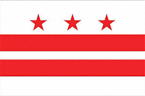
Flag of the District of Columbia
Source: Federal Flags
The flag of the District of Columbia (Washington, D.C.), adopted by the Council of the District of Columbia in 1938, is a bold yet simple design inspired by George Washington's family coat of arms. The flag design includes two horizontal red bars and three red five-pointed stars on a white background.
The flag stands as a symbol of Washington's heritage and the nation's founding. Although it is a straightforward design, it represents deep and understated meaning in terms of patriotism, history, and unity.
History of the District of Columbia
The history of the District of Columbia starts with the U.S. Constitution, which allowed for a national capital to be away from the states. In 1790, Congress passed the Residence Act, which established the capital on the banks of the Potomac River.
Land was donated from both Maryland and Virginia, and in 1791, the federal district was officially called the "Territory of Columbia," with the city name "Washington," after President George Washington. Pierre Charles L'Enfant designed the layout of the city (which included wide avenues and ceremonial spaces).
In 1800, the federal government moved there from Philadelphia. In 1846, the portion of the district that came from Virginia was returned, and the boundaries formed as they are today.
Geography of the District of Columbia

Source: World Map
Washington, D.C. is located on the east coast of the United States, bordered by the state of Maryland to the north, east, and west, and the state of Virginia to the south across the Potomac River. It is one of the smallest federal jurisdictions in the country, with a total land area of around 68 square miles.
The most significant natural feature is the Potomac River, which forms the southwestern border of the city. The Anacostia River, a tributary of the Potomac and the other significant river in the District, flows through the eastern portion of the city. Generally, Washington, D.C. is flat, but it has gently rolling hills and low-lying areas.
Washington, D.C., is divided into four quadrants - Northwest, Northeast, Southwest, and Southeast - with the U.S. Capitol as the center. It retains its urban pattern of its original design by Pierre Charles L'Enfant, with wide avenues, parks, and public spaces.
Economy of the District of Columbia
In the District of Columbia, the economy is led by the strong presence of the federal government as the largest employer and largest force on the economy in D.C. with a multitude of residents working in various departments, agencies, contractors, and international organizations.
The federal presence also provides countless industries that support the federal government in areas like legal services, lobbying, public policy, and consulting. However, besides the federal government, D.C.'s private sector continues to grow in areas such as education, healthcare, and technology.
Hospitals, universities, and research institutions play a big role in contribution and innovation. There is also a large tourism revenue stream every year as millions come to see the National Mall, museums, memorials, and other sites.
Education in the District of Columbia
The education system in the District of Columbia is a priority from early childhood education onward. There is universal free pre-K for 3 to 4-year-olds. The DC K–12 education system is both traditional public schools and a robust network of public charter schools, serving nearly 100,000 students.
Graduation rates have improved, but faced challenges with low test scores and continuing achievement gaps, especially for minority and low-income students. There was a significant portion of students who lost learning due to the pandemic.
Therefore, the city invested funds into targeted programs, such as high-impact tutoring. The District is also home to many universities, such as Howard University, that provide significant educational and economic contributions to the City and region.


-1763365195776.jpg)
Comments
All Comments (0)
Join the conversation