When natural disasters happen, having fast and accurate information is really important to help people quickly. Numerous government agencies are collaborating to provide assistance in the wake of the recent July fourth floods. Mainly famous for launching rockets into space, NASA is one of them. NASA is assisting on Earth by using its specialised planes with advanced technology to aid local recovery efforts and search and rescue operations for Texas floods. These high-tech instruments, first made for science and space research, are now being used to give helpful information during emergencies—often doing things that regular tools can’t. In this article, you’ll learn what NASA is and how it’s helping with the Texas floods using its advanced technology.
Read About- All About California- Flag, Map, Geography, History, Facts and Education
What is NASA?
The National Aeronautics and Space Administration, or NASA, is a federal organization in the United States that is primarily responsible for space exploration. Although NASA is best known for launching men into space, the agency also employs its cutting-edge technology to aid in times of natural catastrophe, such as floods and wildfires. NASA has more than 20 satellites that monitor the planet and assist in monitoring the climate, weather, and emergencies. This vital effort contributes to the safety of people and communities worldwide.
What is the specialized technology NASA is sending for Texas flood search?
In the wake of recent catastrophic floods in Texas, NASA has rapidly mobilized specialized aircraft and advanced sensor technology to support critical search and recovery operations. Due to persistent cloud cover hindering traditional satellite imagery, NASA deployed airborne assets to gather essential data. All data collected from these aircraft and sensors is shared directly with emergency response teams, including FEMA and the Texas Division of Emergency Management, via the NASA Disasters Response Coordination System and the NASA Disasters Mapping Portal, ensuring rapid delivery for decision-making.
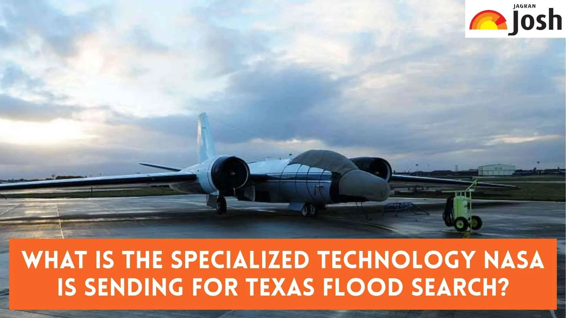
High-Altitude Imaging with WB-57 and DyNAMITE
One key component of this Nasa technology deployment is the WB-57 high-altitude aircraft. This aircraft is equipped with the DyNAMITE (Day/Night Airborne Motion Imager for Terrestrial Environments) sensor system. Departing from Ellington Field in Houston, the WB-57 conducts aerial surveys, capturing high-resolution video mosaics of the affected regions, particularly around the Guadalupe River. This imagery is vital for assessing damage and coordinating ground-based recovery efforts in real-time, significantly enhancing situational awareness for emergency teams.
Cloud-Penetrating Radar with Gulfstream III and UAVSAR
Additionally, NASA's Gulfstream III aircraft is flying from the Armstrong Flight Research Center, carrying the Uninhabited Aerial Vehicle Synthetic Aperture Radar (UAVSAR) system. Managed by the Jet Propulsion Laboratory, UAVSAR is particularly crucial because it can penetrate dense cloud cover and even vegetation to detect standing water that optical sensors might miss. This capability allows teams to precisely map the extent of flooding and evaluate damage within impacted communities, including the Guadalupe, San Gabriel, and Colorado river basins.
Must Read- What does Nvidia do? Check History, Company’s Leadership, and Artificial Intelligence
Conclusion
The deployment of NASA's specialized aircraft and cutting-edge Nasa technology, including the WB-57 with its DyNAMITE sensor and the Gulfstream III with UAVSAR, is proving invaluable in the ongoing Texas flood search and recovery efforts. By providing high-resolution, cloud-penetrating data, NASA is directly assisting ground teams in damage assessment, search operations, and resource allocation. This collaborative effort underscores the critical role of advanced scientific capabilities in responding to natural disasters and mitigating their devastating impact.


Comments
All Comments (0)
Join the conversation