Headlines about Hurricane Lorena are popping up as it is now a Category 1 storm moving along Mexico's Baja California Peninsula. This storm, resembling an eastern Pacific storm, brings heavy rain, strong winds, and flooding in coastal areas. It is likely to weaken as it moves inland, but its effects of moisture, rainfall, and wind will extend far beyond where the center of Lorena is found.
All areas across Baja California Sur are under tropical storm watches or warnings, and residents should maintain alert for rip currents and mudslides. As well, through forecast pet modeling, Lorena's moisture remnants are expected to affect the southern U.S., especially Texas, raising the likelihood and magnitude of weekend rain and flooding across the U.S.
Overall, as the forecasts are updated and evolve, both Mexico andthe U.S. regions are going to be preparing for the weather changes coming down from this tropical system.
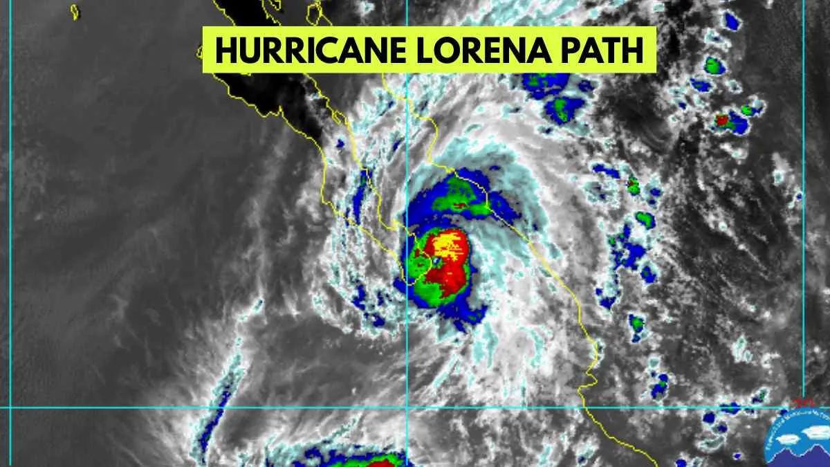
Hurricane Lorena Path & Forecast

As of now, Hurricane Lorena is located just off the southwest coast of Baja California Sur, about 115 to 165 kilometers (70-100 miles) west of Cabo San Lucas. It has strengthened into a Category 1 hurricane, with sustained winds around 75–80 mph (120-130 km/h) and stronger gusts reaching up to 150 km/h.
Lorena is moving northwest at roughly 16 mph (26 km/h) and is expected to continue following the coast, staying offshore for the next day or so. By Thursday night or early Friday, it is forecast to turn slightly eastward, weaken into a tropical storm, and potentially make landfall on the western Baja coast.
Rainfall Forecast & Flooding Risk from Hurricane Lorena
As Hurricane Lorena continues tracking along Mexico’s Baja California Peninsula, rainfall remains one of its most dangerous threats.
Mexico (Baja California Sur & Interior Regions)
Baja California Sur will likely experience 6 to 15 inches (150-380 mm) of rainfall through Friday. Isolated areas, especially in mountainous or poorly drained regions, could add even more to their totals, which creates an increased risk of:
-
Flash Flooding
-
Mudslides and Landslides
-
Road washouts and travel impacts
The Mexican authorities have issued flood alerts and mudslide alerts in La Paz, Todos Santos, and Los Cabos, among other areas.
United States (Texas & Desert Southwest).
Lorena is not forecasted to make landfall in the U.S., but the moisture will move into Texas, Arizona, and New Mexico this weekend.
Forecast models indicate:
-
1 to 3 inches of rain for central and southern Texas (with localized higher amounts).
-
A Level 1 excessive rainfall risk for the I-35 corridor, including San Antonio, Austin, and Dallas-Fort Worth.
There is a potential for urban flooding and saturated soil, especially where rain overlaps with existing areas.


Comments
All Comments (0)
Join the conversation