How is the Fujiwhara Effect Threatening the U.S. East Coast? The 2025 Atlantic hurricane season has shown increasing activity, with Tropical Storm Humberto and Invest 94L bringing new concerns for the U.S. East Coast. A rare weather phenomenon called the Fujiwhara Effect is now in play, where two tropical systems influence each other's path and strength by orbiting a common center within about 900 miles.
According to the National Hurricane Center (NHC), this dynamic interaction could result in altered storm trajectories, heightening the risk for coastal states from Florida to the Carolinas. Understanding the Fujiwhara Effect is crucial for residents to stay informed and prepared.
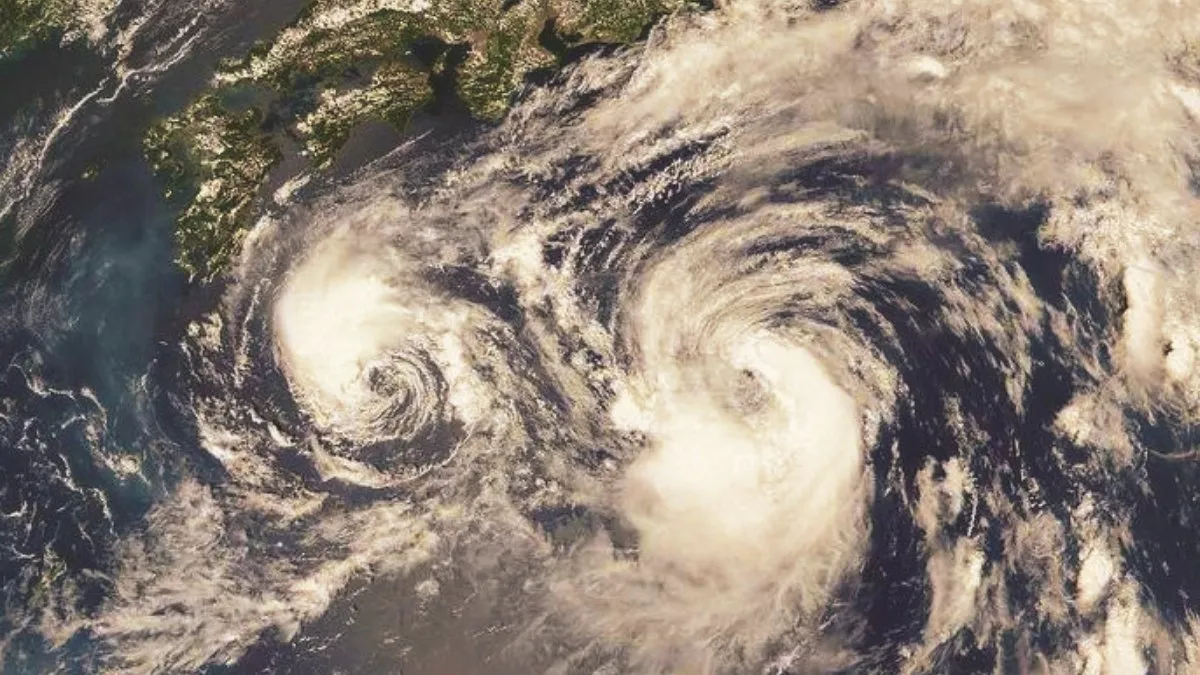
What is the Fujiwhara Effect Threatening the U.S. East Coast?
The Fujiwhara Effect describes the interaction in which two nearby storms rotate around a shared center, potentially affecting each other's paths and intensities.
-
Proximity of Humberto and 94L could cause their movements to become unpredictable, potentially bringing them closer to each other or altering their usual westward tracks.
-
This effect complicates forecasting and can increase the threat level to coastal areas, as the storms may either merge or intensify differently than if they were isolated systems.
| Storm | Current Status | Potential Strength | Approximate Location |
| Tropical Storm Humberto | Tropical Storm (45 mph winds) | Likely to become a major hurricane (Category 3 or higher) next week | Central Atlantic, about 480 miles east-northeast of the Northern Leeward Islands |
| Invest 94L | Tropical wave with a high chance of development (80%) | Likely to form into a tropical depression late this week, could become a tropical storm (next name is Imelda) | Near the Dominican Republic; expected to move toward the Bahamas |
What could be the impact on the U.S. East Coast?
Tropical Storm Humberto currently has sustained winds of 45 mph, while Invest 94L develops near the Dominican Republic with an 80% chance of becoming a tropical storm soon.
-
Coastal areas from Florida through the Carolinas may experience heavy rainfall leading to flooding risks.
-
Strong winds and high surf could affect shorelines, even if the storms remain offshore.
-
The interaction of the storms could change quickly, increasing forecast uncertainty and requiring ongoing attention from residents.
-
Emergency plans should be reviewed given the potential for sudden changes in storm intensity and direction.
How strong are storms Humberto and 94L currently?
Tropical Storm Humberto has sustained winds of 45 mph and is moving west-northwest at around 12 mph, with projections to strengthen into a hurricane within days. Invest 94L is showing signs of intensification, with an 80% probability of becoming a tropical storm named Imelda. These storms are close enough for the Fujiwhara Effect to influence their paths, adding complexity to their forecasted tracks. Meteorologists continue to monitor changes in strength and trajectory closely due to the potential impact on the U.S. East Coast.
Read Other U.S. News and Stories Here:
U.S. Firms Appoint Indian-Origin Leaders Amid H-1B Visa Fee Hike
Where Is Hurricane Erin Heading?
Tropical Storm Erin 2025: Current Status and Forecast
Conclusion
The Fujiwhara Effect between Tropical Storm Humberto and Invest 94L presents a rare and complex weather pattern during the 2025 Atlantic hurricane season. This interaction could lead to unpredictable storm paths and intensified impacts on the U.S. East Coast, increasing hazards such as flooding and wind damage. Staying updated with official forecasts and having thorough emergency preparations is critical for residents in vulnerable coastal regions as these storms evolve.


Comments
All Comments (0)
Join the conversation