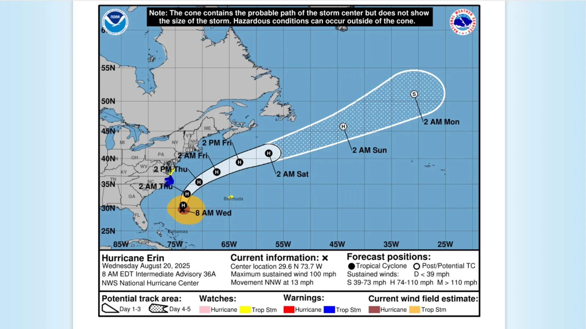
Hurricane Erin continues to churn in the Atlantic, with conditions along the U.S. coast expected to deteriorate Wednesday, Aug. 20, as the storm moves north-northwest, according to the 5 a.m. advisory from the National Hurricane Center. As of early morning, the center of Hurricane Erin was located about 450 miles east of Brevard County, Florida. Erin weakened slightly overnight but remains a strong Category 2 hurricane with maximum sustained winds near 100 mph. Forecasters are closely monitoring Erin’s projected path, warning of rough surf, dangerous rip currents, and hazardous conditions along much of the East Coast.
Officials in Dare County, North Carolina, have already declared a state of emergency as the hurricane the storm has already impacted Puerto Rico and the Virgin Islands, with a tropical storm warning in effect for the Turks and Caicos Islands, and its effects are expected to be felt along the U.S. East Coast from Florida to New England.
Read About- What are the Costliest Hurricanes in the U.S.? Check List!
Where is Hurricane Erin Going to Hit?
According to the latest Hurricane Erin tracker, the storm is a Category 2 hurricane with maximum sustained winds near 100 mph, located about 450 miles east of Brevard County, Florida, as of the 5 a.m. advisory on Aug. 20. Erin is moving north-northwest at around 10 mph, with forecast models showing its projected path turning northward into the open Atlantic and staying offshore. Potential impacts are expected along the East Coast, from Florida to the Outer Banks and beyond, including rough surf, strong rip currents, and hazardous coastal conditions.
Hurricane Erin Projected Path and Timeline (as of Aug. 20, 2025)
Check the breakdown of Hurricane Erin's projected path and timeline, showing its current strength, past development, and expected coastal impacts:
| Date | Location / Region | Status & Impact |
| Aug. 20–21 | Offshore Outer Banks, North Carolina (Dare County) | Projected to stay offshore but bring dangerous surf, rip currents, and erosion. |
| Aug. 20 | ~450 miles east of Brevard County, Florida | Weakened to Category 2 (100 mph winds); moving north-northwest, offshore. |
| Aug. 19 | South of Bermuda / Southeast of Cape Hatteras | Erin downgraded to Category 3–4 but remained a major hurricane offshore. |
| Aug. 18 | Open Atlantic (north of Hispaniola) | Erin peaked at Category 5 with 165 mph winds before beginning to weaken. |
| Aug. 17 | Turks and Caicos Islands (Warning Zone) | Strong winds and heavy rainfall; tropical storm warning remained in effect. |
| Aug. 16 | Near Puerto Rico & U.S. Virgin Islands | Outer rain bands brought heavy rain and gusty winds; tropical storm alerts issued. |
| Aug. 14–15 | Central Atlantic Ocean | Erin formed as a tropical storm and quickly strengthened into a hurricane. |
How Will Hurricane Erin Impact the U.S. East Coast Beaches and Surf?
Even without making direct landfall, Hurricane Erin will have a significant impact on the U.S. East Coast. The storm is expected to produce extremely dangerous surf and strong rip currents from August 18–21. While waves along the beaches will likely exceed 7 feet, the open Atlantic could see massive waves reaching more than 6 to 10 feet in height. Coastal flooding and erosion are also likely in vulnerable areas, creating hazardous conditions for residents and marine traffic. Hatteras Island Mandatory Evacuation and North Carolina Mandatory Evacuation orders have been released by Dare County Officials. Officials want to protect people from heavy surf and winds that could damage the main highway, highlighting the dangers of living on a vulnerable barrier island.
Hurricane #Erin and the #RipCurrent risk along the Atlantic coastline this week. Heavy Rainfall and flood potential for the upper Midwest through Monday. #HeatRisk continues and expands from the Mississippi Valley through Monday then into the Southwest and Intermountain West… pic.twitter.com/Bi3nMq3DTD
— National Weather Service (@NWS) August 17, 2025
Why Did Hurricane Erin Intensify So Rapidly Into a Category 5 Storm?
Erin strengthened from a tropical storm to a Category 5 hurricane in just over 24 hours, a rare case of rapid intensification hurricane behavior. Favorable conditions such as warm Atlantic waters, low wind shear, and its distance from land fueled this explosive growth. At its peak, Erin reached sustained winds of 160 mph, qualifying as one of the strongest storms ever recorded this early in hurricane season August, according to the Saffir-Simpson scale. By Today, however, Erin had weakened to a Category 4 hurricane, with maximum sustained winds near 140 mph, while still posing risks of flooding rains, rough surf, and dangerous rip currents.
Must Read- What Were the Biggest Takeaways From Trump and Putin’s Meeting? Explained!
Conclusion
The story of Hurricane Erin is one of rapid growth and widespread impact, even without a direct U.S. landfall. With hurricane spaghetti models showing Erin’s track offshore, Americans should focus on coastal safety, avoiding rip currents, and monitoring updated forecasts. The storm underscores how quickly conditions can change during the Atlantic hurricane season, making preparedness vital. From its strength to its path, Erin is a reminder of the power and unpredictability of nature.


Comments
All Comments (0)
Join the conversation