The Brahmaputra River System is one of the most significant river systems in Asia, originating from the Tibetan Plateau and flowing through northeastern India before merging with the Ganga in Bangladesh. It plays a crucial role in supporting millions of people by providing water for agriculture, drinking, and sustaining diverse ecosystems.
The Brahmaputra River is often regarded as the "lifeline" of Northeast India, flowing through Tibet, India, and Bangladesh. It plays a crucial role in agriculture, ecology, culture, and spirituality in the region. Unlike most rivers in India, which are associated with a feminine identity, the Brahmaputra is uniquely masculine, named after Brahma, meaning "Son of Brahma."
About Brahmaputra River
The Brahmaputra River spans across three countries—China, India, and Bangladesh. It passes through the Indian states of Arunachal Pradesh, Assam, Meghalaya, West Bengal, Nagaland and Sikkim, shaping the landscape and ecology of the region. The river is vital for agriculture, transportation, and hydroelectric power, making it a key economic and environmental asset.
The basin of the Brahmaputra is home to rich biodiversity, including endangered species such as the one-horned rhinoceros found in Kaziranga National Park. The river also serves as a crucial trade route and supports fishing, contributing to the livelihoods of many communities. However, due to its strong and unpredictable currents, the river often experiences devastating floods during the monsoon season, impacting the lives of those living along its banks.
What are the key features of the Brahmaputra River?
- Length: Approximately 2,900 km, making it one of the longest rivers in Asia.
- Basin Area: Covers nearly 1.18 million square kilometres across multiple countries.
- Hydropower Potential: The river supports several hydroelectric projects, helping generate clean energy.
- Cultural and religious importance: Considered sacred in Hinduism, the river is associated with various religious practices and festivals.
- Navigation and Trade: Acts as a major waterway for transportation and commerce between India and Bangladesh.
Geographical Overview
| Aspect | Details |
| Total Basin Area | 5,80,000 sq. km. (spread over Tibet, Bhutan, India, and Bangladesh) |
| Basin Area in India | 1,94,413 sq. km (5.9% of India's geographical area) |
| Longitude | 88°11’E to 96°57’E |
| Latitude | 24°44’N to 30°3’N |
| River Length | 2,900 km (916 km in India) |
| Origin | Kailash Range, Himalayas (Elevation: 5,150 m) |
| Flow Through States | Arunachal Pradesh, Assam, Meghalaya, Nagaland, West Bengal, Sikkim |
Basin Boundaries
- North: Himalayas
- East: Patkai Range (along the India-Myanmar border)
- South: Assam Hills
- West: Himalayas and the ridge separating it from the Ganga Basin
The course of the Brahmaputra River
Tibet (China)
- Originates as Yarlung Tsangpo.
- It flows through deep gorges in the Himalayas.
India
- Enters Arunachal Pradesh as Dihang.
- Joins Lohit and Dibang rivers near Sadiya.
- Known as Brahmaputra in Assam.
- Forms Majuli (largest river island) & Umananda (smallest river island).
Bangladesh
- Enters as Jamuna River.
- Joins Ganga to form the Sundarbans Delta.
Major Tributaries of the Brahmaputra River
.jpg)
Source:riversinsight
The Brahmaputra River has numerous tributaries, categorised into North and South bank tributaries:
| Tributaries from the North Bank (right bank) | Tributaries from the South Bank (Left Bank) |
| Jiadhal | Noa Dehing |
| Subansiri | Buridehing |
| Siang | Debang |
| Kameng (Jiabharali in Assam) | Dikhow |
| Dhansiri (North) | Dhansiri (South) |
| Puthimari | Kopili |
| Pagladiya | Digaru |
| Manas | Dudhnai |
| Champamati | Krishnai |
| Saralbhanga | |
| Aie | |
| Sankosh |
Additional Tributaries in West Bengal (Joining in Bangladesh)
- Teesta
- Sankosh
- Raidak-I
- Raidak-II
- Torsa
- Jaldhaka
Major Rivers in the Brahmaputra Basin
(A) Siang River
- Principal tributary of the Brahmaputra.
- Known as Yarlung Zangbo in Tibet.
- Origin: Kailash Range (Himalayas, Elevation: 5,300 m).
- Length: 1,600 km in Tibet, 230 km in Arunachal Pradesh.
- Merges with Lohit and Dibang near Pasighat to form the Brahmaputra.
(B) Subansiri River
- Origin: Tibet.
- Length: 442 km (192 km in Arunachal Pradesh, 190 km in Assam, rest in Tibet).
(C) Kameng (Jiabharali) River
- Origin: Himalayas (Tibet territory beyond Aka & Duffa Hills).
- Length: 250 km (190 km in Arunachal Pradesh, 60 km in Assam).
(D) Dhansiri (South) River
- Origin: Laishiang Peak, Nagaland.
- Length: 354 km (flows through Nagaland and Assam).
(E) Buridehing River
- Origin: Patkai Ranges.
- Length: 362 km.
- Fertile plains covered with tea gardens.
(F) Kopili River
- Origin: Saipong Reserve Forest, Meghalaya.
- Length: 256 km (78 km on the Meghalaya-Assam border, 178 km in Assam).
(G) Manas River
- Origin: Bhutan, Himalayas.
- Catchment Area: 34,160 sq. km.
- Boundaries: Bhutan Hills (North), Pohumara River Basin (East), Champamati River Basin (West), Brahmaputra River (South).
Contribution to Water Resources
Stretching approximately 2,900 kilometres, the Brahmaputra originates in the Tibetan Himalayas as the Yarlung Tsangpo enters Arunachal Pradesh and flows through Assam before reaching Bangladesh. Covering a basin area of nearly 580,000 square kilometers, it sustains diverse ecosystems and millions of people
State-wise Drainage Area
| State | Drainage Area (sq. km.) |
| Arunachal Pradesh | 81,424 |
| Assam | 70,634 |
| West Bengal | 12,585 |
| Meghalaya | 11,667 |
| Nagaland | 10,803 |
| Sikkim | 7,300 |
| Total | 1,94,413 |
Physiography and Soil
- Upper Basin (Arunachal Pradesh, Nagaland): Mountainous terrain and narrow valleys.
- Middle Basin (Assam, Meghalaya, West Bengal): Hills, forests, tea gardens, and fertile plains (Cooch Behar, West Dinajpur).
- Soil Types:
- Red loamy soil (predominant)
- Alluvial soil (fertile, found in Assam and West Bengal)
- Sandy, loamy, clayey soils
- Laterite soils
- Culturable Area: 12.15 million hectares (6.2% of India’s total culturable area)
What are the different key contributions of the Brahmaputra river in the North-East region?
| Aspect | Description |
| Agriculture | The river supports the cultivation of rice, tea, and jute in the fertile plains. Despite its annual floods, which can be destructive, they replenish the soil with nutrients, making the region highly productive. |
| Hydroelectric Potential | The river has vast hydroelectric potential, with ongoing efforts to harness clean energy for Northeast India and neighbouring countries. |
| Fishing and Biodiversity | Home to species like the Gangetic dolphin and migratory birds, the Brahmaputra is crucial for fishing-based livelihoods and biodiversity conservation. It also supports Kaziranga National Park, a UNESCO World Heritage Site. |
| Flood Control Challenges | While flooding sustains agriculture, it also causes displacement, soil erosion, and crop damage, emphasising the need for sustainable water management policies. |
What is the cultural significance of the Brahmaputra River?
The Brahmaputra is deeply woven into the culture, traditions, and religious practices of Northeast India. It symbolises spirituality, identity, and sustenance.
Cultural and Religious Aspects
- Bihu Festival: The Brahmaputra is central to Bihu, Assam’s most important festival marking the beginning of the agricultural season and the Assamese New Year.
- Majuli Island: A Religious Hub: The world’s largest river island, Majuli, is a prominent centre of Vaishnavite culture with monasteries (Satras) that preserve Assamese art and traditions.
- Mythological Significance: The Brahmaputra’s masculine identity stems from Hindu mythology, where it is considered the "Son of Brahma," embodying power, strength, and resilience.
Why is the Brahmaputra considered masculine?
Unlike most rivers in India, which are revered as feminine (e.g., Ganga, Yamuna), the Brahmaputra represents masculine energy, characterised by its unpredictable floods, powerful currents, and landscape-shaping force.
Key Differences
| Feminine Rivers (e.g., Ganga) | Masculine River (Brahmaputra) |
| Symbolize nurturing and life-giving qualities | Represents power, strength, and dynamism |
| Worshiped as mothers or goddesses | Seen as the "Son of Brahma" |
| Gentle and sustainable flow | Fierce and unpredictable floods |
Different Names of Brahmaputra River
| Region | Name |
| Tibet | Tsangpo (The Purifier) |
| China | Yarlung Zangbo, Jiangin |
| Assam Valley | Dihang (Siang), Brahmaputra (after Sadiya) |
| Bangladesh | Jamuna River |
| After Ganga Confluence | Padma River |
| After Padma-Meghna Confluence | Meghna River |
How many states through which Brahmaputra River Flows?
The Brahmaputra River flows from six Indian states, which are Arunachal Pradesh, Assam, Meghalaya, Nagaland, West Bengal and Sikkim.
Major Cities on the Brahmaputra River
- Dibrugarh
- Pasighat
- Neamati
- Tezpur
- Guwahati (largest urban center)
Hydropower Projects on the Brahmaputra River
| State | Hydropower Projects |
| Arunachal Pradesh | Tawang, Subansiri, Ranganadi, Paki, Papumpap, Dhinkrong, Upper Lohit, Damway, Kameng |
| Sikkim | Rangit Hydel Project, Teesta Hydel Project |
| Assam | Kopili Hydel Project |
| Meghalaya | New Umtru Hydel Project |
| Nagaland | Doyang Hydel Project |
| Manipur | Loktak, Tipaimukh Hydel Projects |
| Mizoram | Tuibai, Tuirial, and Dhaleshwari Hydel Projects |
What are the challenges and future possibilities for the Brahmaputra River?
Despite its importance, the Brahmaputra faces serious environmental and human-induced threats:
Challenges
- Climate Change: Himalayan glacier melt is affecting the river’s flow and seasonal patterns.
- Deforestation and Urbanisation: Encroachments and industrial pollution threaten the river’s biodiversity.
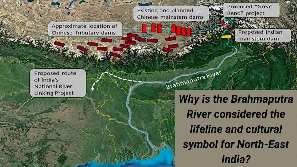
- Transboundary Water Disputes: China’s upstream activities, including dam construction, raise concerns over India’s water security.
Sustainable Solutions
- Integrated Flood Management: Developing early warning systems and better infrastructure to reduce damage.
- Eco-friendly Development: Promoting hydroelectric projects with minimal environmental impact.
- Regional Cooperation: Strengthening India-Bangladesh-China water-sharing agreements for sustainable management.
Conclusion
The Brahmaputra River is more than a waterway; it is a symbol of resilience, culture, and spiritual reverence in Northeast India. Its masculine identity sets it apart from other rivers, reflecting its powerful yet life-sustaining nature. As a lifeline for millions, ensuring its ecological and cultural preservation is vital for future generations.


Comments
All Comments (0)
Join the conversation