The National Aeronautics and Space Administration is targeting to launch US-European ocean-monitoring satellite - Sentinel-6- on November 21, 2020. The satellite would be launched aboard Falcon 9 rocket from Vandenberg Air Force Base in California.
This was shared by the head of NASA's human spaceflight program, Kathy Lueders through a series of tweets. Lueders posted saying that SpaceX would be replacing two engines in total on the rocket’s first stage after testing and hardware inspections.
She continued by saying work is now progressing to implement the engine change and all engine hardware replacements will finish next week.
.@SpaceX is replacing two engines in total on the rocket’s first stage after testing and hardware inspections. 2/3
— Kathy Lueders (@KathyLueders) November 3, 2020
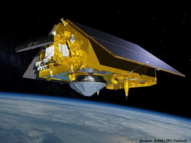
Sentinel-6 ocean-monitoring satellite: All you need to Know!
Objective
The Sentinel-6 Michael Freilich satellite will accurately measure extremely small variations in sea level and monitor the height of the ocean for nearly the entire globe. The ocean-monitoring satellite will mainly rely on a suite of three instruments that will provide scientists information to determine the spacecraft's exact position in orbit.
Key Instruments
1. Laser retroreflector array: The instrument is a set comprising nine small, precisely shaped mirrors. Lasers will be directed at them from ground stations on Earth and they will reflect the harmless beams right back to their point of origin. The laser-emitting ground stations will then calculate the time the laser takes to bounce off the reflectors and return. This will give them the distance between the satellite and the station.
2. Global Navigation Satellite System: The precise Orbit Determination (GNSS-POD) will track GPS and Galileo navigation signals. The researchers will analyze these signals to help determine the satellite's position.
3. Doppler Orbitography and Radioposition Integrated by Satellite (DORIS): This will analyzes radio signals from 55 global ground stations to determine the 3D position of the satellite over time. When used together, these instruments will provide the required data to ascertain the precise position of the satellite, which will in turn help determine the height of the sea surface.
Other Scientific Instruments
Poseidon-4 radar altimeter: The instrument is capable of measuring the height of the ocean by bouncing radar pulses off the water's surface and calculating the time the signal takes to return to the satellite.
Advanced Microwave Radiometer for Climate (AMR-C): The instrument will measure the amount of water vapor between the spacecraft and the ocean, as water vapor in the atmosphere can affect the propagation of the radar pulses from the altimeter, which may make the ocean appear higher or lower than it actually is. This instrument will correct that.
These two instruments together will help determine the height of the sea level.
Significance
The new ocean monitoring satellite will continue the decades-long watch over our global ocean and help us better understand the impact of climate change on our planet, especially the oceans, as our planet is changing and the ocean is rising.
Sentinel-6B |
| A second identical spacecraft Sentinel-6B will be launched in 2025 to continue the work after the first satellite's five-and-a-half-year prime mission ends. The satellites are a part of the Sentinel-6/Jason-CS (Continuity of Service) mission, which has been undertaken by NASA in partnership with the European Space Agency (ESA), National Oceanic and Atmospheric Administration (NOAA) and the European Organisation for the Exploitation of Meteorological Satellites (EUMETSAT). Impact The two satellites - Sentinel 6 & Sentinel 6-B- will together add a decade's worth of most accurate satellite data yet on ocean height to a nearly 30-year record documenting how our oceans are rising in response to climate change. Both spacecraft will also collect data on atmospheric temperature and humidity. This will help improve weather forecasts as well as atmospheric and climate models. |


-1766578349393.jpg)
-1766576965412.png)
-1766571314890.jpg)
Comments
All Comments (0)
Join the conversation