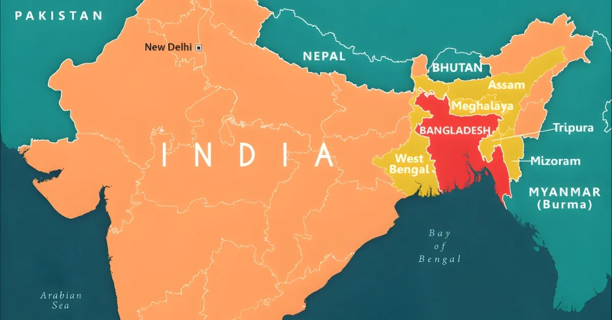
India is a vast country with many borders. It has a land border of about 15,106.7 kilometers and a coastline of 7,516.6 kilometers. These borders touch land and sea, connecting India to many neighboring countries. India shares its land borders with seven countries: Afghanistan, Bangladesh, Bhutan, China, Myanmar, Nepal, and Pakistan. It also has maritime borders with Sri Lanka, Maldives, and Indonesia. Among these, Bangladesh shares one of the longest borders with India. This border stretches across plains, rivers, and hills. But do you know how many Indian states actually touch Bangladesh? It’s more than you might think. In this article, we’ll take a look at the Indian states that share their border with Bangladesh. We’ll explore where these borders lie and why they matter.
Which States of India share boundaries with Bangladesh?
India shares its longest international border with Bangladesh, stretching approximately 4,096.7 kilometres. This border touches five Indian states, each contributing to the geographical and cultural connection between the two countries. Here are the Indian states that share boundaries with Bangladesh:
- West Bengal – Shares the longest stretch, about 2,216.7 km
- Assam – Shares around 263 km
- Meghalaya – Shares about 443 km
- Tripura – Shares approximately 856 km
- Mizoram – Shares around 318 km
These states lie mostly in the eastern and northeastern parts of India. The border includes rivers, hills, and plains, making it diverse and complex. It plays a key role in trade, migration, and regional cooperation.
1. West Bengal
West Bengal shares the longest border with Bangladesh. The boundary stretches over 2,200 kilometres, covering rivers, plains, and hills. This border plays a major role in trade and cultural exchange. Several districts like North 24 Parganas, Murshidabad, and Malda lie along this border. The region is rich in history and has strong ties with Bangladesh.
2. Assam
Assam shares a smaller but important border with Bangladesh. The boundary runs through the southwestern part of the state. It includes riverine areas and low-lying plains. This region is known for its natural beauty and biodiversity. The border also influences local trade and migration.
3. Meghalaya
Meghalaya shares a long and hilly border with Bangladesh. The boundary passes through thick forests and rolling hills. It covers districts like East Khasi Hills and West Jaintia Hills. The region is known for its scenic beauty and tribal culture. Cross-border trade and tourism are growing in this area. Meghalaya’s border with Bangladesh is peaceful but remote.
4. Tripura
Tripura shares a significant border with Bangladesh, covering nearly 856 kilometres. The boundary surrounds the state on three sides. This makes Tripura one of the most connected Indian states with Bangladesh. The border includes plains, rivers, and small hills. Trade and cultural exchange are strong here. Several border towns have close ties with Bangladeshi counterparts.
5. Mizoram
Mizoram shares a short but strategic border with Bangladesh. The boundary lies in the southwestern part of the state. It passes through forested hills and remote villages. The terrain is rugged and less populated. Mizoram’s border with Bangladesh is important for security and connectivity. Efforts are being made to improve infrastructure and trade links.

-1751903714262.png "GK Quiz on Environment and Biodiversity")

-1763833781919.jpg)

Comments
All Comments (0)
Join the conversation