
The NISAR satellite, a joint mission between NASA and the Indian Space Research Organisation (ISRO), is set to launch soon, marking a new era in Earth observation. By utilizing advanced Synthetic Aperture Radar (SAR) technology, NISAR will provide high-resolution images of the Earth's surface, tracking subtle changes like ground movements, glacier shifts, and deforestation, all with extreme precision.
This game-changing mission will allow scientists to monitor nearly all of Earth’s solid surfaces twice every 12 days. It will not only provide real-time data on natural disasters like earthquakes but also help track environmental changes and provide valuable insights into climate change and disaster management.
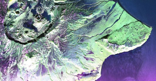
Source : NASA/JPL-Caltech
What Makes NISAR’s Synthetic Aperture Radar (SAR) Technology So Powerful?
NISAR’s SAR technology is key to its incredible precision. Traditional radar satellites often face resolution challenges due to antenna size.
However, SAR allows NISAR to deliver detailed images of Earth’s surface without needing oversized antennas.
| Feature | Traditional Radar | NISAR with SAR |
| Antenna Size | Large, difficult to deploy and operate in space | Compact, deployable 39-foot (12 meters) antenna |
| Resolution | Limited by antenna size | High-resolution images down to fractions of an inch |
| Data Processing | Lower precision due to limited data collection | Uses Doppler shift to refine and focus images |
| Mapping Frequency | Less frequent | Provides updates every 12 days across the globe |
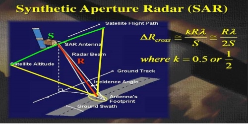
Source : edfuturetech
What are the Benefits of SAR?
- High-Resolution Imaging: Captures ultra-detailed images of Earth’s surface.
- Day and Night Capability: Operates continuously, unaffected by time or weather.
- Penetration Through Clouds: Can see through clouds and detect changes even during adverse weather conditions.
How NISAR’s SAR Technology Will Transform Earth Science?
NISAR’s SAR system is designed to collect vast amounts of data that reveal changes in the Earth’s surface. Here’s how it works:
- Radar Pulses: NISAR emits microwave pulses toward Earth’s surface.
- Signal Echoes: When the pulses hit the surface, they bounce back to the satellite, providing valuable data.
- Data Processing: The Doppler shift in the returning signals allows for fine-tuned processing, creating high-resolution images of the surface.
What are the Applications of NISAR which helps in Tracking Earth's Dynamic Systems?
NISAR will track Earth’s surface changes with exceptional detail, providing data on:
- Natural Disasters: Monitoring earthquakes, tsunamis, and volcanic activities.
- Glacial Movements: Observing the shifts in glaciers and ice sheets to understand climate change.
- Deforestation and Ecosystem Changes: Mapping forest growth and loss, as well as tracking flood zones.
Here’s a look at the major applications NISAR will support:
| Application | What NISAR Will Track | Scientific Significance |
| Earthquakes | Ground deformation before and after seismic events | Helps in understanding fault movements and assessing earthquake risks |
| Glacier Movements | Shifts in glaciers and ice sheets | Vital for studying ice dynamics and their impact on sea levels |
| Forest Changes | Deforestation and forest growth | Critical for monitoring biodiversity and environmental health |
| Floods and Land Shifts | Mapping changes in land elevation and water movement | Improves flood management and disaster response strategies |
Why Will NISAR Change Earth Science Forever?
NISAR will offer an unprecedented level of monitoring, providing scientists with tools to study Earth’s dynamic systems in real-time. By imaging vast areas at high resolution, the satellite will:
- Detect small changes in land surfaces
- Help monitor and predict natural hazards
- Offer essential data for disaster preparedness, recovery, and environmental protection
What is the Role of NASA and ISRO in Advancing Earth Science with NISAR?
This NASA-ISRO collaboration is a landmark achievement, merging decades of expertise from both space agencies. It opens up a world of possibilities for international cooperation in addressing climate change, monitoring natural disasters, and supporting sustainability efforts globally.
As we face a changing climate and increasing natural disasters, the data gathered by NISAR will be crucial in shaping our response strategies and understanding the impact of environmental changes.
Image Credit: linkedin/ Aakash Nagpal
Conclusion: NISAR—The Key to a More Resilient and Sustainable Planet
The NISAR satellite is set to revolutionize our understanding of Earth’s dynamic systems. With its cutting-edge radar technology, it will provide detailed, real-time data on everything from earthquakes to deforestation. By collaborating with ISRO, NASA is helping advance global Earth science and sustainability initiatives, making NISAR an essential tool for monitoring our planet's changing landscape.
Read| GJ 1214 b: A Mysterious ‘Super-Venus’ Exoplanet Unveiled by NASA’s James Webb Space Telescope
Read| Who is Janet Petro? Meet the First Woman to Lead NASA as Acting Administrator
Read| List of Administrators of NASA
Read| How Light Pollution Is Threatening the Very Large Telescopes in Chile: An Expert’s Warning


-1766337791473.jpg)


Comments
All Comments (0)
Join the conversation