Africa is undergoing a gradual geological transformation, with tectonic forces slowly pulling the continent apart. This process, driven by movements along the East African Rift System, is separating Africa into two parts: the Nubian and Somalian plates. According to researchers, Africa might eventually break into two separate landmasses due to the formation of a new ocean over millions of years. This ongoing tectonic activity mirrors the planet's ancient shifts, continuing to reshape the African landscape in the distant future.
Source: thetravel
As the continent’s two major sections continue to drift apart, a new body of water could emerge, possibly giving landlocked nations like Uganda and Zambia coastlines in the far future.
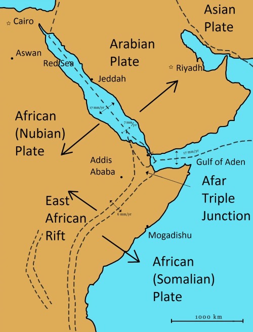
The East African Rift, which appeared as a 35-mile-long crack in Ethiopia's deserts in 2005, is the first indication of this process. Seismic data published in Geophysical Research Letters suggests that the rift’s formation is driven by tectonic activities similar to those happening in oceanic rift zones. This crack marks the boundary of three tectonic plates—the African Nubian, African Somali, and Arabian plates—that have been slowly pulling away from each other.
Christopher Moore, a doctoral student at the University of Leeds, noted, “This is the only place on Earth where you can observe how a continental rift evolves into an oceanic rift.” Similar tectonic movements are responsible for the creation of the Red Sea and the Gulf of Aden, which separate East Africa from Western Asia.
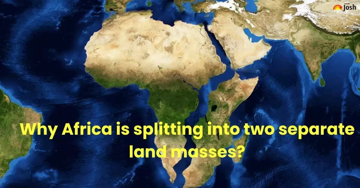
Why is Africa Splitting Into Two Continents?
The process of Africa splitting into two continents is due to the geological phenomenon known as continental rifting. This process is occurring along the East African Rift System (EARS), a tectonic plate boundary where the African Plate is being pulled apart. The East African Rift is causing the continent to split, with tectonic plates like the Nubian and Somalian moving apart. Over 5-10 million years, this will create a new ocean, reshaping East Africa's geography, and trade routes, and presenting both opportunities and challenges
Here's a brief explanation:
| Aspect | Details |
| Phenomenon | Tectonic rifting along the East African Rift |
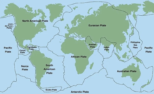
| Major Tectonic Plates Involved | Nubian African Plate, Somalian African Plate, Arabian Plate |
| Timeframe | 5-10 million years for a new ocean to form |
| Affected Countries | Ethiopia, Kenya, Somalia, Tanzania, Uganda, Zambia |
| Opportunities | New coastlines, trade routes, economic development |
| Challenges | Displacement of communities, environmental changes, increased seismic activity |
Source: thetravel
Impact of the Rift Formation
- Geographical Changes: New land masses like Somalia, Kenya, and Tanzania will eventually separate from mainland Africa. Formation of a New Ocean will occur i.e. sixth ocean will emerge in the newly created space. It will Redraw the Borders Countries like Uganda and Zambia could gain coastlines.
- Economic and Trade Implications: Landlocked nations gaining coastal access could boost international trade. New shipping routes will alter global commerce. Coastal cities will need to adapt to rising sea levels and infrastructure changes.
- Environmental and Ecological Effects: Creation of new marine ecosystems, affecting biodiversity.Potential for volcanic eruptions and earthquakes due to tectonic shifts. Freshwater sources may be altered, impacting agriculture and human settlements.
- Human and Political Impact: Migration due to land instability and coastal changes.Geopolitical shifts as nations gain or lose strategic coastal areas. Governments must prepare for disaster management and infrastructure development.
Pangea: The Ancient Supercontinent and the Role of Tectonic Plates
Pangea: The Ancient Supercontinent
Before Plate Tectonics arrived and different collisions occurred, Pangea a supercontinent existed. Let’s see in detail about Pangea, its formations & geography and what is the relevance of Tectonic in breaking the Pangea.
Source: Britanica
About Pangea:
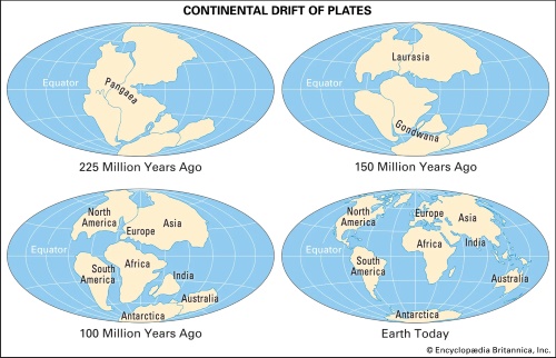
Pangea, a vast supercontinent in Earth's distant past, included nearly all of the planet’s landmasses. It was surrounded by a massive ocean, Panthalassa. By the Early Permian Epoch, approximately 299 to 273 million years ago, Pangea was fully formed, only to begin disintegrating about 200 million years ago, during the Early Jurassic Epoch. This breakup eventually led to the formation of today’s continents and oceans. The idea of Pangea was introduced by German meteorologist Alfred Wegener in 1912 as part of his theory of continental drift. The name Pangea originates from the Greek word Pangea, meaning "all Earth."
Formation of Pangea:
The process of assembling Pangea’s landmasses was well underway by the Devonian Period (419.2 to 358.9 million years ago) when the cratons of Laurentia (North America's stable interior) and Baltica (Eastern Europe’s stable interior) collided with smaller microcontinents to form Euramerica. By the start of the Permian Period (298.9 to 252.2 million years ago), the northern coastline of Gondwana (a precursor to modern continents such as South America, Africa, India, and others) joined with Euramerica’s southern portion. When Siberia’s Angaran craton merged with this landmass during the Early Permian, the assembly of Pangea was complete.
Geography of Pangea:
Pangea had a C-shape, stretching between Earth’s polar regions. Its eastern edge contained the Tethys Sea, a significant oceanic feature that evolved into the Neo-Tethys Ocean after the Cimmerian continent detached from Gondwana. To the east, Cathaysia, a smaller landmass, extended into the eastern Panthalassic Ocean, housing parts of present-day North and South China. The surrounding oceans contained various microcontinents, volcanic arcs, and oceanic plateaus, all of which later joined Pangea’s edges.
The breakup of Pangea:
Pangea began to break apart approximately 200 million years ago, and this process is now understood through plate tectonics. The concept of plate tectonics, rather than Wegener’s original theory of continental drift, explains that Earth’s lithosphere is made up of large, rigid plates that move due to forces at oceanic ridges and subduction zones. As these plates spread apart, Pangea fragmented in stages, leading to the formation of new oceans like the Atlantic and Indian Oceans. By about 80 million years ago, the rift between North America and Europe, along with the breakaway of India from Madagascar, marked significant stages in the breakup process. The final major event was India’s collision with Eurasia, resulting in the creation of the Himalayas about 50 million years ago.
Major role of Plate Tectonics in breaking the Pangea:
Wegener’s early hypothesis on Pangea provided the foundation for the development of the theory of plate tectonics in the 1960s. Wegener noticed the similarities between the coastlines of South America and Africa, suggesting that these continents were once part of a single landmass that slowly drifted apart. His idea of continental drift evolved into a more comprehensive theory as scientists identified the mechanisms behind plate movements. In the 1930s, geologist Alexander L. Du Toit expanded on Wegener’s work by proposing the existence of two supercontinents: Laurasia in the north and Gondwana in the south.
Role of Tectonics in Africa's Rift Systems
The African Rift Systems, primarily the East African Rift System (EARS), are formed due to tectonic processes associated with divergent plate boundaries. The movement of the Earth's lithosphere in this region plays a crucial role in shaping the continent's topography and geological features.
What is a Tectonic Plate?
A tectonic plate, also known as a lithospheric plate, is an immense, irregularly shaped slab of solid rock, typically composed of both continental and oceanic lithosphere. The size of these plates can vary significantly, ranging from hundreds to thousands of kilometers across. Examples of the largest plates include the Pacific and Antarctic Plates. The thickness of the plates also varies considerably, from less than 15 km for young oceanic lithosphere to 200 km or more for ancient continental lithosphere, such as the interior regions of North and South America.
Source: worldAtlas
Understanding the Rift Process
The East African Rift is a major geological feature where the Earth's lithosphere (comprising the crust and upper mantle) is splitting due to tectonic forces. This process, known as rifting, occurs when a tectonic plate is divided into two or more smaller plates along divergent boundaries.
What is Rifting?
Rifting is the formation of a lowland area known as a rift valley. It is caused by movements in the Earth’s crust, leading to the gradual separation of landmasses. Similar tectonic activities in the past led to the formation of the Red Sea and the Gulf of Aden. The current East African Rift is an extension of these processes, eventually leading to a new ocean basin.
Key Tectonic Processes in African Rift Formation
- Divergent Plate Movement: The African Plate is splitting into the Nubian Plate (west) and the Somali Plate (east) due to mantle convection. This separation leads to extensional forces that create rift valleys.
- Normal Faulting and Rift Valley Formation: As the crust stretches, normal faults develop, causing large blocks of land to subside. This creates deep rift valleys, such as the Great Rift Valley.
- Volcanism and Magmatic Activity: Rift zones are associated with intense volcanic activity due to rising magma from the mantle. Notable volcanoes: Mount Kilimanjaro, Mount Kenya, and Nyiragongo. Active volcanoes like Erta Ale (Ethiopia) and Mount Nyiragongo (DR Congo) will continue to erupt as magma rises.
- Seismic Activity: The rifting process leads to frequent earthquakes, as faults shift to accommodate the stretching crust.
- Formation of Rift Lakes: Subsidence due to rifting leads to the formation of lakes, such as Lake Victoria, Lake Tanganyika, and Lake Malawi.
- Future Continental Breakup: If rifting continues, the Horn of Africa may eventually separate from the main African continent, forming a new ocean basin.
- Formation of a New Ocean Basin: If the rift continues to widen over millions of years, seawater will eventually flood in, forming a new ocean. A similar process created the Red Sea and the Atlantic Ocean when the African and South American continents separated.
Conclusion
The splitting of the African continent and the formation of a new ocean is a fascinating geological process with profound implications. While it may take millions of years to materialize, the transformation will reshape economies, ecosystems, and settlements. As researchers continue to study these changes, it is crucial to prepare for both the opportunities and challenges that come with the dynamic forces of nature.


Comments
All Comments (0)
Join the conversation