Key Points
- CBSE Class 12 Geography Exam is scheduled for February 24, 2025.
- Expert-curated sample paper covers key topics and follows CBSE's latest exam pattern.
- Sample paper designed for last-minute revision and to boost exam confidence.
CBSE Class 12th GEOGRAPHY Board Exam 2025: CBSE Class 12 Geography Exam is scheduled for February 24, 2025 (Monday), and with just one day left, it is crucial for students to practice important questions and brush up on key concepts for a high score. To help you maximize your score, our team of subject experts has prepared a high-quality sample paper based on important topics and the latest exam pattern. This sample paper is different from the one released by CBSE and is designed to give you an edge in the exam.
Key features of Sample Paper by experts are:
- Covers all key topics expected in the exam
- Follows CBSE’s latest question pattern for 2025
- Designed by expert teachers with years of experience
- Boosts confidence and enhances time management skills
- Perfect for last-minute revision and self-assessment
- So, check and download the expert-curated sample paper now and give your preparation the final push!
CBSE Class 12 Geography Sample Paper 2025 By Experts
Section-A MCQ’s
1. There are 3 statements given. Read them carefully and answer the following question.
(i) International trade is mutually beneficial if it leads to regional specialisation and higher production.
(ii) International trade can be detrimental if it leads to dependence, uneven development, and exploitation.
(iii) Global trade cannot impact the environment, health, and well-being.
Options:
(a) i, ii, and iii are true
(b) i and ii are true but iii is false
(c) All statements are false
(d) Only i is true
2. Katanga-Zambia region of Africa is densely populated due to:
(a) Pleasant climate
(b) Urbanisation
(c) Availability of minerals
(d) Availability of water
3. Which of the following carries 40% of the road traffic?
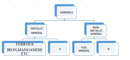
(a) Rural Road
(b) National Highway
(c) State Highway
(d) District Road
4. Aden, Honolulu, and Singapore are classified as:
(a) Oil Ports
(b) Packet Station
(c) Ports of Call
(d) Naval Ports
5. Complete the following table by choosing the correct option:
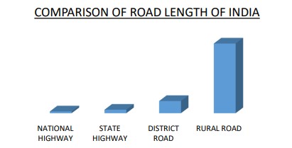
| A | B |
| Bauxite | Coal |
| Limestone | Copper |
| Copper | Limestone |
| Graphite | Mica |
6. Which one is the smallest unit of manufacturing?
(a) Cottage Manufacturing
(b) Small Scale Manufacturing
(c) Footloose Industries
(d) Agro-factories
7. In 2014-15, which category of land use saw the highest increase compared to 1950-51?
(a) Forest
(b) Barren land
(c) Culturable waste land
(d) Area under non-agricultural use
8. Which organization proposed the 'Basic Needs Approach'?
(a) International Labour Organization
(b) United Nations Development Programme
(c) World Health Organization
(d) International Monetary Fund
9. Identify the level of human development from the given characteristics:
- Rapid improvement in human development scores
- High social diversity
- History of political instability and uprisings
(a) Very high level
(b) High level
(c) Medium level
(d) Low level
10. Which stage of the Demographic Transition Model is characterized by high birth rates and declining death rates, leading to rapid population growth?
(a) Stage 1
(b) Stage 2
(c) Stage 3
(d) Stage 4
11. Arrange the following trade events in chronological order:
- Trade on the Silk Route (Rome-China)
- Slave trade emerged
- Trade between Europe and Asia expanded
- Trade growth after the Industrial Revolution
- Industrial nations became each other’s key customers
(a) 1,2,3,4,5
(b) 1,3,2,4,5
(c) 3,1,2,4,5
(d) 3,1,2,5,4
12. In which year was the Konkan Railway constructed?
(a) 1997
(b) 1999
(c) 1998
(d) 1996
13. There are four distinct phases of population growth identified in India over the last century. Identify the phase from the given description.
The growth rate of the country’s population though remained high, has started slowing down gradually. A downward trend in the crude birth rate is held responsible for such population growth. This was in turn affected by an increase in the mean age at marriage, improved quality of age at marriage, and improved quality of life particularly the education of females in the country. The growth rate of population is however still high in the country.
(a) Phase I (1901- 1921)
(b) Phase II (1921- 1951)
(c) Phase III ( 1951-1981)
(d) Phase IV (1981 to till present)
14. What has led to an increase in the concentration of arsenic in some parts of Bihar and West Bengal?
(a) Due to excessive water loss
(b) Due to less water extraction
(c) Due to heavy rainfall
(d) None of these
15. There are two statements marked as Assertion (A) and Reason (R). Mark your answer as per the codes provided below.
Assertion (A): The decline in one category usually leads to an increase in some other category of land use.
Reason (R): The reporting area has been relatively constant over the years.
(a) Both (A) and (R) are true but (R) is the correct explanation of (A)
(b) Both (A) and (R) are true but (R) is not the correct explanation of (A)
(c) (A) is true, but (R) is false.
(d) (A) is false, but (R) is true
16. Which of the following countries has developed high-yielding varieties of wheat and rice?
(a) Mexico and the Philippines
(b) Russia and Japan
(c) China and Australia
(d) Mexico and America
17. According to the World Development Report, in which year will India's population reach 1350 million?
(a) 2020
(b) 2025
(c) 2030
(d) 2035
Section-B (Source-Based Questions)
18. Study the given table and answer the following:
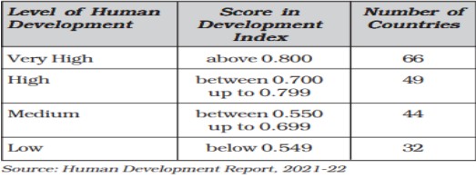
(i) What HDI score range corresponds to "high human development"?
(ii) Why might two countries with similar GDPs have different HDI rankings?
(iii) Give reasons for the low level of human development in 32 countries.
19. Read the passage carefully and answer the questions that follow :
Outsourcing or contracting out is giving work to an outside agency to improve efficiency and to reduce costs. When outsourcing involves transferring work to overseas locations, it is described by the term off-shoring, although both off-shoring and outsourcing are used together. Business activities that are outsourced include information technology (IT), human resources, customer support and call centre services and at times also manufacturing and engineering. Data processing is an ITrelated service easily be carried out in Asian, East European and African countries, in these countries IT skilled staff with good English language skills are available at lower wages than those in the developed countries. Thus a company in Hyderabad or Manila does work on a project based on GIS techniques for a country like the U.S.A. or Japan. Overhead costs are also much lower making it profitable to get job work carried out overseas, whether it is in India, China or even a less populous country like Botswana in Africa.
(a) What is outsourcing?
(b) Mention three regions where data processing is outsourced.
(c) Why are these regions preferred for outsourcing?
Section C (Short Answer Type Questions)
20. “Nature provides opportunities and human beings make use of these and slowly nature gets humanised”. Which concept of human geography is revealed by the given statement.
OR
In the early stages of their interaction with their natural environment, humans were greatly influenced by it”. Prove the statement.
21. Study the map given below and answer the following questions.
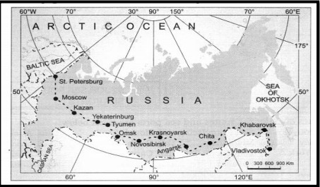
(a) Identify the railway line.
(b) Name the two terminal stations.
(c) Explain one economic significance of this railway.
22. Explain the objectives of the national youth policy adopted by the Government of India in 2014.
23. Explain the Naturalisation of Humans with the help of a real-life example.
Section-D (Long Answer Type Questions)
24. Discuss the major objectives of the Namami Gange Programme.
OR
"Land degradation caused by human-made activities is more harmful than natural causes in India." Explain and suggest solutions.
25. What steps have been taken for the development of the Bharmaur region? What were its social and economic consequences?
26. Define the Transport Network and explain the significance of Rhine Inland Waterways.
27. The largest slum, Dharavi, exhibits many contradictions. Explain.
OR
"Environmental pollution by solid waste is significant due to an enormous increase in waste quantity." Explain.
28. Discuss changing trends in India's imports and exports.
OR
Justify "International trade is an index of economic prosperity."
Section-E (MAP-BASED QUESTIONS)
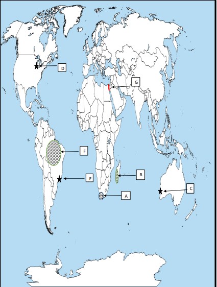
29. On the political map of the world, identify and label any 5 of the following:
- An area of extensive commercial grain farming.
- An area of Nomadic Herding.
- A major seaport in Australia.
- A major airport in North America.
- A major seaport of South America.
- An area of subsistence gathering.
- A major inland waterway
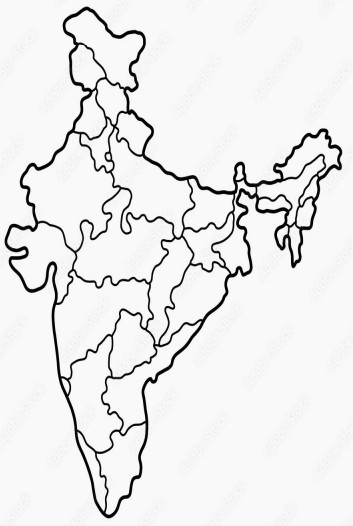
30. On the political map of India, locate and label any 5:
- (30.1) An international airport in Assam.
- (30.2 ) An Oil refinery in Gujarat.
- (30.3) The coal mine of West Bengal
- (30.4) The state leading in the production of Sugarcane.
- (30.5) The state with the highest population density.
- (30.6) An important bauxite mine in Madhya Pradesh.
- (30.7) An important seaport in Goa.
Other Related Links
Comments
All Comments (0)
Join the conversation