Pakistan new map: Pakistan released a new political map on August 4, 2020 laying claim to Indian territories of Jammu and Kashmir, Ladakh and parts of western Gujarat. India rejected the claim, terming it as 'political absurdity.'
The Indian Government in an official statement said that the so-called new political map of Pakistan is an exercise in political absurdity, laying untenable claims to territories in Gujarat and Union Territories of Jammu & Kashmir and of Ladakh.
India rejected the claim saying that the ridiculous assertions have neither legal validity nor international credibility. India slammed the move, saying that the new effort only confirms reality of Pakistan’s obsession with territorial aggrandisement supported by cross-border terrorism.
Which Indian territories are included in Pakistan's new map?
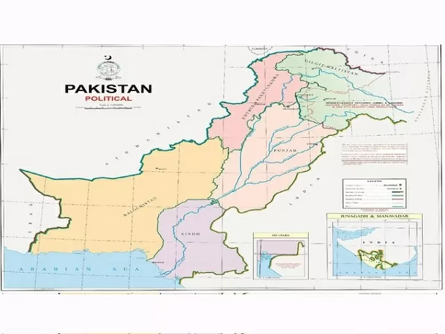
Pakistan's Prime Minister Imran Khan released the new political map of Pakistan on August 4, 2020. The new political map of Pakistan claims the Indian territories of Jammu and Kashmir, parts of Ladakh and parts of western Gujarat - Junagadh, Sir Creek and Manavadar.
Pakistan's new map: What does it include?
• The part of the Kashmir and Ladakh border with China has also not been marked in Pakistan's new map and has been described as "Frontier Undecided."
• The Line of Control has been extended to the Karakoram Pass in the map, showing Siachen as a part of Pakistan. The LoC has also been marked with a red dotted line.
Prime Minister @ImranKhanPTI unveiled the political map of Pakistan at an event earlier today. pic.twitter.com/6Iqj9YzX4K
— Prime Minister's Office, Pakistan (@PakPMO) August 4, 2020
• Further, a new political map of Pakistan shows a part of Jammu and Kashmir and Ladakh with the lines - “Indian illegally occupied Jammu and Kashmir”. The text below in parentheses reads, “Disputed Territory – Final Status to be decided in line with the relevant UNSC resolutions”.
• Pakistan's new political map also shows Junagadh in Gujarat as a part of Pakistan, which means Pakistan is questioning the February 1948 plebiscite. A plebiscite was held on February 20, 1948, in which 99.95 percent of the population of Junagadh voted to join India, after which Junagadh became a part of India.
• The map also shows that the international borderlines lie along the eastern bank of Sir Creek, which was previously along the western bank.
Gujarat CM condemns Pakistan's absurd act
Gujarat CM Vijay Rupani has slammed Pakistan's move of including Indian territories in its new political map as both preposterous and obnoxious. He called the so-called political map of Pakistan a glaring example of how disconnected Pakistan PM is with ground realities. The Gujarat CM further affirmed that Pakistan will never succeed in its wicked design of undermining the unity and integrity of India.
This action of Pakistan is both preposterous and obnoxious. Gujarat condemns this absurd act of Pakistan unequivocally.#condemnpakistan
— Vijay Rupani (@vijayrupanibjp) August 4, 2020
Background
Pakistan released its controversial new map a day before the first anniversary of the Indian Government's decision to withdraw the special status of Jammu and Kashmir and bifurcate the state into two union territories of J&K and Ladakh. India had revoked Article 370 that gave the special status to J&K on August 5, 2019.
In a similar move, India's northern neighbour Nepal had released a revised political map on May 18 claiming key Indian territories of Kalapani, Lipulekh and Limpiyadhura. Nepal approved the new map through a constitutional amendment. India has rejected the move.


-1766148564075.jpg)
-1766148959440.jpg)
-1766142159494.jpg)
Comments
All Comments (0)
Join the conversation