Michigan, situated among the East North Central states of the United States, derives its name from the French rendition of the Ojibwa term mishigamaa (ᒥᓯᑲᒥ), signifying "large water" or "large lake." The state comprises two distinct peninsulas and boasts expansive shorelines along four of the five Great Lakes: Lake Superior, Lake Michigan, Lake Huron, and Lake Erie. These interconnected lakes collectively form the largest freshwater expanse globally, defining the East-Central region of North America.

Bordered by the Canadian province of Ontario, Michigan shares land boundaries with the U.S. states of Ohio, Indiana, and Wisconsin, while maintaining a water boundary with Illinois and Minnesota. Renowned as the "Great Lakes State," the Wolverine State, and also the Mitten State, Michigan embodies its geographical identity with pride. Its premier city, Detroit, holds historical significance as the cradle of the American auto industry. Additionally, Detroit stands as a cultural epicentre, influencing contemporary music genres like Detroit sound, Motown, Detroit hip-hop, garage rock or proto-punk, and Detroit Techno. Michigan, with its diverse landscapes and cultural contributions, stands as a distinctive and multifaceted state within the broader American tapestry.
ALSO READ| Map of California (CL): Check Geographical Areas, Population, Cities and Towns
Michigan State Map
The intricate cartographic depiction provides a comprehensive overview of the U.S. state of Michigan, delineating its boundaries, pivotal geographic features, and key infrastructure elements. Within this detailed map, the state capital, Lansing, is prominently marked, serving as a focal point for administrative activities.
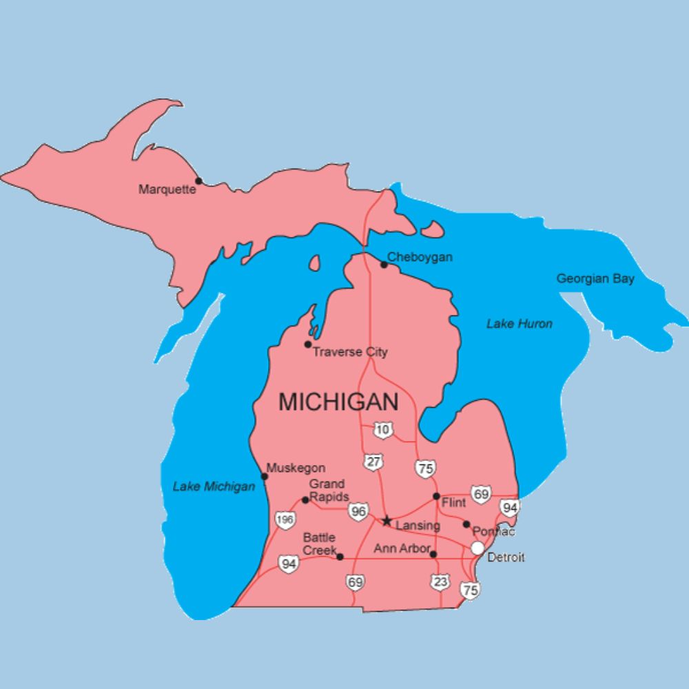
Major cities and populated areas are strategically identified, offering insights into the urban landscape and distribution of communities across the state. The intricate network of rivers and lakes, including the expansive Great Lakes—Superior, Michigan, Huron, and Erie—is intricately illustrated, emphasising the state's rich aquatic topography.
Click here to download a detailed PDF file of the Michigan Map.
Michigan Geographical Area
Michigan, distinguished by its distinctive geography, assumes an unusual shape as it occupies two distinct peninsulas. Spanning an expansive area of 250,485 square kilometres (96,713 square miles), Michigan surpasses the size of the United Kingdom. As the largest among the East North Central states, it is noteworthy that Michigan could be accommodated almost seven times within the expanse of Alaska.
Known as the Wolverine State, Michigan is intricately divided into the Upper and Lower Peninsulas. Historically, these peninsulas were physically isolated until the landmark construction of the Mackinac Bridge in 1957. This engineering marvel facilitated seamless access between the two regions, transcending the geographical divide and uniting the Upper and Lower Peninsulas.
1. Upper Peninsula
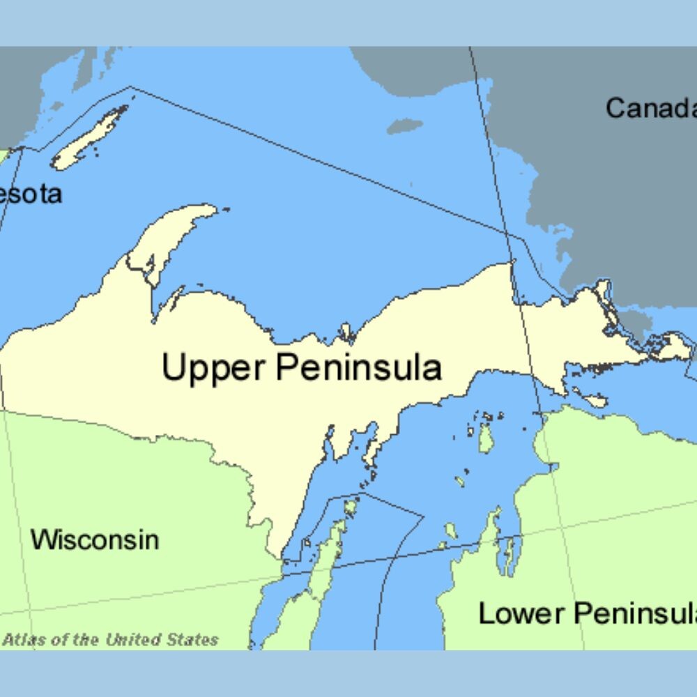
The Upper Peninsula of Michigan boasts a diverse topography, characterised by low-rolling hills and intermittent swamps in the eastern region, and elevated hills exhibiting rugged terrain in the western expanse. The eastern sector aligns with the Great Lakes Plain, contributing to a relatively gentler landscape. In contrast, the western section, extending from Lake Superior into the Porcupine Mountains, is situated within the Superior Upland, showcasing more elevated and rugged geographical features. This unique blend of terrains adds to the distinctive charm and natural diversity of Michigan's Upper Peninsula.
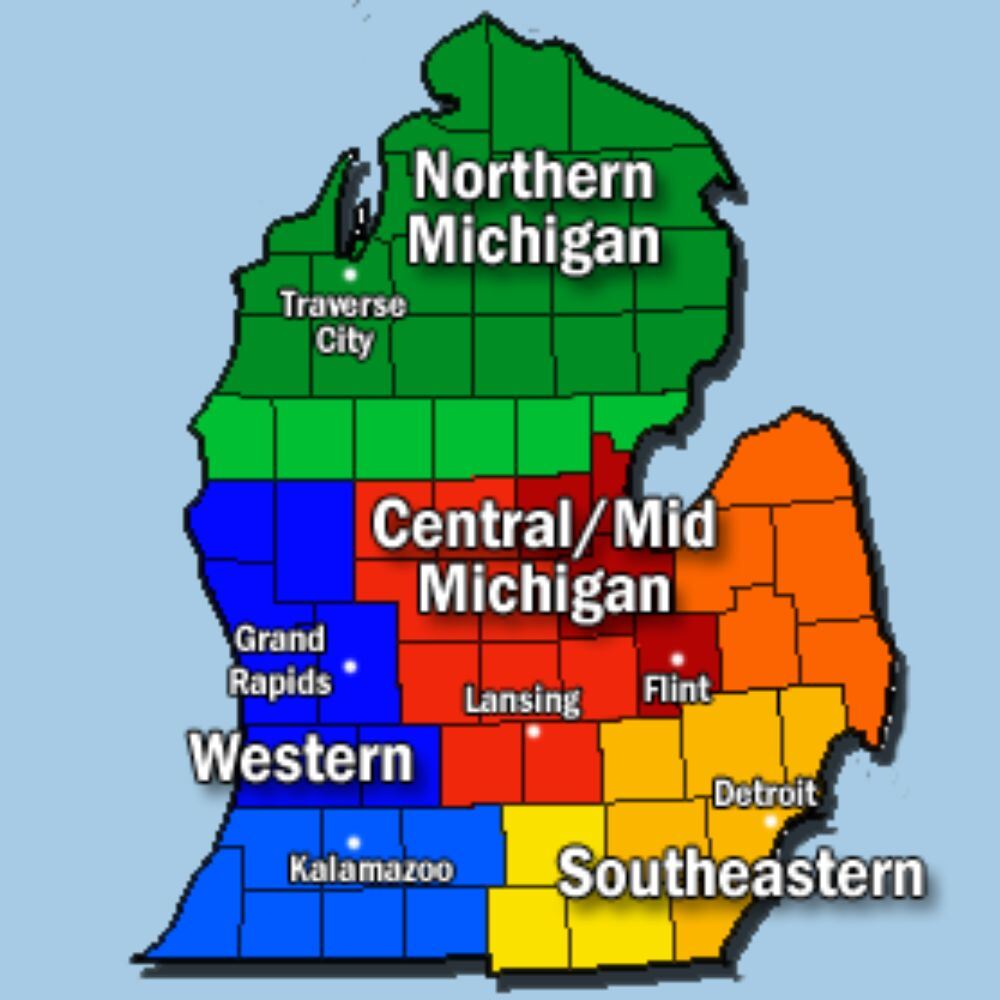
2. Lower Peninsula
SOURCE| Wikipedia
The Lower Peninsula, an integral component of the Great Lakes Plains, is flanked by Lake Michigan to the west, Lake Huron and Lake Erie to the east, and bordered by Indiana and Ohio to the south. Its topography encompasses a spectrum of features, characterised by low-rolling hills in the southernmost region and flatlands interspersed with hills in the northernmost sector. This varied terrain contributes to the geographical richness of Michigan's Lower Peninsula, offering a diverse landscape that ranges from gentle slopes to more undulating expanses.
The Lower Peninsula includes four major landforms.
- The southern portion of the peninsula is enveloped by the hilly moraines region, characterised by the presence of moraines—accumulated rocks and sediment transported and deposited by glaciers, shaping low ridges across the landscape. This distinctive geological formation contributes to the undulating terrain found in the lower half of the peninsula, creating a landscape shaped by the dynamic forces of glaciation and subsequent deposition.
- In the Lower Peninsula, the Beaches and Dunes region showcases a captivating juxtaposition of low forest-covered expenses intermingled with towering bear dunes. This scenic area reflects the harmonious interplay between lush greenery and imposing sand formations.
- Moving north from Muskegon-Saginaw Bay, the High Plains and Moraines section unfolds, characterised by elevated ridges that contribute to a more varied and rugged topography.
- Extending from the Saginaw Bay area to the tip of the Lower Peninsula, the Eastern Lower Plains Lowlands constitute a significant stretch, encompassing the state's most industrialised segment, which includes the vibrant city of Detroit. This region, marked by its economic activity, stands in contrast to the natural landscapes found in other parts of the peninsula, illustrating the diversity that defines Michigan's Lower Peninsula.
ALSO READ| List of States in USA - Check How Many States in USA?
Michigan Cities and Towns
Detroit is considered a major city for its industries and Great Lakes Shipping Centre:
| Cities And Towns | |||||
| Detroit | Grand Rapids | Warren | Sterling Heights | Lansing | Ann Arbor |
| Flint | Dearborn | Livonia | Adrian | Alma | Alpena |
| Battle Creek | Bay City | Benton Harbor | Big Rapids | Burton | Cadillac |
| Cheboygan | Clare | Coldwater | Copper Harbor | Crystal Falls | East Lansing |
| Escanaba | Frankfort | Gaylord | Gladstone | Grand Haven | Grayling |
| Hancock | Harrisville | Holland | Houghton | Iron Mountain | Ironwood |
| Ishpeming | Jackson | Kalamazoo | Kentwood | L'Anse | Ludington |
| Mackinaw City | Manistee | Manistique | Marquette | Menominee | Midland |
| Monroe | Mount Pleasant | Munising | Muskegon | Negaunee | Newberry |
| Niles | Norton Shores | Ontonagon | Owosso | Petoskey | Pontiac |
| Port Austin | Port Huron | Portage | Reed City | Rogers City | Saginaw |
| Sault Ste. Marie | Saint Ignace | Saint Johns | Saint Joseph | Standish | Tawas City |
| Taylor | Three Rivers | Traverse City | Troy | Wyoming | |
Michigan History
During the era spanning 1660 to the termination of French dominion, Michigan constituted an integral component of the Royal Province of New France.
Pioneering the exploration and settlement of the region in the 17th century were French-Canadian fur traders and Jesuit missionaries. In 1691, the French erected Fort St. Joseph, a trading post strategically positioned along the St. Joseph River. Subsequently, in 1701, they inaugurated Fort Pontchartrain du Détroit (Fort Detroit), a bastion that swiftly evolved into a pivotal hub for fur trade and shipping.

The turning point arrived in 1760 when British forces seized French Montreal, marking the culmination of the French and Indian War (1754–1763). Consequently, the territory now known as Michigan seamlessly transitioned into the fold of the British Province of Quebec. The demographic landscape of Michigan Territory, primarily encompassing Detroit and its environs, experienced a gradual expansion until the transformative inauguration of the Erie Canal in 1825. This engineering feat linked the Great Lakes and the Hudson River with New York City and the Atlantic Ocean, triggering an unprecedented surge in population. By the 1830s, Michigan boasted an impressive resident count of 80,000, surpassing the requisite threshold for pursuing statehood. On January 26, 1837, President Andrew Jackson affixed his signature to a legislative bill officially conferring sovereignty upon Michigan. Subsequently, Michigan ascended to statehood as the 26th member of the Union.
ALSO READ| Largest State in the USA by Population
Race and Ethnic groups
| Ethnicity | Percentage |
| White alone | 74.90% |
| African American | 14.10% |
| Hispanic or Latino | 5.20% |
| Asian | 3.40% |
| Native American | 0.70% |
Michigan Population
Ranked as the 10th most populous state in the United States, Michigan boasts a population nearing 10 million as of the estimated count in July 2023. The state's administrative hub is Lansing, while its most populous city is Detroit, home to the largest metropolitan area in Michigan—Metro Detroit, which stands as the second-largest metropolitan area in the entire United States.
In addition to Detroit, Michigan hosts several other major cities, each with a population exceeding 100,000 residents. Among these urban centres are Grand Rapids, Warren, Sterling Heights, Ann Arbor, and Flint, contributing to the diverse and vibrant demographic tapestry of the state.


Comments
All Comments (0)
Join the conversation