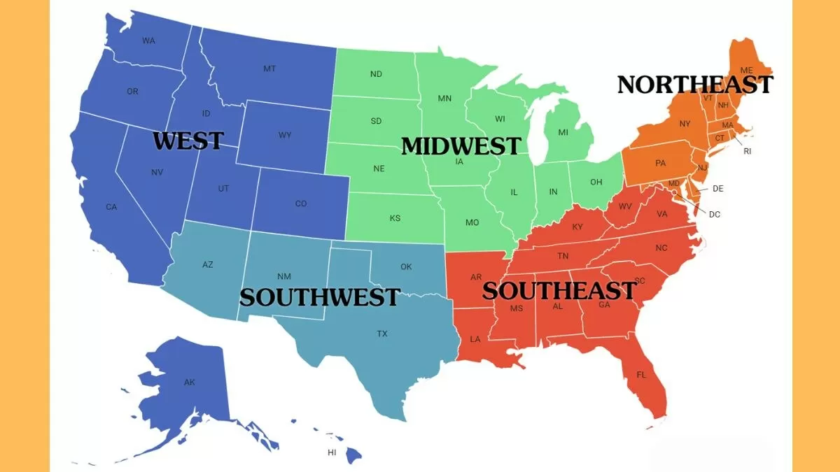
Welcome to the United States of America, a vibrant nation comprising 50 states and a diverse tapestry of geographic, social, and cultural regions! Often called the "land of opportunity," the US is a melting pot of unique areas that shape the country's identity. From the bustling Northeast to the sun-kissed Southeast, the heartland of the Midwest, the desert landscapes of the Southwest, and the rugged beauty of the West, each region brings its own flavor to the American story.
ALSO READ| List of States in USA - Check How Many States in USA?
List of Regions Of United States
Did you know that the United States is divided into regions in different ways? In everyday conversations, we often refer to five regions: Northeast, Southeast, Midwest, Southwest, and West. However, the US Census Bureau uses a slightly different approach, grouping the country into four regions: Northeast, Midwest, South, and West.
Meanwhile, other government agencies like the Bureau of Economic Analysis and the Office of Management and Budget use even more detailed systems, dividing the country into eight or ten regions. It's fascinating to see how different perspectives shape our understanding of the country's geography. Here is the complete list:
U.S. Census Regions and Divisions | ||
| Region | Division | States |
| Northeast | New England | Connecticut, Maine, Massachusetts, New Hampshire, Rhode Island, Vermont |
| Middle Atlantic | New Jersey, New York, Pennsylvania | |
| Midwest | East North Central | Illinois, Indiana, Michigan, Ohio, Wisconsin |
| West North Central | Iowa, Kansas, Minnesota, Missouri, Nebraska, North Dakota, South Dakota | |
| South | South Atlantic | Delaware, Florida, Georgia, Maryland, North Carolina, South Carolina, Virginia, Washington, D.C., West Virginia |
| East South Central | Alabama, Kentucky, Mississippi, Tennessee | |
| West South Central | Arkansas, Louisiana, Oklahoma, Texas | |
| West | Mountain | Arizona, Colorado, Idaho, Montana, Nevada, New Mexico, Utah, Wyoming |
| Pacific | Alaska, California, Hawaii, Oregon, Washington | |
Federal Reserve Banks | ||
| Federal Reserve Bank | Location | |
| Boston | Boston, MA | |
| New York | New York, NY | |
| Philadelphia | Philadelphia, PA | |
| Cleveland | Cleveland, OH | |
| Richmond | Richmond, VA | |
| Atlanta | Atlanta, GA | |
| Chicago | Chicago, IL | |
| St. Louis | St. Louis, MO | |
| Minneapolis | Minneapolis, MN | |
| Kansas City | Kansas City, MO | |
| Dallas | Dallas, TX | |
| San Francisco | San Francisco, CA | |
| U.S. Time Zones | ||
| Time Zone | States/Territories | |
| UTC−12:00 | Baker Island, Howland Island | |
| Samoa Time Zone | American Samoa, Jarvis Island, Kingman Reef, Midway Atoll, Palmyra Atoll | |
| Hawaii–Aleutian Time Zone | Hawaii, Aleutian Islands (Alaska), Johnston Atoll | |
| Alaska Time Zone | Alaska (excluding Aleutian Islands) | |
| Pacific Time Zone | Parts of the Pacific U.S. | |
| Arizona Time Zone | Arizona (excluding the Navajo Nation) | |
| Mountain Time Zone | Parts of the Mountain U.S. (excluding most parts of Arizona) | |
| Central Time Zone | Central U.S. | |
| Eastern Time Zone | Eastern U.S. | |
| Atlantic Time Zone | Puerto Rico, U.S. Virgin Islands | |
| Chamorro Time Zone | Guam, Northern Mariana Islands | |
| Wake Island Time Zone | Wake Island | |
U.S. Courts of Appeals Circuits | ||
| Circuit | Region | |
| First Circuit | Maine, Massachusetts, New Hampshire, Puerto Rico, Rhode Island | |
| Second Circuit | Connecticut, New York, Vermont | |
| Third Circuit | Delaware, New Jersey, Pennsylvania, Virgin Islands | |
| Fourth Circuit | Maryland, North Carolina, South Carolina, Virginia, West Virginia | |
| Fifth Circuit | Louisiana, Mississippi, Texas | |
| Sixth Circuit | Kentucky, Michigan, Ohio, Tennessee | |
| Seventh Circuit | Illinois, Indiana, Wisconsin | |
| Eighth Circuit | Arkansas, Iowa, Minnesota, Missouri, Nebraska, North Dakota, South Dakota | |
| Ninth Circuit | Alaska, Arizona, California, Hawaii, Idaho, Montana, Nevada, Oregon, Washington, Guam, Northern Mariana Islands | |
| Tenth Circuit | Colorado, Kansas, New Mexico, Oklahoma, Utah, Wyoming | |
| Eleventh Circuit | Alabama, Florida, Georgia | |
| D.C. Circuit | District of Columbia | |
Environmental Protection Agency Regions | ||
| Region | Office Location | States |
| I | Boston | Connecticut, Maine, Massachusetts, New Hampshire, Rhode Island, Vermont |
| II | New York City | New York, New Jersey, Puerto Rico, U.S. Virgin Islands |
| III | Philadelphia | Delaware, Maryland, Pennsylvania, Virginia, Washington, D.C., West Virginia |
| IV | Atlanta | Alabama, Florida, Georgia, Kentucky, Mississippi, North Carolina, South Carolina, Tennessee |
| V | Chicago | Illinois, Indiana, Michigan, Minnesota, Ohio, Wisconsin |
| VI | Dallas | Arkansas, Louisiana, New Mexico, Oklahoma, Texas |
| VII | Kansas City | Iowa, Kansas, Missouri, Nebraska |
| VIII | Denver | Colorado, Montana, North Dakota, South Dakota, Utah, Wyoming |
| IX | San Francisco | Arizona, California, Hawaii, Nevada, Guam, Northern Mariana Islands, American Samoa |
| X | Seattle | Alaska, Idaho, Oregon, Washington |
Bureau of Economic Analysis Regions | ||
| Region | States | |
| New England | Connecticut, Maine, Massachusetts, New Hampshire, Rhode Island, Vermont | |
| Mideast | Delaware, Maryland, New Jersey, New York, Pennsylvania, Washington, D.C. | |
| Great Lakes | Illinois, Indiana, Michigan, Ohio, Wisconsin | |
| Plains | Iowa, Kansas, Minnesota, Missouri, Nebraska, North Dakota, South Dakota | |
| Southeast | Alabama, Arkansas, Florida, Georgia, Kentucky, Louisiana, Mississippi, North Carolina, South Carolina, Tennessee, Virginia, West Virginia | |
| Southwest | Arizona, New Mexico, Oklahoma, Texas | |
| Rocky Mountain | Colorado, Idaho, Montana, Utah, Wyoming | |
| Far West | Alaska, California, Hawaii, Nevada, Oregon, Washington | |
ALSO READ| Top 10 Most Liberal Cities in the US (2024)
History of Regions Of the United States
These regions of the US have distinct physical and cultural characteristics that set them apart from one another. For instance, the Northeast is known for its dense forests and bustling cities, while the Southwest is recognised for its arid deserts and rich Native American heritage. Meanwhile, the West Coast is famous for its rugged coastline and tech hubs, the Southeast is celebrated for its warm hospitality and rich music history, and the Midwest is beloved for its rolling plains and hearty agriculture. By recognising these regional differences, geographers can better understand the unique challenges and opportunities that shape our country's diverse landscape.

Tropical Regions Of United as per the 1900 consensus
The geographic regions of the United States were first defined during the colonial period, with New England, the Middle Atlantic, and the South emerging as major sections. These designations evolved, with James D.B. DeBow introducing five regions in 1853. Henry Gannett later proposed a new scheme in 1880, grouping states into Atlantic, Great Valley, and Western divisions. By 1910, nine regional divisions had been established, and they have remained largely unchanged since then. Today, the Census Bureau uses these regions to collect and analyse data, making it easier to compare statistics across time and geographic areas.
ALSO READ| 10 Least Populated States In US 2024
Importance of Regions Of the United States
Regions play a vital role in various aspects of our lives. Firstly, they facilitate the administration of government programs in a vast country like the United States. Government agencies have regional offices that oversee program implementation and address queries specific to each region. Secondly, regions enable the collection and comparison of data over time. Well-defined regions allow researchers to track changes, identify trends, and analyse data on population, demographics, and socioeconomic factors. This information helps allocate resources effectively and address issues like labour surpluses and shortages. Lastly, regional names provide a convenient way to communicate in our daily lives, such as reporting news and sharing information. In essence, regions help us organise, analyse, and communicate more efficiently.


-1766337791473.jpg)
Comments
All Comments (0)
Join the conversation