India- Size and Location Class 9 Notes: CBSE Class 9 Geography revision notes for Chapter 1: India- Size and Location are available here. These notes are entirely according to the latest CBSE syllabus for Class 9 Social Science. Check these chapter notes for a quick revision of the chapter.
CBSE Class 9 Geography Chapter-1 India- Size and Location Notes
India is among the ancient civilizations of the world. In the last five decades, India has achieved multi-faceted socio-economic progress. It has moved forward, displaying remarkable progress in the fields of agriculture, industry, technology, and overall economic development.
| Do you know? |
| The southernmost point of the Indian Union– ‘Indira Point’ got submerged under the sea water in 2004 during the Tsunami. |
India:- Location
- India is located entirely in the Northern Hemisphere; the mainland extends between latitudes 8°4'N and 37°6'N and longitudes 68°7'E and 97°25'E.
- The Tropic of Cancer (23° 30'N) divides the country into almost two equal parts.
- To the southeast and southwest of the mainland lie the Andaman and Nicobar Islands and the Lakshadweep Islands in the Bay of Bengal and Arabian Sea, respectively.
India:- Size
- The land mass of India has an area of 3.28 million square kilometres.
- India’s total area accounts for about 2.4 percent of the total geographical area of the world.
- India is the seventh-largest country in the world.
- India has a land boundary of about 15,200 km, and the total length of the coastline of the mainland, including Andaman, Nicobar, and Lakshadweep, is 7,516.6 km.
- India is bounded by the young fold mountains in the northwest, north, and northeast.
- South of about 22° north latitude, it begins to taper and extends towards the Indian Ocean, dividing it into two seas: the Arabian Sea on the west and the Bay of Bengal on its east.
- Time along the Standard Meridian of India (82°30'E) passing through Mirzapur (in Uttar Pradesh) is taken as the standard time for the whole country. The latitudinal extent influences the duration of day and night as one moves from south to north.
India and the world
- The Indian landmass has a central location between East and West Asia. India is a southward extension of the Asian continent.
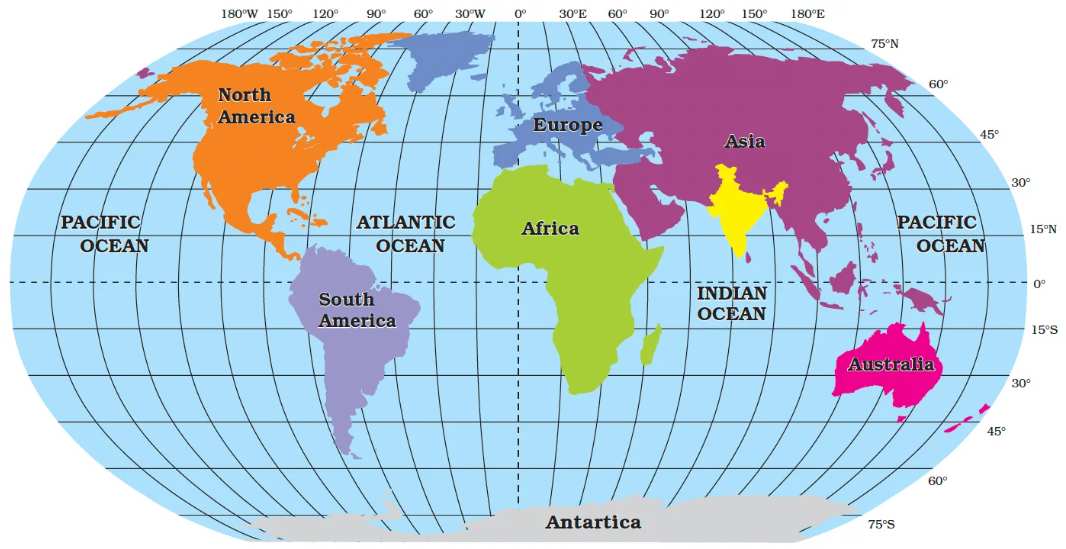
(Source: NCERT)
- The Deccan Peninsula protrudes into the Indian Ocean, thus helping India establish close contact with West Asia, Africa, and Europe from the western coast and with Southeast and East Asia from the eastern coast.
- No other country has a long coastline on the Indian Ocean as India has.
| Do you Know? |
| Since the opening of the Suez Canal in 1869, India’s distance from Europe has been reduced by 7,000 km. |
India and Neighbours
- India occupies an important strategic position in South Asia.
- India has 28 states and eight Union Territories.
.jpg)
- India shares its land boundaries with Pakistan and Afghanistan in the northwest, China (Tibet), Nepal, and Bhutan in the north, and Myanmar and Bangladesh in the east.
- Our southern neighbours across the sea consist of two island countries, namely Sri Lanka and the Maldives.
- Sri Lanka is separated from India by the Palk Strait and the Gulf of Mannar, while the Maldives Islands are situated to the south of the Lakshadweep Islands.
-(1).jpg "CBSE Class 9 Social Science Revision Notes 2024-25, Download Chapter-wise PDF Here")


Comments
All Comments (0)
Join the conversation