List of Districts in Uttarakhand: Uttarakhand is bordered to the northwest by Himachal Pradesh; to the northeast by the Tibet Autonomous Region of China; to the southeast by Nepal, and to the south and southwest by Uttar Pradesh. Its capital is Dehradun. It was formed on 9 November 2000 as the 27th state of India and was carved out of Uttar Pradesh. The new state changed its name to "Uttarakhand" in January 2007.
Uttarakhand: Key Facts
| Area | 53,483 sq.km. |
| Population | 100.86 lakh |
| Capital | Dehradun |
| Districts | 13 |
| Literacy Rate | 78.80% |
| Density | 189 per sq km |
| Latitude | 28°43' N to 31°27' N |
As per the Population Census 2011 published by the Government of India for Uttarakhand state reveal that population of the state has increased by 18.81% in this decade as compared (2001-2011) to the past decade (1991-2001).
Uttarakhand: District Administration
Garhwal Division
Dehradun
Haridwar
Chamoli
Rudraprayag
Tehri Garhwal
Uttarkashi
Pauri Garhwal
Kumaoun Division
Almora
Nainital
Pithoragarh
U S Nagar
Bageshwar
Champawat
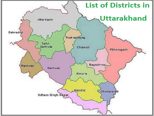
List of Districts in Uttarakhand
| S. No. | District | Area | Population (Census 2011) | Sex Ratio | Literacy | Density |
| 1. | Haridwar | 2360 sq km | 1,890,422 | 880 | 73.43 % | 801 |
| 2. | Dehradun | 3,088 sq km | 1,696,694 | 902 | 84.25 % | 549 |
| 3. | Udham Singh Nagar | 2,908 sq km | 1,648,902 | 920 | 73.10 % | 649 |
| 4. | Nainital | 4,251 sq km | 954,605 | 934 | 83.88 % | 225 |
| 5. | Pauri Garhwal | 5,230 sq km | 687,271 | 1103 | 82.02 % | 129 |
| 6. | Almora | 3,139 sq km | 622,506 | 1139 | 80.47 % | 198 |
| 7. | Tehri Garhwal | 3,642 sq km | 618,931 | 1077 | 76.36 % | 170 |
| 8. | Pithoragarh | 7,090 sq km | 483,439 | 1020 | 82.25 % | 68 |
| 9. | Chamoli | 8,030 sq km | 391,605 | 1019 | 82.65 % | 49 |
| 10. | Uttarkashi | 8,016 sq km | 330,086 | 958 | 75.81 % | 41 |
| 11. | Bageshwar | 2,246 sq km | 259,898 | 1090 | 80.01 % | 116 |
| 12. | Champawat | 1,766 sq km | 259,648 | 980 | 79.83 % | 147 |
| 13. | Rudraprayag | 1,984 sq km | 242,285 | 1114 | 81.30 % | 122 |
Uttarakhand Districts: Facts at a Glance
1. Uttarkashi
Area: 8,016 sq km
Population: 3,30,086
Blocks: 6
Block Names: Bhatwadi, Dunda, Chinyalisaud, Naugaon, Purola, and Mori
Tehsil: 6
Ploce Station: 7
2. Dehradun
Area: 3,088 sq km
Population: 1,696,694
Tehsils: 7
Blocks: 6
Block Names: Raipur, Doiwala, Sahaspur, Vikasnagar, Chakrata, and Kalsi
Villages: 767
3. Rudraprayag
Area: 1,984 sq km
Village: 688
Population: 242,285
Tehsil: 4
Police Station: 5
Blocks: 3
4. Tehri Garhwal
Area: 3642 sq km
Population: 618,931
Villages: 1868
Male: 2,97,986
Female: 3,20,945
Village Panchayat: 1038
Tehsils/SubTehsils: 14
Blocks: 9
Block Names: Fakot(Narendranagar), Chamba, Jaunpur, Thauldhar, Pratapnagar, Jakhanidhar, Hindolakhal, Kirtinagar, and Bhilangna
5. Haridwar
Area: 2360 sq km
Population: 1,890,422
Literacy Rate: 73.43%
Tehsil/Block: 04/06
Tehsil Name: Haridwar, Roorkee, Bhagwanpur, and Laksar
Block Names: Bahadrabad, Bhagwanpur, Roorkee, Narsan, Laksar, and Khanpur
Villages: 643
Municipal Corporation: 2
6. Pauri Garhwal
Area: 5,230 sq km
Population: 687,271
Block: 15
Block Names: Pauri, Kot, Kaljikhal, Khirsu, Pabo, Thalisain, Bironkhal, Nanidanda, Ekeshwar, Pokhra, Rikhnikhal, Jaiharikhal, Dwarikhal,Dugadda, and Yamkeshwar
Villages: 3,484
Municipality: 6
Tehsils: 13
7. Chamoli
Area: 8,030 sq km
Population: 391,605
Literacy Rate: 82.65%
Block: 09
Block Names: Dasholi (Chamoli), Joshimath, Ghat, Pokhari, Karanprayag, Gairsain, Narayanbagar, Thrali, Dewal
Villages: 1244
Police Station: 09
Tehsil: 12
8. Bageshwar
Area: 2246 sq km
Population: 259,898
Literacy Rate: 80.01%
Block: 3
Villages: 947
Municipality: 2
Police Station: 5
Assembly Constituency: 2
9. Pithoragarh
Area: 7090 sq km
Population: 483439
Literacy Rate: 82.25%
Block: 8
Block Names: Bin, Munakot, Didihat, Kanalichina, Dharchula, Munsyari, Gangolihat, and Berinag
Villages: 1657
Municipality: 5
Police Station: 16
Language: 2
10. Almora
Area: 3139 sq km
Forest Area: 1309.40 sq km
Population: 622,506
Literacy Rate: 80.47%
Tehsil: 12
Blocks: 11
Block Names: Bhaisiachana, Bhikiyasain, Chaukhutiya, Dhauladevi, Dwarahat, Hawalbag, Lamgara, Sult, Syalde, Takula, Tarikhet
11. Nanital
Area: 4,251 Sq.Km.
Population: 954,605
Language: Hindi
Male: 4,93,666
Villages: 1141
Female: 4,60,939
Tehsils: 9
Blocks: 8
Block Names: Haldwani, Bhimtal, Ramnagar, Kotabag, Dhari, Betalghat, Ramgarh, and Okhalkanda
Police Station: 15
12. Champawat
Area: 1766 Sq Km
Population: 259,648
Male: 131130
Villages: 705
Female: 128518
Language: Hindi
13. Udham Singh Nagar
Area: 2,908 sq km
Population: 1,648,902
Literacy Rate: 73.10 %
Revenue Villages of Udham Singh Nagar, Tehsils: 656
Urban Local Bodies: 16
Police Station: 17
READ| List of Chief Ministers (CM) of Uttarakhand in chronological order


Comments
All Comments (0)
Join the conversation