CBSE Class 12 Political Science Map Questions: The CBSE Class 12 Political Science Exam 2025 is scheduled for March 22, 2025, and map-based questions are an essential part of the paper. These questions test your understanding of significant political events, international borders, important treaties, and institutions. To help you revise effectively, we have compiled a list of the most important map-based questions that are likely to appear in the exam. Make sure to practise these questions for last minute revision and maximize your score in tomorrow’s exam.
CBSE Class 12 Political Science Map Questions 2025
1. A political outline map of South Asia is given with five countries marked as (A), (B), (C), (D), and (E).Identify them based on the following clues:
i) An important country but not considered a part of South Asia.
ii) A country with a successful democratic system.
iii) A country that has had both civilian and military rulers.
iv) A country that had a constitutional monarchy but is now a democratic country.
v) An island nation that was a Sultanate until 1968.
Answers:
(i) China
(ii) Sri Lanka
(iii) Bangladesh
(iv) Nepal
(v) Maldives
2. A political outline map of the world is given with five countries marked as A, B, C, D, and E.Identify them based on the given clues:
i) The country where the Earth Summit was held in June 1992.
ii) A leading contributor to greenhouse gas emissions.
iii) A country known for its anti-dam and pro-river movements.
iv) A country exempted from the requirements of the Kyoto Protocol.
v) The second-largest producer of crude oil in the world.
Answers:
(A) Brazil
(B) China
(C) India
(D) United States
(E) Saudi Arabia
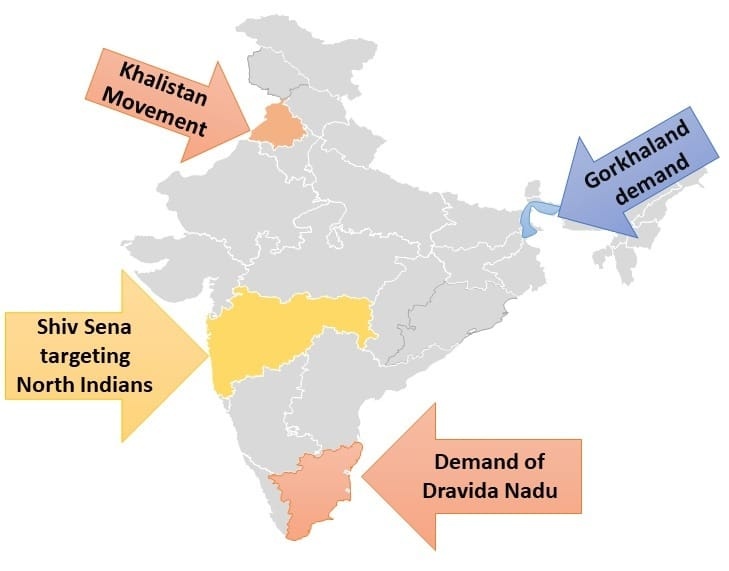
3. Locate places of following movements:
- Gorkhaland demand.
- Demand of Dravida Nadu
- Khalistan Movement.
- Shiv Sena targeting North Indian.
Answers:
4. In the given outline map of India, identify these states based on the given clues:
i) The state where a violent incident took place in 2002 at Godhra.
ii) The state where the Chipko agitation started.
iii) A state that was a princely state before 1947.
iv) The state where the MKSS demanded records for famine relief and labor accounts.
Answers:
(i) Gujarat (Godhra violence, 2002)
(ii) Uttarakhand (Chipko Movement, 1973)
(iii) Hyderabad (Now Telangana) / Rajasthan / J&K (Princely states before 1947)
(iv) Rajasthan (MKSS movement for labor records and RTI)
5. A political outline map of India is given with states marked as A, B, C, and D. Identify them based on the Assembly Election results of 1967:
i) The state where Congress did not get a majority but formed the government with support.
ii) The mountainous state where Congress got a majority.
iii) The southern state where Congress got a majority.
iv) The northeastern state where Congress did not get a majority.
Answers:
(A) West Bengal (Congress lacked majority, formed a coalition)
(B) Himachal Pradesh (Congress got a majority)
(C) Mysore/Karnataka (Congress got a majority)
(D) Assam (Congress did not get a majority)
6. In the given outline political map of the world, four countries have been marked as (A), (B), (C) and (D). Identify these countries on the basis of the information given below and write their correct names in your answer book along with the respective serial numbers of the information used and the concerned alphabets as per the format That follows:
(i) A country that did a nuclear test in the year 1998.
(ii) A communist nation during the Cold War.
(iii)A capitalist country that dropped an atomic bomb on Japan.
(iv) A communist nation initially under Mao Zedong.
Answers:
| Sr. no. of the Information used | Alphabet Concerned | Name of the State |
| (i) | A | India or Pakistan |
| (ii) | B | Soviet Union (USSR) |
| (iii) | C | United States of America (USA) |
| (iv) | D | China |
7. A political outline map of South Asia is given with four countries marked as A, B, C, and D. Identify them based on the following information:
i) An important country but not considered a part of South Asia.
ii) A country with a successful democratic system.
iii) A country that has had both civilian and military rulers.
iv) A country that had a constitutional monarchy.
Answers:
(A) China (Important but not part of South Asia)
(B) India (Successful democracy)
(C) Pakistan (Both civilian and military rulers)
(D) Nepal (Former constitutional monarchy)
8. A world map is given with countries marked as A, B, C, and D. Identify them based on the following clues:
i) The country marked as C. Options: Russia, China, Israel, America.
ii) The country marked as A. Options: Bhutan, Myanmar, Israel, Afghanistan.
iii) The country marked as B. Options: Russia, Japan, Malaysia, China.
iv) The country marked as D. Options: Brazil, Mexico, America, Italy.
Answers:
(A) Myanmar
(B) China
(C) America (USA)
(D) Brazil
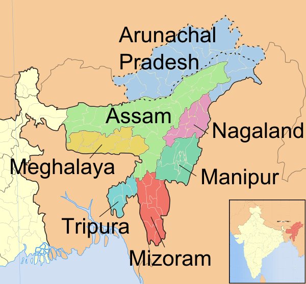
9. Locate 7 sisters on the Map.
Answers: Seven Sisters States:
- Arunachal Pradesh (Borders China, Bhutan, and Myanmar)
- Assam (The gateway to the Northeast, connects all other states)
- Meghalaya (South of Assam, known for Cherrapunji & Shillong)
- Manipur (Borders Myanmar, capital: Imphal)
- Mizoram (Borders Myanmar & Bangladesh)
- Nagaland (Borders Myanmar, capital: Kohima)
- Tripura (Shares a long border with Bangladesh)
Also Check:


Comments
All Comments (0)
Join the conversation