The Indian Meteorological Department (IMD) has issued a warning about weather changes in Mumbai, India due to a cyclonic storm that may develop in the Arabian Sea.
The IMD’s weather update on Monday, outlined that a low-pressure area is likely to develop over the southeast and adjoining east-central Arabian Sea in the next 48 hours.
This low-pressure area has the potential to intensify into a cyclonic storm over the central Arabian Sea around October 21. The IMD has advised fishermen to avoid venturing into the sea along and off the Maharashtra coast and the south Gujarat coast.
Residents along the coast of Maharashtra and south Gujarat are advised to be aware of the latest weather updates and to follow the instructions of local authorities.
If there is any development of a tropical storm then it will be named “Tej” according to the naming process.
A PTI report, according to Mint, mentions: “As of now, the probability of this system intensifying into a cyclonic storm is not very high. The models have yet to confirm it. There is no unanimity in the model forecasts so far. We will have to wait for a few more days for a clear picture to emerge."
A low pressure area has formed over Southeast and adjoining Eastcentral Arabian Sea in the morning of 18th october. To move West-Northwestwards and intensify into a Depression around 21st october. pic.twitter.com/2NEvxANrFo
— India Meteorological Department (@Indiametdept) October 18, 2023
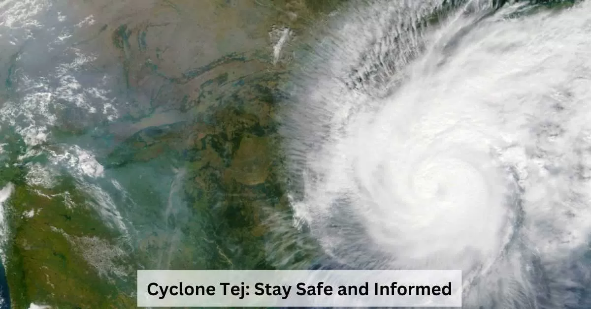
Cyclone Tej Latest Updates
ESCS “Tej” lay centered at 1130 hrs IST of 22 Oct SW Arabian Sea about 130 km east of Socotra (Yemen), 500 km S-SE of Salalah (Oman) and 500 km SE of Al Ghaidah (Yemen). Very likely to move NW and cross Yemen coast close to Al Ghaidah (Yemen) around early hours of 24 Oct as VSCS pic.twitter.com/zPLfBsp7PB
— India Meteorological Department (@Indiametdept) October 22, 2023
Deep Depression over WC BoB moved NW during past 6 hrs and lay centered at 0830 hrs IST of 23 Oct over the same region about 360 km S of Paradip (Odisha), 510 km S-SW of Digha (WB) and 660 km S-SW of Khepupara (Bangladesh). To intensify into Cyclonic Storm during next 6 hrs. pic.twitter.com/hA28ONyUML
— India Meteorological Department (@Indiametdept) October 23, 2023
- The India Meteorological Department (IMD) has issued a new bulletin that states that the deep depression formed over the Bay of Bengal can intensify into a cyclone by Monday evening.
Once it is formed, the cyclonic storm will be named 'Hamoon' by Iran, as per the naming conventions, according to the Mint. - The IMD further informs that the depression over the west-central Bay of Bengal is likely to move towards Bangladesh and adjoining West Bengal coasts over the next three days. It is expected to recurve and move north-northeastwards after moving northwestwards for the next 12 hours. Heavy rainfall is likely over Kerala and Tamil Nadu during the next two days.
- Fishermen are advised not to venture into the Southwest Arabian Sea till 25th October and the Westcentral Arabian Sea till the night of 25th October. Those out at sea are advised to return to the coast.
- In anticipation of heavy rainfall, the Odisha government has asked all district collectors to be prepared for any eventuality and to evacuate people from low-lying areas, if necessary.
Latest Weather Updates:
- A low-pressure area is likely to develop over the southeast and adjoining east-central Arabian Sea over the next 36 hours and intensify into a depression over the central Arabian Sea around October 21.
- A cyclonic circulation is likely to move west-northwestwards and under its influence, a low-pressure area is likely to form over central parts of the Bay of Bengal around October 20.
- October to December is among the favourable periods for the development of cyclones in the Bay of Bengal and the Arabian Sea due to warmer ocean temperatures.
- The IMD predicted moderate rainfall accompanied by thunder and lightning in some parts of Kerala for the next five days due to the cyclonic circulations which it said were expected to gather strength by October 21.
- Tribal areas and high mountain passes in Himachal Pradesh received moderate snowfall during a 24-hour period ending at 3 pm on Tuesday while Narkanda and Kharapatthar in Shimla district witnessed their first snow this month.
- Delhi today recorded a high of 26.2 degrees Celsius, seven notches below normal and the lowest maximum temperature reported in October this year, weather department officials said. Overnight showers in the national capital had led to a dip in the minimum temperature, which settled at 17.2 degrees Celsius, two notches below normal, in the morning.


Comments
All Comments (0)
Join the conversation