-1763016465378.webp)
Maps are undoubtedly one of the most astonishing of humanity’s inventions a reflection of how early people conceived of their surroundings and the world outside. Long before modern maps were made, people in earlier eras chipped, drew, and etched the places around them into stone, bone, and papyrus, recording space, territory, or a spiritual disposition. Maps were much more than navigational aids; they were cultural products, reflections of power and human imagination.
From the engravings made tens of thousands of years ago on mammoth tusks during the Ice Age to mosaic patterns of Byzantine churches, maps open doors into different stories of discoveries and perception. When we look at some of the oldest maps we can find from around the world, we begin to understand human curiosity embrace the power of principle beyond the boundaries of place to engage the inexplicable. Here are the seven oldest maps that are historically significant in cartography.
Check Out: List of Top 10 Oldest Languages in the World (Still Spoken)
Top 7 Oldest Maps in the World
This list has been curated based on the data by Biblical Archaeology Society and presents the name of the map along with the country of its origin and the estimated date and period:
| Rank | Name of Map | Country / Region of Origin | Estimated Date / Period |
| 1 | Mammoth Tusk Map | Czech Republic (Pavlov site) | c. 25,000 BCE |
| 2 | Saint-Bélec Slab | France (Brittany) | c. 1875 BCE |
| 3 | Turin Papyrus Map | Egypt | c. 1150 BCE |
| 4 | Babylonian Map of the World (Imago Mundi) | Iraq (ancient Babylon/Sippar) | c. 700-500 BCE |
| 5 | Madaba Mosaic Map | Jordan | c. 550 CE (6th century CE) |
| 6 | Da Ming Hun Yi Tu (Amalgamated Map of the Great Ming) | China | c. 1389 CE (14th century CE) |
| 7 | Arculf Map of Jerusalem | Jerusalem (recorded in Western Europe) | c. 680 CE |
1. Mammoth Tusk Map (Czech Republic)

Discovered in Pavlov, Czech Republic, the Mammoth Tusk Map has ancient drawings on it believed to be a depiction of rivers, mountains, and settlements. This is widely believed to have been engraved by Ice Age hunter-gatherers, possibly the oldest/current known representation of a real landscape. If utilized in this manner the artifact demonstrates early humans were using spatial symbolism and recognizing their locality 27,000 years ago.
2. Saint-Bélec Slab (France)
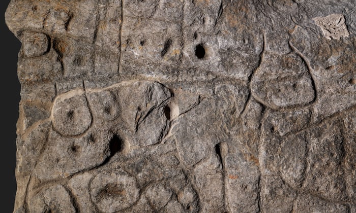
Unearthed in Brittany France, the Saint-Bélec Slab is a Stone Age of the Bronze Age with geometric designs that corresponded to the Odet River Valley. Researchers within a close range at the site believe this stone potentially identified political boundaries or resources. Archaeologists also used 3D analysis to ascertain the local topography with in 80 % accuracy for the area it aligned with, establishing it as Europe's first map of an identifiable locale within at least 4,000 years. An extraordinary achievement for that time in history.
3. Turin Papyrus Map (Egypt)
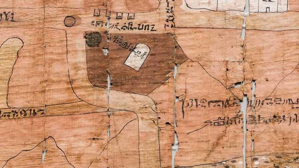
The Turin Papyrus Map is the oldest-known topographical map, produced by the Egyptian scribe Amennakhte during the time of Ramesses IV. It gives a depiction of the Wadi Hammamat area marked with hills, roads, and gold mines. The map was utilized to prepare quarrying missions, suggesting that scientific cartography and the ability to comprehend precise space were starting in ancient Egypt. The map is housed in the Museo Egizio in Turin.
4. Babylonian Map of the World (Iraq)
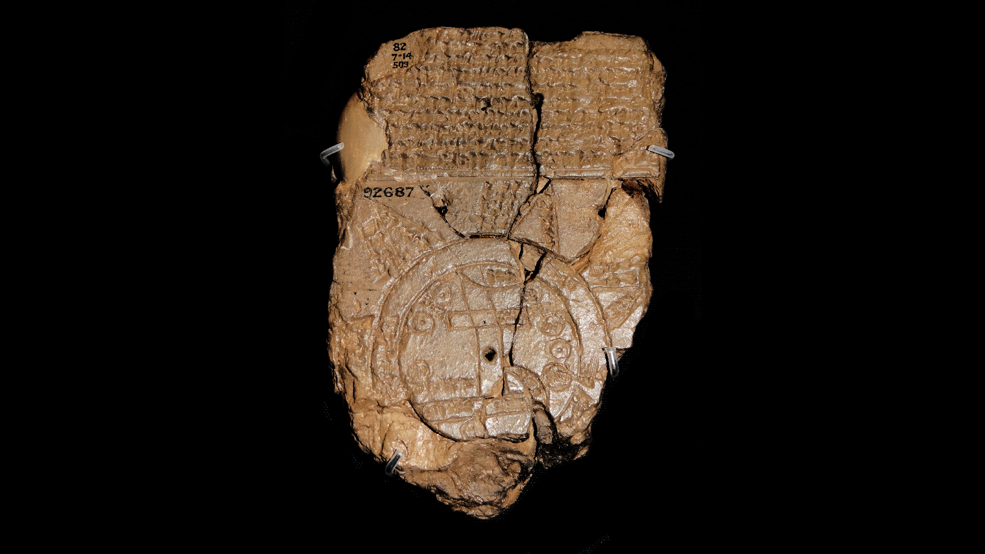
The Babylonian Map of the World, or Imago Mundi, is a clay tablet from the ancient site of Sippar in Iraq. The map depicts Babylon at the center, surrounded by a circular "salt sea." The map combines geography with mythology and is the best representation of the earliest known world map. The Babylonian map represents both physical and spiritual representations of the universe that existed in Mesopotamian civilization. The Babylonian Map of the World is currently located in the British Museum.
5. Madaba Mosaic Map (Jordan)
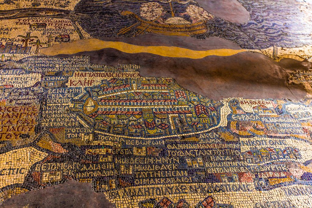
Set in the Byzantine church floor in Madaba, Jordan, the colorful map mosaic describes the Holy Land, and especially the city of Jerusalem, with specific detail of its buildings. It is composed of over two million tiles, and it guided several pilgrims to the cities that were represented in the map during its time. The Madaba Map serves as the earliest surviving cartographic rendering of the Holy Land, bringing together some of geography, faith, and artistic creativity in one of the most sacred parts of Christianity.
Conclusion
These early maps are evidence of humanity's historical attempts to comprehend and visualize the world. These examples, ranging from carved tusks to mosaics, have consequences for geography, culture, and art, and they demonstrate mapping's origins as a practical and culturally meaningful human endeavor.


Comments
All Comments (0)
Join the conversation