Situated in the central expanse of the Pacific Ocean, the Hawaiian archipelago, a group of islands, lies southwest of the continental United States, spanning approximately 4,400 km (2,800 mi) south of Alaska and 4,200 km (2,600 mi) north of Tahiti French Polynesia.
In the early years of the Common Era, around 400 C.E., intrepid Polynesians voyaged from the Marquesas Islands, located 3,550 km (2,200 mi) distant, to establish the first settlements on Hawaii's Big Island, navigating the vast expanse in canoes. The 'discovery' of these islands occurred in 1778 when Captain James Cook, the renowned explorer, set foot, and christened the archipelago as the Sandwich Islands.
ALSO READ| Map of North Carolina (NC): Check Geographical Areas, Population, Cities and Towns
Hawaii State Map
Illustrated in intricate detail, the map below delineates the geographical features of the US state of Hawaii.
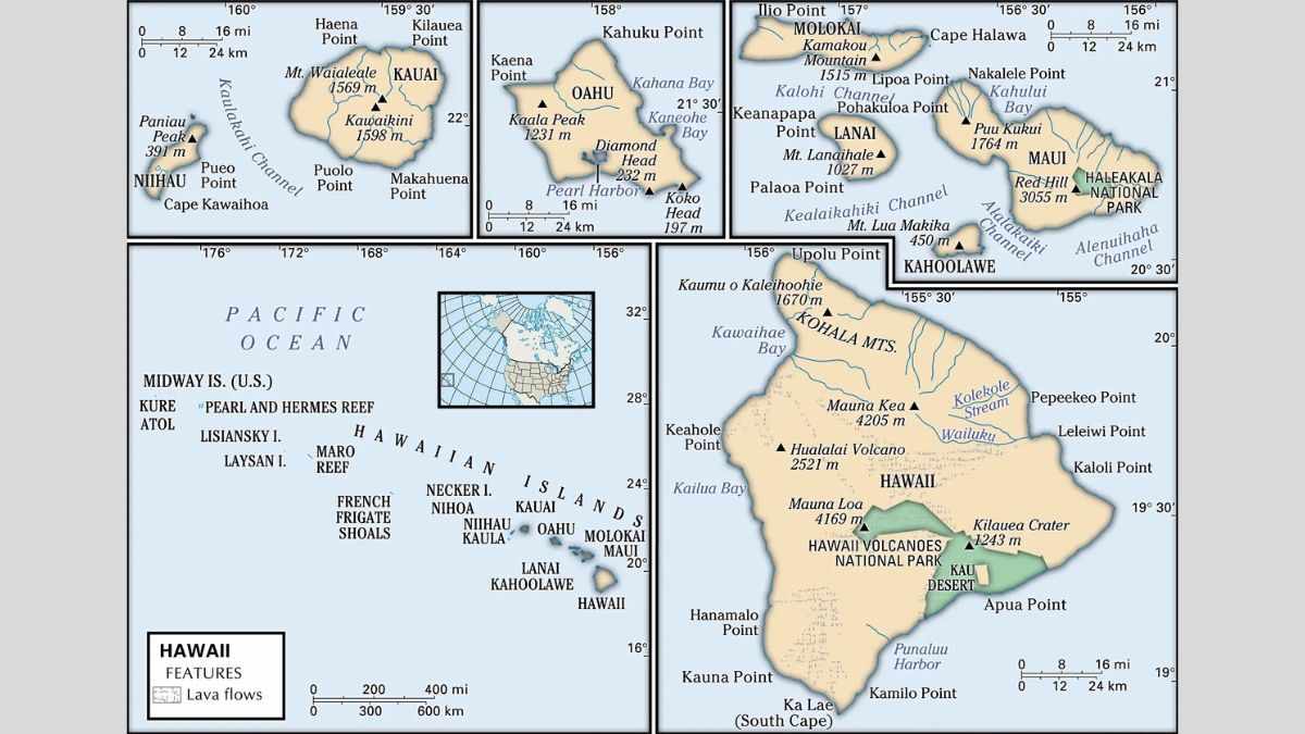
It vividly displays the various islands, the state capital, Honolulu, major cities, populated areas, volcanoes, rivers, and the intricate network of roads crisscrossing the landscape.
Hawaii Geographical Area
The geographical allure of Hawaii is nothing short of awe-inspiring. Emerging from the depths of the abyssal Northeast Pacific Basin, the islands boast an average depth of 5,000 m. Serving as the exposed peaks of the Hawaiian-Emperor seamount chain, this colossal submarine mountain range traces its origins to volcanic activity across various hotspots in the earth's mantle, stretching an impressive 6,200 km (3,900 mi) from the Aleutian Trench in the far northwest Pacific to the island of Hawaii.
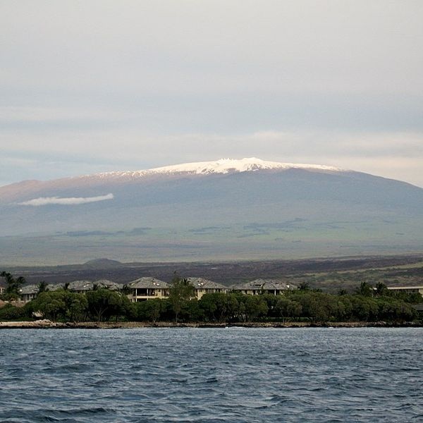
Mauna Kea
Dubbed The Aloha State, Hawaii comprises numerous islands spanning a vast distance exceeding 2,400 km (1,500 mi). Encompassing a total area of 28,313 km² (10,932 sq mi), it is just slightly smaller than Belgium (30,528 km²) and approximately twice the size of the Bahamas. In comparison to other US states, Hawaii surpasses the dimensions of New Jersey but is dwarfed by Texas, which can accommodate the island state 25 times within its expansive borders. Dominating the island's skyline, Mauna Kea stands as Hawaii's loftiest peak, a dormant volcano ascending 4,205 m (13,796 ft) above sea level. Yet, when measured from its base on the ocean floor to its summit, its staggering height reaches 10,203 m (33,476 ft), solidifying its status as the tallest mountain on Earth.
ALSO CHECK| Map Of Texas
Hawaii Cities And Towns
Here is a list of the famous cities and towns of Hawaii:
| Cities And Towns | |||
| Honolulu | East Honolulu | Pearl City | Hilo |
| Captain Cook | Haleiwa | Hana | Hanalei |
| Hawi | Honokaa | Honolulu | Kahului |
| Kailua | Kailua | Kalaupapa | Kaneohe |
| Kapaa | Kaunakakai | Kekaha | Lahaina |
| Laie | Lanai City | Lihue | Maunaloa |
| Mountain View | Pahala | Pahoa | Pearl City |
| Puuwai | Wahiawa | Waialua | Wailuku |
| Waimea | |||
Hawaii World Heritage Sites
Hawaii proudly boasts not one but two distinguished UNESCO World Heritage Sites, each encapsulating the unique essence of the archipelago.
The Hawaiʻi Volcanoes National Park, a designated American National Park, stands as a testament to natural marvels. Encompassing the island of Hawaii, the park showcases two active and remarkable volcanoes – Kīlauea and Mauna Loa. Mauna Loa, recognised as the world's largest shield volcano, shares the stage with Kīlauea, one of the planet's most dynamically active volcanoes. This site serves as an exemplary illustration of island-building through volcanic processes, where the ever-shifting landscape, shaped by volcanic eruptions, reveals extraordinary geological formations. Amidst this dramatic backdrop, the park harbours rare bird species, endemic flora, and vast forests of towering giant ferns.
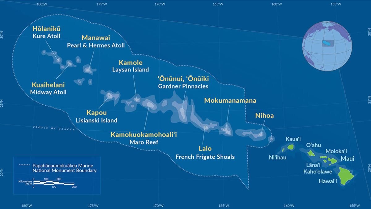
Papahānaumokuākea| Boundary And Location
The second UNESCO World Heritage Site, the Papahānaumokuākea, unfolds as a vast and secluded cluster of diminutive, low-lying islands and atolls, embraced by their surrounding ocean. Commencing approximately 250 km to the northwest of the primary Hawaiian Archipelago, this Marine National Monument stands as one of the world's largest protected areas, spanning over 1930 km. Beyond its sheer geographical expanse, the archipelago holds profound cosmological and traditional significance in the living Native Hawaiian culture. Revered as an embodiment of the Hawaiian concept of kinship between humanity and nature, it stands as a symbol of deep cultural connection.
ALSO CHECK| Map Of Michigan
Hawaii Race and Ethnic Groups
Hawaii's demographic composition reflects a rich tapestry of diversity. Asian individuals contribute 37.6%, and Caucasians make up 21.8%. Here is the complete breakdown:
| Ethnicity | Percentage |
| Asian | 37.60% |
| Caucasian | 21.80% |
| Hispanic or Latino | 10.70% |
| Native Hawaiian | 10.20% |
| African American | 2.20% |
| Native American | 0.40% |
Hawaii Population
As of July 2023, Hawaii sustains a population of 1,435,138 individuals. The preeminent hub of the state, serving as the capital, principal port, and largest city, is Honolulu. The Island of Oahu, the largest urban expanse in Hawaii, encompasses approximately two-thirds of the entire state population. Recognised as the third largest among the Hawaiian Islands, Oahu stands as a focal point of habitation.
The official languages of Hawaii are English and Hawaiian, reflecting the cultural and linguistic diversity that contributes to the unique character of the state.
ALSO READ|


-1766043524791.jpg)
Comments
All Comments (0)
Join the conversation