India inaugurated the Darchula-Lipulekh pass link road on 8 May, 2020 cutting across the disputed Kalapani area which is used by the Indian pilgrims to Kailash Mansarovar.
The Kalapani dispute between Nepal and India was aroused when India publishes a revised political map in November 2019 that shows the newly created Union Territories of Jammu & Kashmir and Ladakh. Both the countries laid claim to Kalapani. The map showed Kalapani as part of Pithoragarh. As a result, Nepal protested immediately and drew attention to the issue.
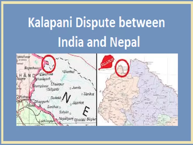
Location of Kalapani or where is it located?
Kalapani is located in the easternmost corner of Uttarakhand's Pithoragarh district. It shared a border on the north with the Tibet Autonomous Region of China and Nepal in the east and south. The region is placed in between Limpiyadhura, Lipulekh, and Kalapani trijunction between Nepal-India and China (Tibet). At an altitude of 3600m, it is located on the banks of the river Kali. The territories of Kalapani lies at the eastern border of Uttarakhand in India and Nepal’s Sudurpashchim Pradesh in the West.
The area is under whose control?
It is under the control of India but Nepal claims the region due to historical and cartographic reasons.
Which States of India share boundaries with Nepal?
What is the reason behind the dispute?
Kalapani region derives its name from the Kali river. Nepal claims the region as the river became the marker of the boundary of the kingdom Nepal following the Treaty of Sugauli. The treaty of Sugauli was signed between the Gurkha rulers of Kathmandu and the East India Company after the Gurkha War/Anglo-Nepal War during 1814-16. In 1816, the treaty was ratified.
- As per the treaty, the regions of Kumaon-Garhwal in the west and Sikkim in the east were lost by Nepal.
- As per Article 5, the King of Nepal gave up his claims over the region west of the river Kali which originated in the High Himalayas and flows into the great plains of the Indian subcontinent.
- Also according to the treaty, the rulers of the British recognised the right of Nepal's to the region that fell to the east of the Kali river.
History of the origin of the dispute
- As per the experts of Nepal, the east of the Kali river should begin at the source of the river. And the source according to them is the mountains near Limpiyadhura. It is higher in altitude than the rest of the river's flow.
- And Nepal claims that the landmass that is in the high mountains falls to the east of the entire stretch starting from Limpiyadhura downwards in theirs.
- According to India, the border starts at Kalapani and India says that is where the river begins. As per the Indian government, the ridgeline located towards the east of Kalapani territory is a part of the Indian Union. The Sugauli treaty mentions nothing about this ridgeline.
- The main reason behind the dispute is the varying interpretation of the origin of the river and its different tributaries that slice via mountains.
- Nepal claims the territory east of the Kali that is based on the Limpiyadhura origin and India says that the river actually takes the name Kali near Kalapani.
The Kalapani area is controlled by the Indo-Tibetan Police and nearby areas since the Indo-China war of 1962.
Claims of Nepal for Lipulekh pass
In the 1952 war, the importance of Himalayan passes with the Tibetan plateau was highlighted. During the war, the forces of the Chinese used the pass Se La in Twang and reached the plains of the Brahmaputra in the east. The military defeat in the east said that weakly guarded passes were a major vulnerability of Indian military preparedness against China. Lipulekh was vulnerable in comparison to Se La that was somewhat fortified. Further, according to the Nepali analysts, the King of Nepal Mahendra signed an agreement with Delhi and handed the region for security purposes to India. Under bilateral negotiations in 1969, all the posts were removed barring Kalapani.
According to the former Indian Ambassador to Nepal Jayant Prasad, "the region was always a part of India and India's claims to the areas based on British Indian maps dating back to the 19th century." He further told that when the pilgrimage to Kailash Mansarovar paused with the takeover of Tibet by Chinese forces within the mid-1950s, India deployed troops at the Lipulekh pass in 1959, who was a part of the Eminent Persons Group established in February 2016 to make sure frank conversation between India and Nepal on controversial issues.
Importance of Lipulekh pass
The region is in the Himalayas and is connected to the other side of the mountain range via Lipulek Pass which has been used for centuries by Hindu and Buddhist pilgrims and tourists to Kailash Mansarovar. By various mountain communities, the region of the market has been used. As we know that the Himalayas have various passes that connect the Gangetic region with the Tibetan plateau but the Lipulekh pass is strategically located as it is the nearest to the heart of the Indian state or National Capital Region.
India and China Lipulekh agreement of 2015 renewed India's Mansarovar pilgrimage connection. Further, India and China were in clear violation of the Nepalese concerns during the 2015 agreement. Also, neither of the countries consulted Nepal or took its opinion before that agreement that enhances the pilgrimage and trade to Tibet.
The current position: A revised official map is published by Nepal incorporating the territory from the Limpiyadhura source of the Kali to Kalapani and Lipulekh pass in the northeast of the triangular region as its territory. The Cabinet led by Prime Minister K.P. Sharma Oli on 22 May registered a constitution amendment motion to grant constitutional status to the map. As per India, this move will not make any solution for the future on the Kalapni issue and is nearly impossible as a constitutional guarantee will make Kathmandu's position inflexible.


Comments
All Comments (0)
Join the conversation