In a major step toward road safety, Noida has become among the first cities in India to roll out real-time speed limit displays on Google Maps. This tech-driven initiative puts both the current speed and the prescribed speed limit for each major road of Noida right inside the navigation interface of the motorist. The move is expected to check overspeeding, reduce accidents, and encourage responsible driving habits.
What is the Real-Time Speed Limit Feature in Google Maps?
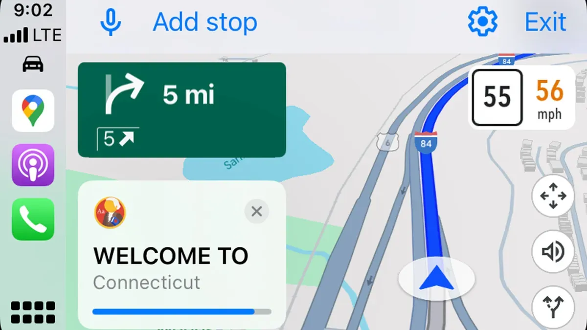
Google Maps now includes the official speed limit on each mapped road segment. They appear right next to your speedometer in the app.The integration is based on real-time, authoritative data provided by the Noida Traffic Police and updated dynamically by Google in partnership with Lepton Software.
The feature is functional on 248 major roads across Noida and Greater Noida, with variable limits for different categories of vehicles: cars, bikes, and heavy vehicles.
How Does the Feature Work?
While driving, drivers are able to view their current speed alongside the legally stated limit for that route.If they go over the speed limit, there are visual prompts in the app that tell them to slow down. That creates self-discipline and compliance in real time.
This information is regularly synched and updated to ensure accuracy, factoring in recent regulation changes, including ongoing roadwork.
Why was this feature launched in Noida?
According to city data, 53% of the road accidents in Noida are related to overspeeding.
-
The new feature, by giving instant feedback about speed compliance, is supposed to halve accidents and fatalities due to speeding.
-
It also enhances "citizen policing," or a sense of self-regulation, rather than relying on enforcement and fines.
How to Use the Speed Limit Feature on Google Maps
-
Make sure your app is updated on iOS or Android.
-
Start driving in Noida; the speed limit displays will appear alongside your speedometer.Some of the routes will trigger accident-prone zone alerts, further enhancing safety.
Check out: List Of Countries With The Most Time Zone
Benefits and Impact on Commuters
-
Empowers daily commuters and delivery drivers to follow traffic rules without guessing.
-
It minimizes the risk of traffic fines and legal complications.Improves safety among passengers by ensuring steady driving in a regulated manner, even on long journeys or rush hour.
-
Provides immediate awareness of speed limits even if roadside signage is unclear or missing.
How Accurate is the Speed Limit Data?
Google Maps derives this speed limit information from databases of traffic police, GPS, AI-driven image recognition of road signs and traffic patterns, and periodic manual updates. This keeps information up to date, even when routes or regulations change.
Will the feature expand to other cities?
After their pilots ran successfully in cities such as Gurugram, Faridabad, Kolkata, Mumbai, and more recently Noida, Google in India is gradually rolling out real-time speed limits and accident zone alerts to other major urban centers of the country, thanks to ongoing partnerships with civic authorities.
What Is the Result of Speed Limit Violation?
If you exceed the speed limit, Google Maps flashes visual reminders to slow down. However, enforcement remains a matter of local authorities, and violations may be subject to fines or penalties under city traffic laws.
A Safer, Smarter Commute for Noida With real-time speed limits on Google Maps, Noida is attempting to introduce a technology-powered approach toward road safety.This move mixes convenience with compliance in order for drivers to make more informed decisions, minimizing the chances of accidents and setting up a yardstick for smart traffic management which other Indian cities will likely emulate.


Comments
All Comments (0)
Join the conversation