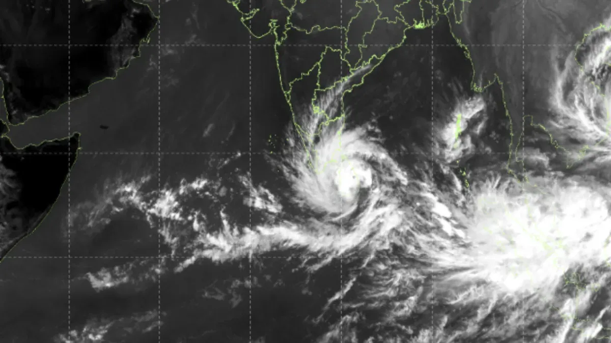
Cyclone Ditwah (variously reported as Ditwa/Ditwah) is an active tropical cyclonic storm that formed over the southwest Bay of Bengal close to the Sri Lankan coast in late November 2025. It is the fourth cyclonic storm of the 2025 North Indian Ocean cyclone season and has already brought severe weather to Sri Lanka, besides triggering a cyclone alert for parts of South India.
Formation and Meteorological Background
-
The origin of Cyclone Ditwah was from a low‑pressure area over the southwest Bay of Bengal and the adjoining Sri Lanka coast, which rapidly intensified into a deep depression and further intensified into a cyclonic storm by November 27, 2025.
-
According to IMD, the system lay over coastal Sri Lanka and the adjoining southwest Bay of Bengal, moving north-northwestwards at a speed of about 13-17 km/h. The maximum sustained surface winds were about 65-70 km/h and higher gusts, with 4-5-m-high waves.
Track, Landfall and Areas at Risk
IMD and regional centres indicate that Cyclone Ditwah is likely to:
-
Move nearly north‑northwestwards across the southwest Bay of Bengal and along/near the Sri Lankan coast.
-
Approach and hit north Tamil Nadu, Puducherry and the adjacent south Andhra Pradesh coast around November 30, and the landfall is likely between Puducherry and the south Andhra coast.
Sri Lanka has already faced:
-
Extremely heavy rainfall (200+ mm in some districts), flooding, and landslides, especially along eastern and central regions.
-
Dozens of fatalities and missing persons, several thousand displaced to temporary shelters, with major rivers in spate and homes and infrastructure damaged on a large scale.
For India, the IMD bulletins and media reports highlight:
-
Heavy to very heavy rainfall over coastal and interior Tamil Nadu, Puducherry, and parts of south coastal Andhra Pradesh, with isolated extremely heavy falls on November 29–30.
-
Winds possibly reaching 70–90 km/h during closest approach/landfall, rough to very rough seas, and risk of storm surge, localised flooding, uprooted trees and disruption to road, rail and air traffic.
ALSO READ: SIR Electoral Roll Bihar: Excluded from the List? Here’s How You Can File an Objection
Meaning and Naming of “Ditwah”
"Ditwah" is a name contributed by Yemen in the rotating list of cyclone names used for the North Indian Ocean basin. The name refers to Ditwah Lagoon, an attractive natural feature in Yemen's Socotra region. In naming tropical cyclones, countries generally choose a culturally or geographically significant name.
Official Warnings and Preparedness Measures
IMD has issued:
-
Yellow and orange alerts for parts of Tamil Nadu and Andhra coasts for heavy rain, strong winds and rough sea conditions.
-
Advisories to fishermen to completely avoid venturing into southwest and west‑central Bay of Bengal and along Tamil Nadu, Puducherry–Andhra coasts until the system weakens.
-
State governments and disaster agencies have:
-
Placed coastal districts of Tamil Nadu, Puducherry, and south Andhra on high alert, with schools likely to be shut in vulnerable areas and relief centres being readied.
-
The deployed NDRF/SDRF teams launched evacuations in low-lying and landslide-prone areas in Sri Lanka as well as in some Indian coastal belts.
Environmental and Seasonal Context
-
Cyclone Ditwah is part of the post‑monsoon North Indian Ocean cyclone season, which occurs from October to December, wherein warm Bay of Bengal waters and favourable wind patterns often create powerful storms impacting Sri Lanka and peninsular India.
-
Experts note that Ditwah intensified quickly from deep depression to cyclone because of high sea‑surface temperatures and conducive atmospheric conditions-a pattern that is increasingly discussed in the context of climate variability.
1. How is Cyclone Ditwah different from Cyclone Senyar?
While Cyclone Senyar that formed earlier over the Strait of Malacca mainly affected Indonesia and seas adjacent to it, largely sparing the Indian mainland, Ditwah is tracking towards north Tamil Nadu–Puducherry–south Andhra Pradesh with higher direct impact potential on the Indian coast.
2. Which Indian states are under greatest risk?
The highest risk zones are:
-
Coastal and adjoining interior districts of Tamil Nadu (especially north and Delta districts)
-
Puducherry
-
South coastal Andhra Pradesh
These regions can expect heavy rain, strong winds, local flooding, and possible storm surges around November 29–30.
3. What precautions should coastal residents take?
-
Authorities and IMD advisories recommend: Avoid sea travel and fishing until official clearance. Avoid beaches and low-lying coastal stretches during peak impact.
-
Secure loose objects, prepare emergency kits, keep power banks and essential medicines ready.
-
Follow evacuation orders right away and get updates only from official weather bulletins.
4. Why are Sri Lanka and Tamil Nadu so frequently hit by Bay of Bengal cyclones?
Their location along the southwest and west‑central Bay of Bengal places them directly in the typical track of many post‑monsoon cyclones that form near the equatorial Indian Ocean and curve northwestwards toward the subcontinent
ALSO READ: What is ASD List? How to Check Your Name if Deleted from Draft Electoral Rolls (Direct Link)


-1764324098961.jpg)
Comments
All Comments (0)
Join the conversation