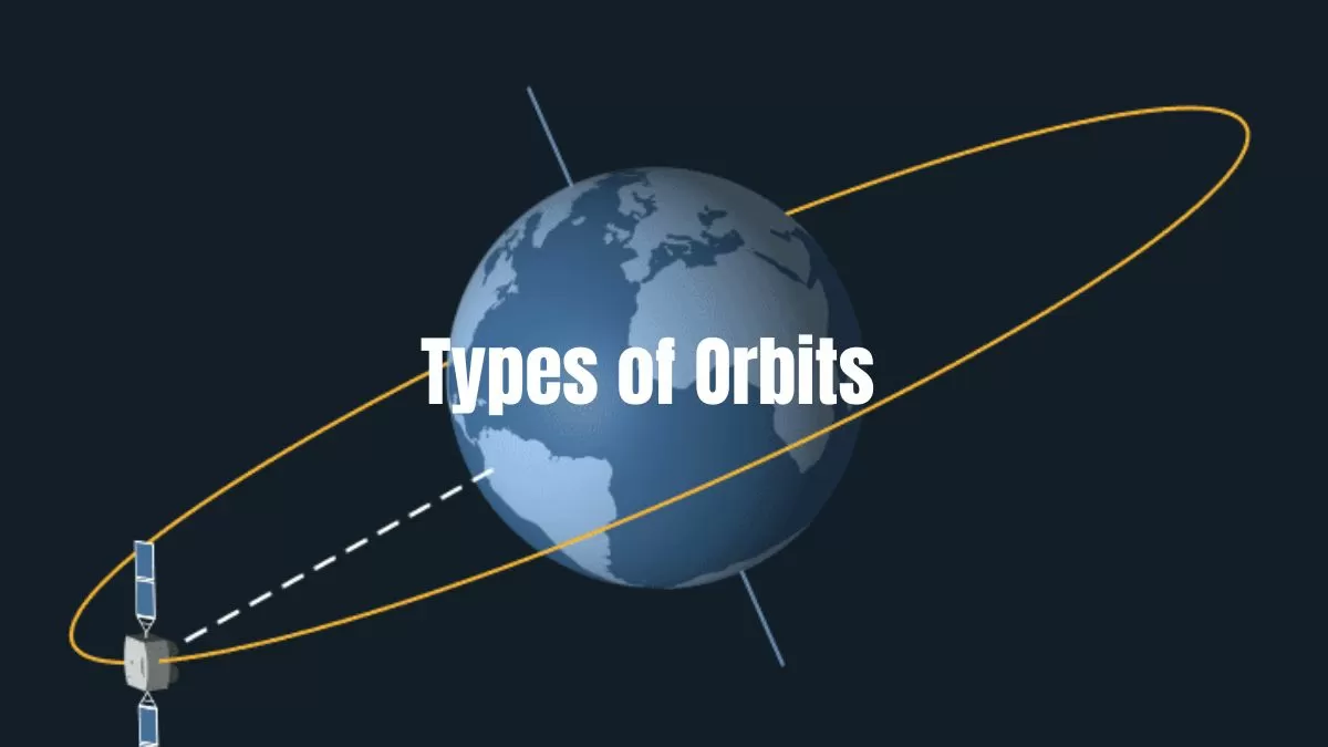
Understanding the various types of orbits is essential for grasping how satellites and spacecraft manoeuvre around Earth and other celestial bodies. Each orbit type serves a specific purpose based on its altitude and trajectory, impacting everything from communications to Earth observation.
This article explores the key types of orbits: Geostationary Orbit (GEO), Low Earth Orbit (LEO), Medium Earth Orbit (MEO), Polar Orbit, Sun-Synchronous Orbit (SSO), Transfer Orbit, and Geostationary Transfer Orbit (GTO).
But, first, let us understand the science behind how objects remain in orbit.
How Do Objects Stay in Orbit?
According to Newton's first law of motion, an object in motion will remain in motion unless acted upon by an external force. Without gravity, a satellite orbiting Earth would continue moving straight into space. However, gravity pulls it back toward Earth, creating a continuous tug-of-war between the satellite’s forward momentum and the gravitational pull.
For an object to remain in orbit, its momentum and the gravitational force must be perfectly balanced. If the object's forward momentum is too high, it will escape Earth’s gravitational pull and drift into space. Conversely, if the momentum is too low, gravity will pull it down, causing it to fall. When these forces are balanced, the object constantly falls towards Earth, but its high sideways speed ensures it never actually hits the surface.
Let us now dive into different types of orbits in space.
Types of Orbits and their applications
Geostationary Orbit (GEO)
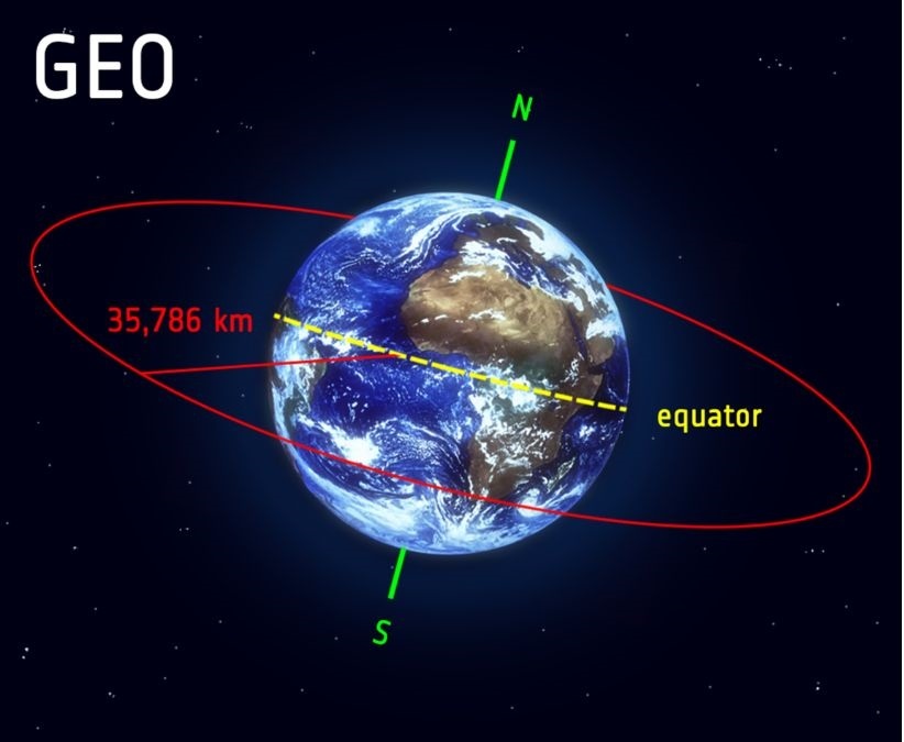
Image: ESA
Geostationary Orbit (GEO) is a unique and highly significant orbit where a satellite appears to remain stationary relative to a point on Earth's surface. Positioned approximately 35,786 kilometres (22,236 miles) above the Equator, satellites in GEO orbit the Earth from west to east, matching the Earth's rotational speed. This means they complete an orbit in exactly 23 hours, 56 minutes, and 4 seconds—the same time it takes Earth to make a full rotation on its axis.
To achieve this synchronization, satellites in GEO must travel at a velocity of about 3 kilometres per second. This precise speed ensures that the satellite maintains a fixed position relative to the Earth's surface, effectively hovering over the same spot. This characteristic is particularly advantageous for communication satellites, weather monitoring systems, and broadcasting services.
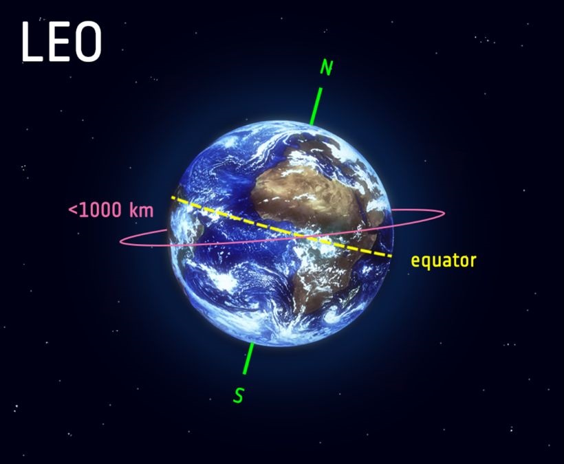
Image: ESA
As its name implies, Low Earth Orbit (LEO) is an orbit situated relatively close to Earth's surface. Typically, LEO is defined as an orbit with an altitude ranging from 160 kilometres (100 miles) to less than 1,000 kilometres (620 miles) above Earth. To put this into perspective, commercial airplanes generally fly at altitudes no greater than approximately 14 kilometres (8.7 miles), making even the lowest LEO significantly higher—over ten times greater—than typical aircraft altitudes.
Unlike satellites in Geostationary Orbit (GEO), which must orbit along the Earth's equator, LEO satellites have the flexibility to follow various orbital paths, as their orbital plane can be tilted. This flexibility is one reason why LEO is a popular choice for many satellite missions.
The proximity of LEO to Earth offers several advantages. It is the preferred orbit for high-resolution imaging satellites because the shorter distance to the surface allows for clearer and more detailed photographs. Additionally, the International Space Station (ISS) operates in LEO, as the shorter distance simplifies travel to and from space, allowing astronauts to make the journey more efficiently. Satellites in LEO travel at speeds around 7.8 kilometres per second, which means they complete an orbit around Earth approximately every 90 minutes. As a result, the ISS orbits Earth about 16 times a day.
However, the rapid movement of LEO satellites across the sky poses challenges for communication tasks. Their swift passage requires ground stations to constantly track them, which can be cumbersome. To address this, communications satellites in LEO often work as part of large constellations. These constellations, consisting of multiple satellites, create a network that ensures continuous coverage by working together. By deploying several satellites in coordinated orbits, these constellations form a "net" around Earth, providing extensive and consistent coverage.
Medium Earth Orbit (MEO)
Medium Earth Orbit (MEO) occupies the space between LEO and GEO, generally ranging from 2,000 kilometres (1,240 miles) to about 35,786 kilometres (22,236 miles) above Earth. Satellites in MEO orbits typically complete an orbit around Earth in several hours, travelling at speeds between 3 to 4 kilometres per second.
MEO is notably used for navigation satellites, such as those in the Global Positioning System (GPS). These satellites provide coverage over larger areas than LEO satellites and offer continuous, accurate location data essential for global navigation and positioning. Unlike GEO satellites, which remain fixed over a specific region, MEO satellites can cover different parts of the Earth, making them crucial for comprehensive navigation systems.
Science Quiz On Space Debris With Answers
Polar Orbit and Sun-Synchronous Orbit (SSO)
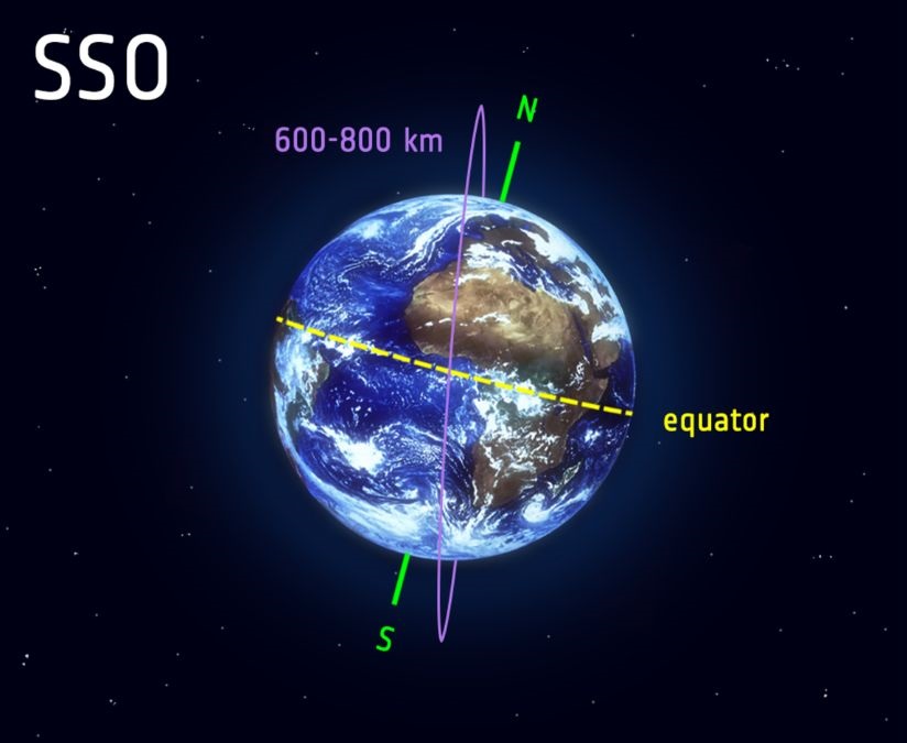
Image: ESA
Satellites in polar orbits travel across Earth's surface from north to south, passing over the poles. These orbits are categorized as low Earth orbits, typically ranging from 200 to 1,000 kilometres (124 to 620 miles) above Earth. While satellites in polar orbits do not need to pass directly over the North and South Poles, deviations of up to 20 to 30 degrees are still considered polar orbits.
A specialized variant of the polar orbit is the Sun-Synchronous Orbit (SSO). Satellites in SSO are unique in that they maintain a fixed position relative to the Sun. This synchronization ensures that the satellite consistently observes the same point on Earth at the same local solar time. For instance, a satellite in SSO might pass over Paris at noon each day.
This consistent timing is crucial for various applications. It allows scientists and analysts to take a series of images of the same location under similar lighting conditions, which is essential for monitoring changes over time. For example, tracking weather patterns, observing natural disasters like forest fires or floods, and studying long-term environmental issues such as deforestation and rising sea levels all benefit from this consistent observation.
Often, satellites in SSO are positioned to constantly observe dawn or dusk. By orbiting in such a way, they avoid being shadowed by the Earth, ensuring continuous data collection. Typically, satellites in SSO operate at altitudes between 600 and 800 kilometres (373 to 497 miles) and travel at speeds around 7.5 kilometres per second at the higher end of this range.
Transfer Orbits and Geostationary Transfer Orbit (GTO)
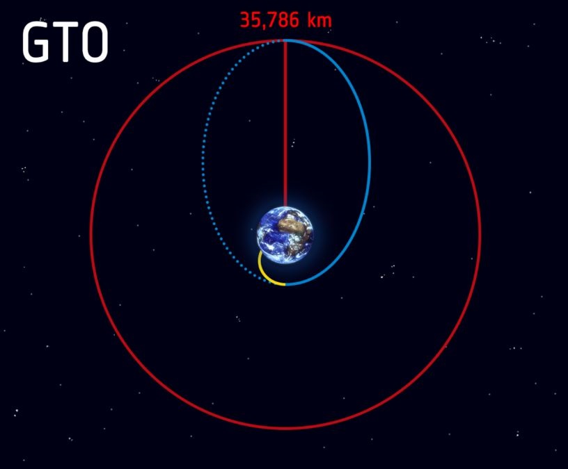
Image: ESA
Transfer orbits are used to transition satellites from one orbit to another, facilitating their deployment into designated operational orbits. One common type of transfer orbit is the Geostationary Transfer Orbit (GTO), which is employed to move satellites from Low Earth Orbit (LEO) to Geostationary Orbit (GEO).
After launch, a rocket follows a trajectory, depicted by the yellow line in the diagram, to reach space. Once it reaches the intended position, the rocket releases the satellite, which then follows an elliptical path, represented by the blue line. This elliptical orbit takes the satellite further from Earth. In this orbit, the farthest point from Earth is known as the apogee, while the closest point is the perigee.
When the satellite reaches the apogee at the GEO altitude of 35,786 kilometres, it activates its engines to shift into a circular GEO orbit, illustrated by the red line in the diagram. Thus, the GTO is characterized by the blue trajectory that connects the yellow orbit with the red GEO orbit.
Conclusion
The different types of orbits—GEO, LEO, MEO, Polar, SSO, Transfer Orbits, and GTO—play critical roles in space missions and satellite operations. By understanding these orbits, we gain insight into how satellites provide communication, navigation, and Earth observation services. Each orbit offers distinct advantages based on altitude, trajectory, and purpose, highlighting the intricate planning required for successful space missions. Whether for scientific exploration, practical applications, or academic study, mastering these orbital concepts is essential for anyone interested in space and satellite technology.


Comments
All Comments (0)
Join the conversation